Bukovniško jezero - Bukovniško jezero (path around the lake)
Starting point: Bukovniško jezero (187 m)
| Latitude/Longitude: | 46,66901°N 16,33932°E |
| |
Route name: path around the lake
Walking time: 30 min
Difficulty: easy marked way
Elevation gain: 2 m
Elevation difference along the route: 30 m
Map: Pomurje 1:40.000
Recommended equipment (summer):
Recommended equipment (winter):
Views: 797
 | 1 person like this post |
Access to starting point:
Leave the Pomurje motorway at the Gančani exit, then follow the signs to Renkovci and further to Dobrovnik. When we reach the main road Murska Sobota - Lendava in Dobrovnik, we continue right, a little further we go left towards Bukovniško jezero. A short drive follows and we arrive at the arranged parking lot in front of Bukovniško jezero.
The parking lot is paid.
Route description:
From the parking lot we continue along the path that runs parallel to the road and quickly brings us to a marked junction where the path to Strehovske gorice and the path to sv. Vid branches off to the left.
We continue straight and shortly afterwards emerge from the forest, from where we climb the embankment of Bukovniško jezero via stairs.
Upon reaching the embankment we go left and arrive at the love bridge with a view of Bukovniško jezero. After the bridge a short ascent via stairs follows, then the path splits.
The marked path continues slightly left towards sv. Vid and further to Bogojini, we continue right and proceed along the path running by the lake. Further on we walk along a gravel road leading along the western shore of the lake. Upon arriving at the northwestern part of the lake we go right from the junction, and when we reach a wider gravel road a little further we go right again. We continue along the path that runs somewhat right of the road and temporarily follows the route of the former forest railway. The path, along which we notice some information boards, later brings us to Ribiška koča, behind which the path turns left and semicircularly bypasses a smaller bay. On the other side of the bay we reach the embankment, in the middle of which we go left downhill and return to the starting point along the access path to the lake.

Photos:
 1
1 2
2 3
3 4
4 5
5 6
6 7
7 8
8 9
9 10
10 11
11 12
12 13
13 14
14 15
15 16
16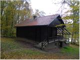 17
17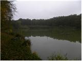 18
18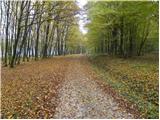 19
19 20
20 21
21 22
22 23
23 24
24 25
25 26
26 27
27 28
28 29
29 30
30 31
31
Discussion about the trip Bukovniško jezero - Bukovniško jezero (path around the lake)
To post a comment you must log in:
If you do not yet have a username, you must first
register.