Čepinci (pokopališče Čepinci) - Gorički breg
Starting point: Čepinci (pokopališče Čepinci) (318 m)
| Latitude/Longitude: | 46,85703°N 16,21855°E |
| |
Walking time: 45 min
Difficulty: easy unmarked way
Elevation gain: 44 m
Elevation difference along the route: 75 m
Map: Pomurje 1:40.000
Recommended equipment (summer):
Recommended equipment (winter):
Views: 301
 | 1 person like this post |
Access to starting point:
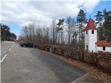
From the road Murska Sobota - Hodoš, in the settlement Šalovci in front of a gas station Ina, we turn left in the direction of Čepinci and Markovci. Further, we drive through Markovci to Čepinci, from where we follow the signs for Hungary. When we get to the parking lot at the smaller cemetery, by which there is a larger chapel, we park.
Route description:
From the parking lot, we continue the ascent on the asphalt road which quickly ascends to a panoramic ridge, and then the path leads us past individual houses. There follow a few shorter ascents and descents, and a little before the border crossing, we go left towards the Border museum (Graničarski muzej).
Behind the museum building, where there are some information boards and memorials, we continue past a few more houses, and then the asphalt ends and the path leads us along the state border between Slovenia and Hungary, where we notice some marks of the hiking trail Po dolaj pa bregaj. The mentioned path soon turns right on the Hungarian side, and we continue on a macadam road which leads us past the cross with Jesus and Mary. A little further from the cross, before the road starts descending towards the next houses, we go slightly left on a cart track which we follow to the nearby water tank. At the water tank, the cart track ends, and through a strip of forest on a footpath we get to the transmitters on Gorički breg.
Description and pictures refer to the condition in March and April 2021.

Photos:
 1
1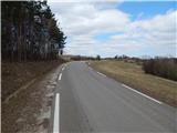 2
2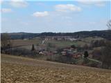 3
3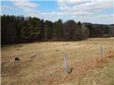 4
4 5
5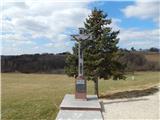 6
6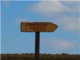 7
7 8
8 9
9 10
10 11
11 12
12 13
13 14
14 15
15 16
16 17
17 18
18 19
19 20
20 21
21 22
22 23
23 24
24
Discussion about the trip Čepinci (pokopališče Čepinci) - Gorički breg
To post a comment you must log in:
If you do not yet have a username, you must first
register.