Cerovec pod Bočem - Boč (via Balunjača)
Starting point: Cerovec pod Bočem (275 m)
| Latitude/Longitude: | 46,24798°N 15,64607°E |
| |
Route name: via Balunjača
Walking time: 3 h 30 min
Difficulty: partly demanding marked way
Elevation gain: 703 m
Elevation difference along the route: 865 m
Map:
Recommended equipment (summer): helmet
Recommended equipment (winter): helmet, ice axe, crampons
Views: 735
 | 1 person like this post |
Access to starting point:
a) From the Ljubljana - Maribor motorway take the Dravlje exit, then follow the signs for Šentjur and further to Rogaška Slatina. When approaching Rogaška Slatina do not drive towards the settlement, but continue in the direction of Rogatec. A little further we arrive at the settlement Cerovec pod Bočem, where we park behind the intersection where the road to Sv. Florijan branches off to the left.
b) From the Maribor - Ljubljana motorway take the Slovenska Bistrica south exit, then follow the signs for Rogaška Slatina. When approaching Rogaška Slatina do not drive towards the settlement, but continue in the direction of Rogatec. A little further we arrive at the settlement Cerovec pod Bočem, where we park behind the intersection where the road to Sv. Florijan branches off to the left.
Route description:
From the parking lot carefully cross the main road at the pedestrian crossing, then head to the road towards Sv. Florijan, soon noticing red mountain direction signs for Grilova kapela and Boč along the path. Initially we walk on the sidewalk, after a few minutes the path turns east and forks a little further on. Before the chapel continue on the left road, where the markers continue. We continue between some houses of the settlement Cerovec pod Bočem, following the markers, higher up the asphalt path takes us into the gorge of Tržiški potok. For some time we continue along the mentioned gorge, then the road turns sharply left and gradually moves away from the stream.
A bit higher the signs for Grilova kapela and Boč direct us left onto a side road (straight to ranč Stojnšek), along which we continue ascending.
Higher we go left again, then past Grilov vodnjak we emerge from the forest, where on the left, at the edge of the forest we notice Grilova kapela.
Here we go right in the direction of Boč and Ložno and return to the forest. We then ascend the slopes of Grilov vrh (612 m), higher up reaching a larger clearing on the northern side of the mentioned peak.
Here a view opens from the southern part of the clearing reaching all the way to the Kamnik-Savinja Alps, we go right, where we bypass an older wooden hut on the right side. Only a short ascent on the cart track follows and we reach a forest road, where the marked path forks.
Continue straight towards Boč (right Rudijev dom and Ložno), where we steeply ascend the marked path. The path ahead first leads through a belt of bushes, from where some views open, then the path enters the forest through which it still ascends quite steeply. Higher up the path and the slope flatten, we follow the marked path to the marked junction, from which we continue straight to the nearby road (right Donačka gora).
When we reach the road go left, left also at the nearby intersection (right Makole). A short descent on the gravel road follows, when we leave the forest past a shrine we arrive at an intersection, from which we go straight (left the road leads down to the valley towards Rogaška Slatina) and bypass the Gavez farmstead on the left side, on the right the nearby Rogaška Slatina hunting lodge.
Behind the lodge we descend to another road and follow it to the right. When the road starts ascending a marked path branches off to the right leading towards Formila and Makole, we continue on the asphalt road which starts ascending. After a short ascent the road forks, we continue on the slightly left road which starts descending (slightly right road leads to a private house). A descent on the gravel road follows, which a bit lower brings us to an intersection, where we go right downhill towards Boč. We also continue descending, at the next intersection where we join the path from Makole we go left. Just a little further we go right. From the last intersection we walk on the road only briefly, then go left onto the marked path, which ascends on a cart track to the place where there once stood a forestry hut, now a new hut is being built (status May 2022).
Here we step onto the road again, which we follow to the left (across the road an unmarked path to Boč leads, or we can join the road leading towards Boč). We continue walking on the road which crosses the slopes of Boč to the left, we first ascend gently on it, later descending slightly.
Some 10 steps before reaching the asphalt road a shady path to Boč branches off to the right, we continue to the road, where we continue right. When the road turns left, continue slightly right and continue on the worse road going into the forest, at the junction go right in the direction of the path via Balunjača and in the direction of the climbing path to Boč (left downhill Dom na Boču - 2 minutes).
The path ahead leads on a gentle road that ascends transversely to the left and crosses the power line route. When we reach the south-western ridge of Boč the Detičkova pot from Zgornja Poljčane joins from the left, we continue on the road to its end at the turning area.
Continue left on the rutted, reinforced and partially fenced path, which soon brings us to a junction, where we leave the usual easy path to Boč. Head left in the direction of the climbing path and the path via Balunjača. A short, fairly flat transverse ascent to the left to the cliffs follows, where the first protections appear. The path is not particularly demanding, but especially in spring and after rain it is exposed to falling rocks.
At the beginning of the secured section a very demanding secured path to Boč branches off to the right, we continue straight in the direction of the path via Balunjača. A transverse ascent on the steep slope follows, where special caution is needed especially when wet. After the next secured section we arrive at the Balunjača cave, just a few dozen steps further there is another cave. The steepness of the slope above the caves eases a bit, the path turns right and ascends transversely above the steep part. When the terrain flattens, the climbing path joins from the right.
Continue slightly left and at the red mountain signs join the usual path. Continue following the markers to the fenced military area, which we bypass on the right side. We walk briefly without major elevation changes, then ascend again and quickly reach the summit of Boč with the lookout tower. In good weather it is worth climbing it, as a wonderful view opens in all directions.
Starting point - Grilova kapela 0:45, Grilova kapela - Boč 2:45.

Photos:
 1
1 2
2 3
3 4
4 5
5 6
6 7
7 8
8 9
9 10
10 11
11 12
12 13
13 14
14 15
15 16
16 17
17 18
18 19
19 20
20 21
21 22
22 23
23 24
24 25
25 26
26 27
27 28
28 29
29 30
30 31
31 32
32 33
33 34
34 35
35 36
36 37
37 38
38 39
39 40
40 41
41 42
42 43
43 44
44 45
45 46
46 47
47 48
48 49
49 50
50 51
51 52
52 53
53 54
54 55
55 56
56 57
57 58
58 59
59 60
60 61
61 62
62 63
63 64
64 65
65 66
66 67
67 68
68 69
69 70
70 71
71 72
72 73
73 74
74 75
75 76
76 77
77 78
78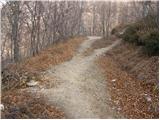 79
79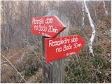 80
80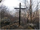 81
81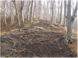 82
82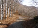 83
83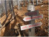 84
84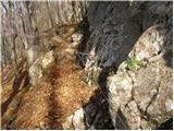 85
85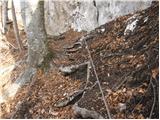 86
86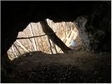 87
87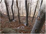 88
88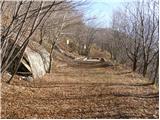 89
89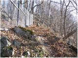 90
90 91
91 92
92 93
93 94
94 95
95 96
96 97
97
Discussion about the trip Cerovec pod Bočem - Boč (via Balunjača)
To post a comment you must log in:
If you do not yet have a username, you must first
register.