Čezsoča - Dolina Škratov (valley of Dwarfs)
Starting point: Čezsoča (350 m)
| Latitude/Longitude: | 46,32090°N 13,56190°E |
| |
Walking time: 1 h 20 min
Difficulty: easy marked way
Elevation gain: 350 m
Elevation difference along the route: 400 m
Map: Julijske Alpe - zahodni del 1:50.000
Recommended equipment (summer):
Recommended equipment (winter): ice axe, crampons
Views: 22.286
 | 3 people like this post |
Access to starting point:
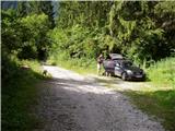
We drive to Bovec and then descend to the village Čezsoča, where in the center of the village we turn left in the direction of Jablance. We then follow a narrow asphalt road to the spot where a macadam road in the direction of the Škratov Valley branches off to the right upward. We follow this road for about 100 m to the parking lot by the road.
Route description:
From the parking lot by the road, we continue on a macadam road which gets worse and gradually changes into a cart track. Along the path, which mostly runs through the forest, a view rarely opens up on the nearby Kanin massif and the Bovško Basin. After a good hour of ascent on the path, along which we notice some decaying shacks, we leave the cart track because the signs for the Škratov Valley direct us right downwards. This is followed by a 10-minute descent on a pleasant forest path surrounded by numerous garden gnomes ("škrati"), which ends at the logbook box on an old wooden cottage.
Photos:
 1
1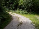 2
2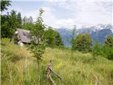 3
3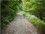 4
4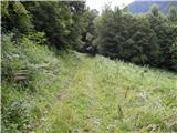 5
5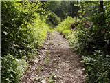 6
6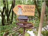 7
7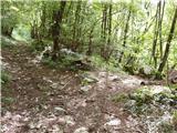 8
8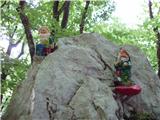 9
9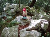 10
10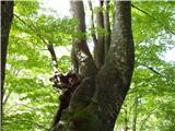 11
11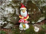 12
12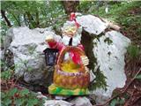 13
13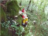 14
14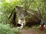 15
15
Discussion about the trip Čezsoča - Dolina Škratov (valley of Dwarfs)
|
| ROBERT23. 08. 2006 |
It's a real rarity to find a whole goblin.... nice walk
|
|
|
|
| ljubica23. 08. 2006 |
What kind of goblins are those? Garden gnomes? LpLj
|
|
|
|
| Gost23. 08. 2006 |
yes, some kind of garden gnomes but they are all crumbled. lp RO
|
|
|
|
| Gost2. 03. 2007 |
actually quite a boring walk, without any nice views. Regards Mike
|
|
|
|
| Gost28. 04. 2007 |
I heard that the dwarves are being ruined by Soča Front enthusiasts. Apparently, just a few meters from the path, one can stumble upon bones and other Isonzo Front remains. This is where the front line ran. They want quiet rummaging for relics, not Disneyland.
|
|
|
|
| Gost18. 02. 2008 |
I counted a total of 22 Škrati (garden gnomes), most of the broken ones have already been replaced with new ones.
I also left them some biscuits, don't touch them, because they are meant for them! 
|
|
|
|
| petruša25. 08. 2009 |
A short time ago we were in Dolina Škratov, very interesting especially for children, at the end you can also visit Slap Slatenik, which is also very beautiful. The easiest way to the waterfall is up the stream bed, because through the forest it's very strenuous.
|
|
|
|
| Maja Tome28. 09. 2009 |
We visited Dolina Škratov on Sunday 27.09.2009, very nice walk, one hour of pleasant uphill walking. Then descent into Dolina Škratov, which is very fairy-tale like, but it's a shame about the broken Škratke. It's quite hard to reach Slatenik waterfall. Shame there's no circular path made to get to the main road.
|
|
|
|
| mizuno12. 08. 2010 |
the most interesting to me was the whistling dwarf.
the summit logbook should be replaced because it's FULL!!!
|
|
|
|
| Bizy12. 08. 2010 |
Excellent really. What sense or point do these dwarfs have, from the pictures it seems pretty childish to me all together.
Is it just a fairy tale? 
|
|
|
|
| turbo13. 08. 2010 |
Every dwarf has his own story 
I'm more interested where Snow White is 
|
|
|
|
| Gorazd G13. 08. 2010 |
Since the dwarves in Dolina Škratov have too much work entertaining children, she went to the mountains to find her prince.
|
|
|
|
| Bizy13. 08. 2010 |
And if she finds her prince, will she get rid of the spiders or not? If not, they'll tell their stories endlessly. 
|
|
|
|
| Škratulja28. 04. 2011 |
Hm,... this is the Valley of Goblins, I recommend to the organizer to place real GOBLINS along the path, not gnomes (there's a difference, because gnomes live in gardens, goblins in forests). Or they could just change the sign to Valley of Gnomes, right?
It's really a pity that someone made an effort and that this Someone really knows nothing about these beings, and thus things can lose their charm. Too bad that things are done only "halfway" and not even maintained. I would gladly respond to the invitation and suggest something.
Lots of inspiration for the future, I wish you
|
|
|
|
| IgorZlodej28. 04. 2011 |
For advice, contact the Vančar inn in Čezsoča.
|
|
|
|
| keti128. 08. 2017 |
Last week we went with the family to Dolina Škratov. The ascent along the cart track is mostly in the shade and quite pleasant, unfortunately more than half of the gnomes are still (or again) broken. Only about five were intact. The kids were quite disappointed about this. Sad that someone is so bothered by them that they destroy them. Even if all were intact, crowds certainly wouldn't flock there.
Otherwise, the descent to the cool Slatenik was a pleasant refreshment.
|
|
|
To post a comment you must log in:
If you do not yet have a username, you must first
register.