Starting point: Ciampac (2142 m)
| Latitude/Longitude: | 46,45750°N 11,78810°E |
| |
Walking time: 1 h 40 min
Difficulty: easy marked way
Elevation gain: 288 m
Elevation difference along the route: 375 m
Map: Tabacco 06, 1:25.000
Recommended equipment (summer):
Recommended equipment (winter): ice axe, crampons
Views: 3.180
 | 1 person like this post |
Access to starting point:
A) From Kranjska Gora over Korensko Sedlo to Austria, where at the first larger intersection we continue left towards Podklošter / Arnoldstein and Trbiž / Tarvisio. At the end of the settlement Podklošter signs for Šmohor / Hermagor direct us right onto a regional road, along which past the mentioned settlement we drive to the end of the Gail Valley, or more precisely to the settlement Kötschach-Mauthen, where we turn right towards the settlement Oberdrauburg. The route ahead leads us over the Alpine pass Gailbergsattel (982 m), after which we descend into the mentioned settlement. After crossing the bridge over the river Drau, we continue left towards the settlement Lienz. In the main roundabout in Lienz we continue "left" in the direction of the settlement Sillian and Italy. Further, we cross the border between Austria and Italy, and we follow the main road to the settlement Dobbiaco / Toblach, where we turn left towards Cortina d'Ampezzo. When we arrive in Cortina d'Ampezzo, we follow the signs for the Alpine pass Passo Falzarego. On the pass Falzarego (2105 m) there is an intersection, where we continue straight downhill in the direction of Marmolada and pass Passo Fedaia. In the next intersections we follow the road in the direction of Marmolada and the mentioned pass. After the pass Fedaia (2057 m), which is located by the artificial lake Lagho di Fedaia, the road starts descending again, and we follow it to the beginning of the settlement Alba, where on the left side we will notice the Ciampac cable car. We park on a large parking lot by the lower station of the mentioned cable car. Then we buy a ticket and ride to the upper station of the Ciampac cable car. From Kranjska Gora to the starting point is approximately 280 km.
B) From Kranjska Gora over the border crossing Rateče to Trbiž / Tarvisio and further on the highway towards Udine. We leave the highway at Tolmezzo, from where we continue driving towards the settlement Ampezzo and further towards the Alpine pass Passo della Mauria (1298 m). The road then starts descending and brings us into the Cadore valley, where we continue right towards the settlement Auronzo di Cadore. In the next intersections we follow the signs for Cortina d'Ampezzo. When we arrive in Cortina d'Ampezzo, we follow the signs for the Alpine pass Passo Falzarego. On the pass Falzarego (2105 m) there is an intersection, where we continue straight downhill in the direction of Marmolada and pass Passo Fedaia. In the next intersections we follow the road in the direction of Marmolada and the mentioned pass. After the pass Fedaia (2057 m), which is located by the artificial lake Lagho di Fedaia, the road starts descending again, and we follow it to the beginning of the settlement Alba, where on the left side we will notice the Ciampac cable car. We park on a large parking lot by the lower station of the mentioned cable car. Then we buy a ticket and ride to the upper station of the Ciampac cable car. From Kranjska Gora to the starting point is approximately 270 km.
C) From Nova Gorica we drive into Italy and further on the highway to Portogruaro, where at the highway junction we turn in the direction of Belluno. We follow the highway to the exit for Belluno, and after the settlement Belluno we follow the road in the direction of the settlement Agordo and then Marmolada and the Alpine pass Passo Fedaia. After the pass Fedaia (2057 m), which is located by the artificial lake Lagho di Fedaia, the road starts descending, and we follow it to the beginning of the settlement Alba, where on the left side we will notice the Ciampac cable car. We park on a large parking lot by the lower station of the mentioned cable car. Then we buy a ticket and ride to the upper station of the Ciampac cable car. From the border with Slovenia to the starting point is approximately 245 km.
Route description:
From the upper station of the cable car on Ciampac we continue on a gravel road, which already after a few meters splits into two parts. We continue straight and after a few minutes of gentle ascent with views on the surrounding peaks we arrive at the hut Rifugio Tobia del Giagher.
From the hut we continue on a well-beaten path, on which through a meadow we quickly walk to the nearby gravel road, to which we only approach very closely. We continue the ascent on the mountain path, which ascends parallel to the mentioned road.
Higher, we join the previously mentioned road, which in the meantime has changed into a steep and rocky cart track. On the cart track, or transport-rescue road, we ascend to the saddle Brunec, where there is a marked junction.
From the saddle we continue in the direction of Buffaure (path no. 613) and begin to descend diagonally across the grassy slopes of the peak Brunec. After a few minutes of traversing with views on the surrounding peaks, we arrive at a smaller saddle between the peaks Brunec and Sass de Porcel.
We continue on a marked and well-beaten path, which on the right side bypasses the less visited Sass de Porcel, then the path brings us to a ridge, which is slightly exposed in some places, but the path is mostly wide enough that it does not cause problems in dry conditions. The increasingly panoramic path ascends somewhat more steeply toward the summit, and with nice views on the surrounding peaks we quickly reach the quite visited summit.

Photos:
 1
1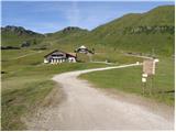 2
2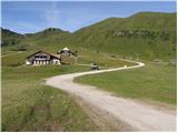 3
3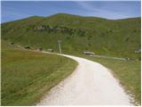 4
4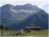 5
5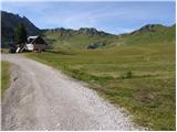 6
6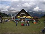 7
7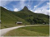 8
8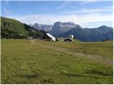 9
9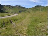 10
10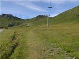 11
11 12
12 13
13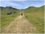 14
14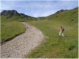 15
15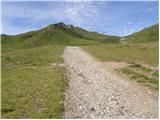 16
16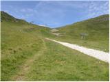 17
17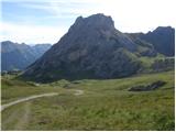 18
18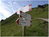 19
19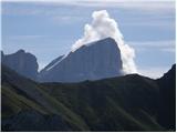 20
20 21
21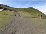 22
22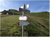 23
23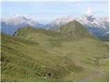 24
24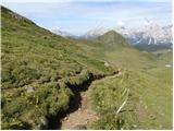 25
25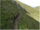 26
26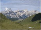 27
27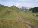 28
28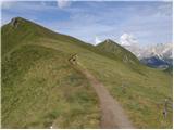 29
29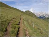 30
30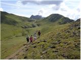 31
31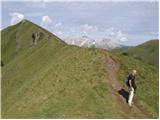 32
32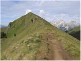 33
33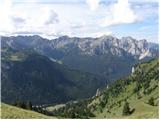 34
34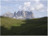 35
35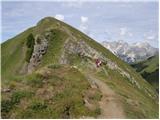 36
36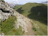 37
37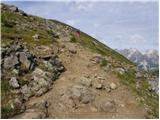 38
38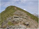 39
39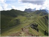 40
40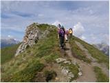 41
41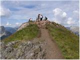 42
42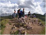 43
43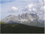 44
44
Discussion about the trip Ciampac - Sas de Adam
To post a comment you must log in:
If you do not yet have a username, you must first
register.