Črni Kal - Blegoš (direct way)
Starting point: Črni Kal (1103 m)
| Latitude/Longitude: | 46,17240°N 14,12430°E |
| |
Route name: direct way
Walking time: 1 h 10 min
Difficulty: easy marked way
Elevation gain: 459 m
Elevation difference along the route: 459 m
Map: Škofjeloško in Cerkljansko hribovje 1:50.000
Recommended equipment (summer):
Recommended equipment (winter): ice axe, crampons
Views: 156.773
 | 8 people like this post |
Access to starting point:
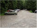
A) First, we drive to Škofja Loka, and then we continue driving towards Gorenja vas. Before we get to Gorenja vas, at the traffic-light intersection we turn right towards Poljane nad Škofjo Loko, then we follow the signs for the settlement Javorje. The ascending road takes us higher to the mentioned village, then at the next crossroads we follow the signs for Blegoš. Further on, we drive on a narrower but still asphalted road. After the settlement Gorenja Žetina the asphalt ends, and only a few minutes of transverse ascent separate us from Črni kal, where there is a larger parking lot and an intersection of several roads.
B) From Žiri, Sovodenj or Horjul we drive to Gorenja vas, and then we continue driving towards Škofja Loka. A little after Gorenja vas, at the traffic-light intersection we turn left towards Poljane nad Škofjo Loko, then we follow the signs for the settlement Javorje. The ascending road takes us higher to the mentioned village, then at the next crossroads we follow the signs for Blegoš. Further on, we drive on a narrower but still asphalted road. After the settlement Gorenja Žetina the asphalt ends, and only a few minutes of transverse ascent separate us from Črni kal, where there is a larger parking lot and an intersection of several roads.
C) From Železniki we drive towards Podbrdo, and then before the settlement Zali Log we turn left in the direction of Davča. At the intersection a few hundred meters away, at the confluence of Davča and Muštrova grapa, we continue on the left road, which higher leads through the hamlet Potok; behind it, before we cross Matevžkova grapa, we continue sharply left onto the road by which we transversely ascend to the parking lot at Črni kal.
D) From Petrovo Brdo or Sorica we descend to Podrošt, and then we continue driving towards Železniki. After the settlement Zali Log we turn right in the direction of Davča. At the intersection a few hundred meters away, at the confluence of Davča and Muštrova grapa, we continue on the left road, which higher leads through the hamlet Potok; behind it, before we cross Matevžkova grapa, we continue sharply left onto the road by which we transversely ascend to the parking lot at Črni kal.
Route description:
From the parking lot, we head onto the road, above which it is written "from here on we walk on foot". Right at the mentioned sign, the signs for Blegoš direct us to the right onto a wide footpath, which already after a few meters crosses a forest road that leads towards the mountain hut on Blegoš.
We continue on the footpath, which starts to ascend steeply through the forest. Higher, the still steep path brings us to the vegetated northeastern ridge of Blegoš, along which we then ascend for quite some time. The path ahead leads us past an old military bunker, above which we soon reach a mini viewpoint, from which a beautiful view opens up onto the nearby Ratitovec.
At the viewpoint the steepness eases, and the path after 5 minutes of further walking brings us out of the forest onto an indistinct little saddle between Špik (1538 m) on the left and Blegoš on the right. Here the path turns slightly to the right and after a few further steps brings us to the panoramic summit ridge. There follows only a short walk past old military trenches to the top of Blegoš, which we reach after a further few dozen steps.

Photos:
 1
1 2
2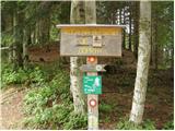 3
3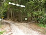 4
4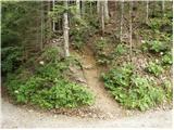 5
5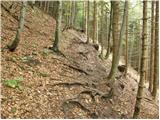 6
6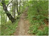 7
7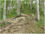 8
8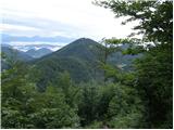 9
9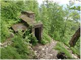 10
10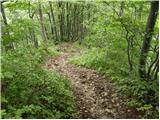 11
11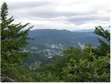 12
12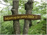 13
13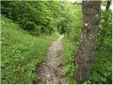 14
14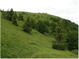 15
15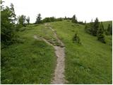 16
16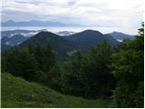 17
17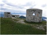 18
18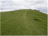 19
19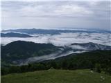 20
20 21
21
Discussion about the trip Črni Kal - Blegoš (direct way)
|
| Gost6. 06. 2007 |
Blegoš is a beautiful vantage point from which you can see a good part of western Slovenia. The cows also enjoy it.
|
|
|
|
| Gost2. 01. 2008 |
Cows not only enjoy it. I see in the picture above they are even licking. Joke aside. Curious how the road to Črni Kal is in winter? Do they plow it or not?
|
|
|
|
| AndrejG30. 08. 2008 |
But from Zale log can one reach Črni Kal by road?
|
|
|
|
| igva31. 08. 2008 |
Of course one can get there. If coming from Železniki, then shortly before Zal log turn left towards Davča and then just follow the signposts that lead to Črni Kal.
|
|
|
|
| mstrman27. 05. 2009 |
Roman.M 07.05.2009
Today I was at Blegoš, weather super, went directly from Črni Kal to Blegoš, the path is really a bit steep approx. 1h walk, but super, the hut is already open also during the week, so beer fits right, down I went by the road a bit around. It was fantastic.
|
|
|
|
| Murglovc9. 05. 2009 |
Blegoš has been snow-free for some time.
|
|
|
|
| klavdy69. 05. 2009 |
I was on Blegoš today, no nice views due to cloudiness. Nevertheless, it was a nice trip. There is almost no snow left, only in the ditches.
|
|
|
|
| zamet3. 12. 2009 |
That's how Blegoš bathed in the sun today..
|
|
|
|
| jakobk25. 04. 2010 |
is there still some snow up there because on Friday it was supposed to snow up there
lp
|
|
|
|
| wolphgang15. 01. 2011 |
Yesterday I was on Blegoš from Črni Kal via the direct path. I don't recommend it, because the steepest part is icy. Otherwise great view.
|
|
|
|
| GregorC4. 05. 2011 |
I'm wondering if anyone knows what condition the road to Črni Kal from Zale loga is in?
|
|
|
|
| katty10. 08. 2011 |
Hi.
Today after half a year I went to Blegoš again. On the steep path. The path is quite steep right from the start , and requires more effort. Along the way we can observe some bunkers that remind of the Rupnik Line. If we step on one of them, an excellent view opens up to nearby Ratitovec, Porezen, Soriško planina and Bohinjske hribe. After about 15-20 min we reach a plain where we can already breathe more easily. To the top we have another 5 or less than 10 min walk. The summit of Blegoš enchants us with a magnificent view of the surrounding hills, Kamniško-Savinjske Alpe and Karavanke, in good weather we can also observe Triglav (today unfortunately I didn't have the opportunity to see it , and requires more effort. Along the way we can observe some bunkers that remind of the Rupnik Line. If we step on one of them, an excellent view opens up to nearby Ratitovec, Porezen, Soriško planina and Bohinjske hribe. After about 15-20 min we reach a plain where we can already breathe more easily. To the top we have another 5 or less than 10 min walk. The summit of Blegoš enchants us with a magnificent view of the surrounding hills, Kamniško-Savinjske Alpe and Karavanke, in good weather we can also observe Triglav (today unfortunately I didn't have the opportunity to see it ). Incredibly, the view of Ratitovec or Krekova koča surprised me the most, which is right in front of us and we could almost grab it ). Incredibly, the view of Ratitovec or Krekova koča surprised me the most, which is right in front of us and we could almost grab it  . As already mentioned, there are many bunkers on the top that remind of the border between fascist Italy and then Yugoslavia. I continued the path to the hut, where I treated myself to excellent tea and pretzels that restored my strength. I returned to the car on a wider path that winds under the hut. The path is intended (hope I'm not wrong) for mountain bikers, but today it was completely torn up as they probably intend to widen it. After approx. 45 minutes I returned to the starting point where my steel horse was waiting. . As already mentioned, there are many bunkers on the top that remind of the border between fascist Italy and then Yugoslavia. I continued the path to the hut, where I treated myself to excellent tea and pretzels that restored my strength. I returned to the car on a wider path that winds under the hut. The path is intended (hope I'm not wrong) for mountain bikers, but today it was completely torn up as they probably intend to widen it. After approx. 45 minutes I returned to the starting point where my steel horse was waiting.
In summary, the trip is also suitable for young families, which I met quite a few today.
Nice sunny greetings...Katy
|
|
|
|
| MOJČ19. 08. 2011 |
With my girls (6,9) I was today on Blegoš via this path. We really "gnawed our knees", but it went. At the top disappointment crept onto their faces too, as there was no stamp anywhere. Together with others we searched for it, but unfortunately didn't find it. We descended past the hut on Blegoš and asked there about it. The caretaker explained that the stamp is welded somewhere below the summit plaque and he was a bit annoyed because many don't find it. That's all about that, it was nice though. Best regards!
|
|
|
|
| Daniyel4. 09. 2011 |
The trail is physically demanding as the ascent is constant almost to the top where it flattens slightly below the summit.
A few more photos from yesterday's hike.
|
|
|
|
| Daniyel4. 09. 2011 |
PS: photos are in the profile of course.
|
|
|
|
| GregorC8. 01. 2012 |
And who knows in what condition the road Potok - Črni Kal is? Is it better to go to Črni Kal via Javorje and Žetine?
|
|
|
|
| KristinaG8. 01. 2012 |
It's better if you go via Žetine.
|
|
|
|
| GregorC22. 01. 2012 |
Yesterday afternoon I went up this path and back past the hut. The path is icy, but little snow. There was also very strong wind blowing.
|
|
|
|
| Boblak39. 04. 2012 |
I'd just warn that at the parking lot at Črni Kal they break into cars so don't leave any wallets in the car!
|
|
|
|
| VanSims12. 05. 2012 |
Today went to Črni Kal via the path from Potok (from Železniki onwards and junction from the main road towards Davča and Cerkno and further over the bridge - NOT right before it). The path is in good condition (May 2012) and should not cause major problems for those used to slightly more difficult accesses to the starting point. The harder part at the end (gravel) is about 3 km long.
|
|
|
|
| Majdag10. 02. 2013 |
...Up this path, back past the hut and also down the "direct" way. Descent to the road very fast. But an icy cold wind was blowing, quite a few visitors. Beautiful winter idyll..
|
|
|
|
| scorpio26. 03. 2013 |
On Saturday with my girlfriend up the direct path in the snow and descent past the hut. Still over a meter of snow. Unfortunately no views, but the menacing curtain of clouds and occasional snow was something special.
Tea in the hut was heavenly good... already because it was hot
|
|
|
|
| Borut117. 02. 2015 |
Wonderful path, there wasn't much snow yesterday. Attaching some photos.
|
|
|
|
| Borut117. 02. 2015 |
Photos are in the 'Current conditions' section
|
|
|
|
| KARAMELICA6. 12. 2015 |
We were today on Blegoš. Went from Črni Kal on the left side. In the valley nice weather, the higher towards the top, the more it blew. At the top wind very strong, fog and cold. On trees and on the board at top marking mountain directions 10 cm rime. When descending to hut a bit better. Hut open, super pork scratchings, and tea.....
|
|
|
|
| saram3. 05. 2020 |
Today went on this path with small children. Path wet otherwise nice. Wind accompanied us all the way. Returned past the hut. Many visitors. Both paths without issues.
|
|
|
To post a comment you must log in:
If you do not yet have a username, you must first
register.