Starting point: D Postaja (2202 m)
| Latitude/Longitude: | 46,33260°N 13,53840°E |
| |
Walking time: 2 h 45 min
Difficulty: very difficult marked way
Elevation gain: 369 m
Elevation difference along the route: 600 m
Map: Julijske Alpe - zahodni del 1:50.000
Recommended equipment (summer): helmet
Recommended equipment (winter): helmet, ice axe, crampons
Views: 18.113
 | 3 people like this post |
Access to starting point:
a) From Kranjska Gora, we drive via the Vršič or Predel pass to Bovec, where we park at the lower station of the circular cabin cable car to Kanin (the cable car is located near the gas station). Then we buy a ticket and take the cable car to the D station.
b) From the Primorska side, we first drive to the Soča river valley and then through Tolmin and Kobarid to Bovec, where we park at the lower station of the circular cabin cable car to Kanin (the cable car is located near the gas station). Then we buy a ticket and take the cable car to the D station.
Route description:
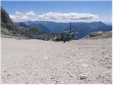
At the D station of the cable car on Kanin, continue slightly left towards the northwest (direction Visoki Kanin and Okno v Prestreljeniku, right Prestreljenik). Initially walk on relatively flat terrain which is still part of the ski slope. The path leads past some information boards then the markers direct to the trail towards Visoki Kanin and Okno v Prestreljeniku (slightly left Dom Petra Skalarja na Kaninu).
The path runs over rocky terrain for a short time then in a gentle ascent crosses scree slopes and leads to a junction.
Here the path to the window branches off to the right, we continue straight on a gradually steeper and moderately difficult path, where some fixed protections assist. When the steepness eases we reach the pass south of Hudi Vršič, the path begins to descend. After some 10 steps of descent we reach a marked junction on the pass below Hudi Vršič, where the path leading past Dom Petra Skalarja na Kaninu joins from the left.
Continue straight in the direction of Visoki Kanin, the path then crosses slopes on the southern side of the border ridge for some time. A somewhat steeper ascent on rocky terrain towards the ridge follows, where a nice view towards Montaž and Viš opens. The path on the slightly exposed ridge then proceeds towards the west and some fixed protections assist. A short descent with the aid of fixed protections towards Kaninska škrbina follows and then another ascent towards the ridge. A little below the summit of Visoki Kanin a somewhat more demanding path from the Italian side joins from the right. To the summit only a short ascent on the panoramic ridge remains.
From the summit of Visoki Kanin descend slightly on the somewhat exposed ridge running south to southwest. The ridge then turns slightly left and a short ascent on the ridge to the summit follows. In the last section of the path some additional caution is needed as the path on the ridge from Visoki Kanin onwards is not protected.
D station - junction to Dom Petra Skalarja 0:10, junction to Dom Petra Skalarja - junction to Prestreljeniško okno 0:10, junction to Prestreljeniško okno - junction below Hudi Vršič 0:20, junction below Hudi Vršič - Kaninski Vršič 1:25, Kaninski Vršič - ferrata Julia junction 0:15, ferrata Julia junction - Visoki Kanin 0:10, Visoki Kanin - Mali Kanin 0:15.

Along the route: Odcep k Domu Petra Skalaraja (2242m), Odcep k Prestreljeniškemu oknu (2302m), Razpotje pod Hudim Vršičem (2376m), Kaninski Vršič (2515m), Kaninska škrbina (2495m), Priključitev ferate Julia (2535m),
Visoki Kanin (2587m)
Photos:
 1
1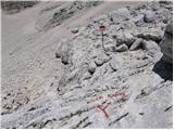 2
2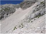 3
3 4
4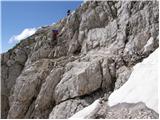 5
5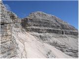 6
6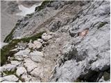 7
7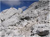 8
8 9
9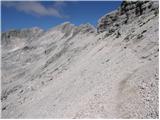 10
10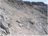 11
11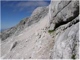 12
12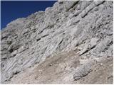 13
13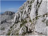 14
14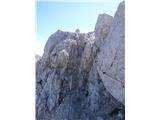 15
15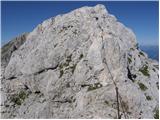 16
16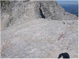 17
17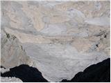 18
18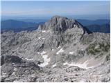 19
19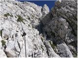 20
20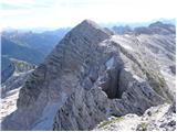 21
21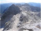 22
22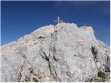 23
23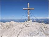 24
24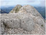 25
25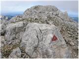 26
26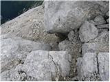 27
27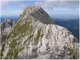 28
28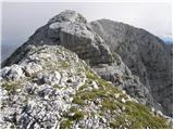 29
29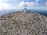 30
30
Discussion about the trip D Postaja - Mali Kanin
|
| katty29. 09. 2011 |
For all who want to go to Mali and Veliki Kanin and Rombon this weekend , and would use the cable car for each ascent, I inform you that within the summer season this time the cable car operates for the last time , and would use the cable car for each ascent, I inform you that within the summer season this time the cable car operates for the last time . Both days, Saturday and Sunday, the first one goes up at 8 (then it repeats every hour), the last one goes down at 16. . Both days, Saturday and Sunday, the first one goes up at 8 (then it repeats every hour), the last one goes down at 16.
This is the latest information.
Regards
|
|
|
|
| katty29. 09. 2011 |
Yes, I also got a link from miri-ja, which says that. Then I just sent an email, and they replied like that. I can forward it in full if there's any interest.
For transport, I might arrange it more precisely today, otherwise we'll hear from each other tomorrow via ZS.
|
|
|
|
| Matjaz_655. 08. 2018 |
a few more of my photos ... otherwise also with continuation along this high rosojanski path to the saddle a bit further from pod kaninom 
|
|
|
To post a comment you must log in:
If you do not yet have a username, you must first
register.