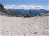
Starting point: D Postaja (2202 m)
| Latitude/Longitude: | 46,33260°N 13,53840°E |
| |
Walking time: 2 h 30 min
Difficulty: very difficult marked way
Elevation gain: 385 m
Elevation difference along the route: 750 m
Map: Julijske Alpe - zahodni del 1 : 50.000
Recommended equipment (summer): helmet
Recommended equipment (winter): helmet, ice axe, crampons
Views: 104.854
 | 4 people like this post |
Access to starting point:
a) From Kranjska Gora, we drive over Vršič or Predel pass to Bovec, where we park at the lower station of the circular cable car to Kanin (the cable car is located near the gas station). Then we buy a ticket and take the cable car to D station.
b) From the Primorska side, we first drive to the Soča river valley and then through Tolmin and Kobarid to Bovec, where we park at the lower station of the circular cable car to Kanin (the cable car is located near the gas station). Then we buy a ticket and take the cable car to D station.
Route description:
At the D station of the Kanin cable car, we continue slightly left towards the northwest (direction Visoki Kanin and Okno v Prestreljeniku, right Prestreljenik). Initially, we walk on relatively flat terrain that is still part of the ski slope. The path leads us past some information boards, then the markers direct us to the trail towards Visoki Kanin and Okno v Prestreljeniku (slightly left Dom Petra Skalarja na Kaninu).
The path runs over rocky terrain for a short time, then gently ascends crossing scree slopes and brings us to a junction.
Here, the path to the window branches off to the right, we continue straight on a gradually steeper and somewhat demanding path, where some fixed protections assist us. When the steepness eases, we reach the saddle south of Hudi Vršič, and the path begins to descend. After a few dozen steps of descent, we reach a marked junction on the saddle under Hudi Vršič, where the path joins us from the left, leading past Dom Petra Skalarja na Kaninu.
We continue straight towards Visoki Kanin, the path then crosses the slopes on the southern side of the border ridge for some time. A somewhat steeper ascent follows on rocky terrain towards the ridge, where a nice view opens towards Montaž and Viš. The path along the slightly exposed ridge then proceeds westwards, aided by some fixed protections. A short descent with fixed protections follows towards Kaninska škrbina and then another ascent towards the ridge. Just below the summit of Visoki Kanin, a somewhat more demanding path from the Italian side joins us from the right. To the summit, only a short ascent along the panoramic ridge remains.
D station - junction to Dom Petra Skalarja 0:10, junction to Dom Petra Skalarja - junction to Prestreljeniško okno 0:10, junction to Prestreljeniško okno - junction under Hudi Vršič 0:20, junction under Hudi Vršič - Kaninski Vršič 1:25, Kaninski Vršič - junction of ferrata Julia 0:15, junction of ferrata Julia - Visoki Kanin 0:10.

Along the route: Odcep k Domu Petra Skalaraja (2242m), Odcep k Prestreljeniškemu oknu (2302m), Razpotje pod Hudim Vršičem (2376m), Kaninski Vršič (2515m), Kaninska škrbina (2495m), Priključitev ferate Julia (2535m)
Photos:
 1
1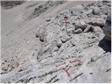 2
2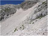 3
3 4
4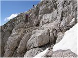 5
5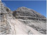 6
6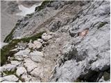 7
7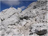 8
8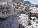 9
9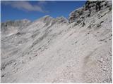 10
10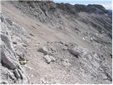 11
11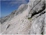 12
12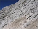 13
13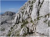 14
14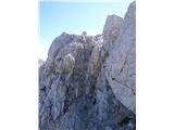 15
15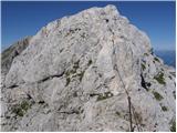 16
16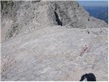 17
17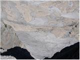 18
18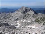 19
19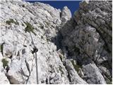 20
20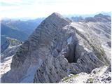 21
21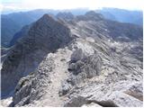 22
22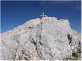 23
23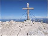 24
24
Discussion about the trip D Postaja - Visoki Kanin
Show older messages
|
| Gost22. 08. 2007 |
The hike is very beautiful, but the last part along the ridge is quite demanding. The path is very well marked, but the ridge section could be better secured in some places. You need to be very careful. I would mark the upper part as a very difficult path!
The view of the vast Kanin meadows is magnificent all the time!!! I definitely recommend it, but according to abilities and wisely. 
|
|
|
|
| Nacek26. 09. 2007 |
Too bad there's no picture...
|
|
|
|
| Gost27. 09. 2007 |
Maybe someone knows if station D also has overnight stays?
|
|
|
|
| Gost30. 09. 2007 |
On 24.8. my husband and I were on Visoki Kanin. It's really a beautiful hike, fantastic views, demanding path. Along the way we visited Prestreljenikovo okno, on the way back we stopped at dom P.Skalarja. We just caught the gondola back at 17:00. Here are some photos, lp Tadeja
|
|
|
|
| Gost30. 09. 2007 |
How do you attach them?
|
|
|
|
| Rok30. 09. 2007 |
For now you can only post images in the current conditions section (forum).
When you open a new thread you can add images after posting the message.
Registered users can post images after every posted message (only valid for the current conditions section).
http://www.hribi.net/trenutnerazmere.asp?novatema=1
|
|
|
|
| soniq27. 07. 2008 |
I agree with the comments below! The tour is very beautiful but should definitely be better secured (due to easy accessibility).....
|
|
|
|
| triglavski27. 07. 2008 |
The safety devices were installed according to standards for very difficult hiking trails, where would we end up if we clad the entire ridge in iron, like on Triglav for example. If you take the cable car up, it doesn't mean you don't need mountaineering experience, proper equipment, and fitness. Almost no one thinks that the cable car can also break down and you'd have to walk down to the valley in that case.
|
|
|
|
| mojcag17. 08. 2008 |
I agree that the trail is sufficiently secured. But you also meet hikers who give the impression that they are first-timers in the mountains. We met a lady who was so scared that she stood "green" in the rocks. On the other hand, my seven-year-old son managed the tour as if it were a joke. True, my husband and I additionally secured him. Definitely experience, equipment and fitness!
|
|
|
|
| davorin17. 08. 2008 |
Beautiful hike and sufficiently secured path.
|
|
|
|
| nenad kastelic9. 06. 2009 |
When does the snow melt on Kanin so that it's possible to bypass Kaninsko pogorje, Rombon ......
|
|
|
|
| mad matheuss30. 06. 2009 |
How is it with this path? Is winter equipment still necessary? Can the snowfield be avoided?
|
|
|
|
| Klin30. 06. 2009 |
There is still a lot of snow on Kanin.
|
|
|
|
| MRKAČ14. 08. 2010 |
Hello,
I'm planning to spend a couple of days on Kanin. I'm interested in what the path from Visoki Kanin towards Laška Planja is like. I haven't seen a description. Is the path exposed or what is the difficulty of the path? Maybe someone knows how long it takes from station D via Visoki Kanin to Laška Planja and to Dom Petra Skalarja?
Thanks to all!
|
|
|
|
| IgorZlodej15. 08. 2010 |
It's part of Visoka Rošojanska pot, mostly exposed ridge climbing grade I, requires experience, no fixed protection. Otherwise, the entire loop can be done in less than 4 hours.
|
|
|
|
| mpolo30. 06. 2011 |
Above all I'd like to ask Igor Z. who supposedly knows the Kanin area like the back of his hand... With colleagues planning a tour from B station of Kanin gondola to peak of Laška Planja, along ridge to Visoki Kanin further to Dom Petra Skalarja and back to B station....
Interested how much time it takes.. we are well physically prepared and used to high altitude hiking... Are conditions from Vrh L. Planja to Visoki Kanin still as you described in the above last year's report.. how's the snow???
Thanks for reply and best regards ....M.
|
|
|
|
| mojcej'724. 07. 2011 |
On 3.7. we completed the tour Postaja D - below Prestreljeniško okno - through Dolge pode - towards Visoki Kanin. There are still some snowfields on the path, the first two or three on the slope are still dangerous for slipping, so carefully (with good boots it's doable). The rest are smaller, a couple of meters or less. The path is well protected on the more demanding sections, but some climbing and gripping rocks without bolts and wire rope is needed, so I personally don't recommend it to those with height problems (children especially not!). On the final sections towards Visoki Kanin there is also some exposed ridge walking in places, which can cause issues for those not secure, so better not risk it.
My partner and I reached the goal without problems, but I was personally disappointed there was no stamp. Apparently someone removed it (the reason for such action probably remains incomprehensible to all of us), but it happens. We also met a group of Czechs (they were mostly well-equipped and fit, so "hats off" this time). The day was sunny, views wonderful, in short super!
|
|
|
|
| FRANC GNEZDA14. 08. 2011 |
12.08.2011, I was at Visoki Kanin. The path is not so badly exposed, but caution is needed. The view was nice. Lots of people. I warmly recommend the path to all who are used to such paths.
|
|
|
|
| pasja_taca25. 07. 2012 |
Hello, I am heading to Visoki Kanin and I am interested if the trail is dry and how it is with the stamp. Thanks for the answer, greetings to all.
|
|
|
|
| neph25. 07. 2012 |
The trail is dry, you get the stamp at Dom Petra Skalarja.
|
|
|
|
| vik25. 07. 2012 |
Is there a passage from Prestreljenik towards Vis. Kanin, or do you have to go back towards station D and then towards Vis. Kanin?
|
|
|
|
| miri25. 07. 2012 |
When you reach the chairlift from the top it is marked - right
|
|
|
|
| NaaN3. 08. 2012 |
How demanding and time-consuming (I found only data that it should take 3h, which seems unrealistic to me) is the trail from station D to Prestreljeniško okno? With how old children have you walked this trail?
|
|
|
|
| miri3. 08. 2012 |
Half an hour. A six-year-old went with me last year. Of course, secured.
|
|
|
|
| miri3. 08. 2012 |
The answer refers to D station-Window. Sorry.
|
|
|
|
| mayda10. 09. 2012 |
Yesterday (Sunday) we were at Visoki Kanin. Already in the buffet at D station they told us there's no stamp at the top and it's at Petra Skalar hut. Unfortunately we couldn't get it there either as the hut was closed at 15:00! It would be right for the stamp to be at the top and it seems strange to me that it's been like this since last year.
|
|
|
|
| ales5010. 09. 2012 |
Yeah, these aren't on the higher peaks anyway, well in the end, if you're registered in the club, you don't need to worry about the stamp, whether it is there or not, what's important is the view and nature,
|
|
|
|
| vavtora29. 08. 2013 |
or does anyone know until what time the gondola operates? thanks for the answer!
|
|
|
|
| irska30. 08. 2013 |
the gondola (since January) no longer operates
|
|
|
|
| vavtora30. 08. 2013 |
Thank you very much for the reply!
|
|
|
|
| marinka6725. 07. 2016 |
The gondola is supposed to start operating again in August, say today's Slo Novice.
|
|
|
|
| pablo29. 09. 2016 |
Finally no more "supposedly". From today the gondola is running again!
|
|
|
|
| seflja9. 09. 2016 |
I'm listening to an ad on the radio, free gondola ride today
|
|
|
|
| adry12. 09. 2016 |
Yesterday after a long time we tried the newly refurbished gondola to D station. It works just like before. Nice! They are still upgrading the other cable cars. Quite a lot of hikers and tourists for this time. They just miss direction signs, they don't know in which direction Kanin is. Also better maintenance regarding waste material around the cable cars and the exit station would be welcome. The weather was rather cloudy but visibility was quite good, so the Koča Petra Skalarja hut and the new bivouac were nicely visible. The cable car will operate only on weekends from 8-16h.
|
|
|
|
| Kemc12. 09. 2016 |
The gondola is running again. Nice. The free ride and nice weather have attracted some visitors. However, I'm not entirely sure why this isn't just throwing big money away.
Before the accident when the gondola was operating, it brought only losses for many years. What has been done at all for the offer so that people would start going there again? Meanwhile, the hotel in Bovec has also gone bankrupt. If there's nothing new there to attract tourists, they'll be selling the entire complex again in a couple of years for peanuts at auction.
|
|
|
|
| joze6228. 09. 2016 |
Is there a stamp at Visoki Kanin now?
|
|
|
|
| matej200028. 09. 2016 |
There isn't, just a logbook without a working pen.
|
|
|
|
| marinka6729. 09. 2016 |
What do you think, is this trail more demanding than Raduha? (of course I mean the demanding one from Grohota)  We managed that without major difficulties but returned via the easier one. It's the descent that concerns me a bit. Thanks. We managed that without major difficulties but returned via the easier one. It's the descent that concerns me a bit. Thanks.
|
|
|
|
| ljubitelj gora29. 09. 2016 |
This trail deserves the rating of demanding marked trail more, there are some trails under very demanding that are substantially longer and more demanding.
|
|
|
|
| marinka6730. 09. 2016 |
Thanks, ljubitelj, so we don't need to fear the descent? We are such a funny group, very young and inexperienced and old and already infertile.
|
|
|
|
| ljubitelj gora30. 09. 2016 |
The trail is not easy, it is demanding, if you are not used to such trails, then wait.
|
|
|
|
| navdušena2. 06. 2017 |
Has anyone been up there this year? Is the path still under snow?
|
|
|
|
| MANGRT2. 06. 2017 |
Last Sunday I was from the Italian side, but the view of the Slovenian side didn't look good.
|
|
|
|
| joze6214. 07. 2017 |
Is there now a stamp at Visoki Kanin?
|
|
|
|
| miri14. 07. 2017 |
Yesterday one female hiker searched for it in vain.
|
|
|
|
| bos14. 07. 2017 |
The reserve stamp should be in the hut which is closed. But at Bovec TIC they have the Prestreljenik stamp and some stamps from nearby peaks.
|
|
|
|
| joze6210. 08. 2017 |
The stamp can be obtained at the Prestreljenik restaurant at D station.
|
|
|
|
| franc gnezda@.com10. 08. 2017 |
I was also on Visoki Kanin today. Despite not the best weather, there were lots of people.
|
|
|
|
| turbo10. 08. 2017 |
Tours are commented on here, that's why photos can't be uploaded. You have to post your tour in Forum -Conditions, where you can also upload photos.
|
|
|
|
| orchidlily2. 09. 2017 |
The cable car ride is a delightful experience in itself, and the trail to the top is just right so you don't tire out, at least not too much - depending on your fitness level . The view of Montaž is magical!
https://www.youtube.com/watch?v=DyU4Fl6YfPY
|
|
|
|
| mornar2. 07. 2018 |
I'm curious about the conditions on the path to Kanin and whether there is a stamp at the top L. P.
|
|
|
|
| mornar2. 07. 2018 |
I'm curious about the conditions on the path to Kanin and whether there is a stamp at the top L. P.
|
|
|
|
| PlaRinka21. 07. 2018 |
I join the sailor's question and would be very happy for an answer.
|
|
|
|
| Jakacius1. 08. 2018 |
Yesterday, 31.7., I was up there. Conditions are summery.
The stamp is still not at the top, but you can get it at the restaurant at D postaja, as joze62 already wrote.
|
|
|
|
| Matjaz_655. 08. 2018 |
a few more of my photos ... otherwise also with continuation along this high rosojanski path to the saddle a bit further from pod kaninom 
|
|
|
|
| stella18. 08. 2018 |
I'm interested if the trail from Visoki Kanin descent to Zadnji dol and further to Veliki dol, and ascent back to Dom Petra Skalarja is marked. Start and end of the tour at station D. Possibly approximate timetable. Thanks.
|
|
|
|
| sh19. 08. 2018 |
We hiked this trail two years ago and it was freshly marked from Mali dol to the Dom Petra Skalarja hut. The markings from Mali dol to the top of Kanin were already quite old, but still traceable. We went in the opposite direction to the one you're asking about.
|
|
|
|
| tenorist19. 08. 2019 |
Hello,
I'm also heading to Visoki Kanin, so please tell me where the stamp is located?
Thanks for your help
|
|
|
|
| sh19. 08. 2019 |
Last year it was in the Prestreljenik restaurant. Maybe now also at the summit.
|
|
|
|
| garmont19. 08. 2019 |
It's still in the D station restaurant (on the counter).
|
|
|
|
| tenorist19. 08. 2019 |
Is that stamp the correct one for the extended Slovenian mountain trail?
|
|
|
|
| Afrofeet26. 08. 2019 |
Does anyone know if this time estimate is realistic? D-station to Visoki Kanin 2.5 hours? I'm planning in September and I'm interested in how much time is needed for the tour.
|
|
|
|
| bos26. 08. 2019 |
Yes, normal walking pace.
|
|
|
|
| sh26. 08. 2019 |
The cable car to Kanin is supposed to operate only until 15.9.
|
|
|
|
| Afrofeet27. 08. 2019 |
Until 15.9? why? Is there no ski season? What's the condition of the cable car?
|
|
|
|
| mirank27. 08. 2019 |
They reopen for the skiing season - when enough snow falls
|
|
|
|
| Afrofeet12. 09. 2019 |
Is the cable car operating on Sunday 15.9?
|
|
|
|
| mirank12. 09. 2019 |
It says it operates until 15.9.; followed by renovation until the winter ski season.
|
|
|
|
| Afrofeet13. 09. 2019 |
I've opened this page about 100 times, and I only see the daily operating hours, nowhere did I find data that it operates until 15.9.
OK, thanks for the information.
|
|
|
|
| sh13. 09. 2019 |
Now it's stated and published on their website.
|
|
|
|
| MasterComputer22. 02. 2020 |
Žiga is no longer at the bar, or rather I don't see where he is...
|
|
|
|
| GregorC22. 02. 2020 |
Over the summer it was at the counter of Ski bum bar.
|
|
|
|
| B223. 02. 2020 |
The stamp and summit logbook for Kanin are managed by PD Bovec, not the taverns in the ski area. Ask the president of PD Bovec (on the website after PZS publication) phone (041) 722 601.
|
|
|
|
| barbara2411. 07. 2020 |
No one answers at the previously mentioned number (called several times). No one knows where the stamp for V. Kanin is, I somewhat doubt that there isn't one because they steal it (opinion at the info point in Bovec). Personally, I think that since V. Kanin is in the transfer zone (V. Kanin or Rombon), they could really take care of the stamp by now because as I read it hasn't been there for a while.
|
|
|
|
| padez12. 07. 2020 |
Try the contact number of the president of PD Bovec (Robert Rot)
(031) 460 474. This information is published on the PZS website. They could also tell you this information at TIC Bovec...
|
|
|
|
| jozee12. 07. 2020 |
I think that PZS and its subordinate mountaineering associations have a very negligent attitude towards stamps on their Slovenian mountain trail. The problem is also in the time when the huts are closed, you cannot get information on where the stamp is (you don't know where to look). Can't they make some order?
|
|
|
|
| Mundek20. 07. 2020 |
Hello.
Today I visited Prestreljenik, where there was no stamp. I asked about the stamp in the Ski Bum bar on Kanin. They have stamps for both Prestreljenik and Visoki Kanin there. Information from today. Regards
|
|
|
|
| Ojgn122. 07. 2020 |
Best regards
In the first week of August I'm heading with my sons 13 and 17 years to Visoki Kanin. Since the description mentions cables I'd ask if mandatory equipment is climbing harness, lanyard? Thank you and best regards
|
|
|
|
| JORDAN23. 07. 2020 |
Self-belay kit is not mandatory nor recommended, since there are few spots where one could belay. The protections are only auxiliary. Just slowly and carefully.
|
|
|
|
| garmont23. 07. 2020 |
But do have helmets...
|
|
|
|
| Ojgn123. 07. 2020 |
We have helmets, thanks for the answer. lp
|
|
|
|
| Laščan8. 08. 2020 |
As much snow as you see in picture no. 5 (about 5 m) there was still last Tuesday.
|
|
|
|
| rokeg8. 08. 2020 |
Today there was no snow on the path.
|
|
|
|
| Matekdd25. 07. 2021 21:40:07 |
Today was on Kanin, almost no snow on the path anymore except on a few harmless sections. The cable car can also be paid with Tano vouchers.
|
|
|
|
| gams197514. 08. 2021 15:01:09 |
Yesterday I was on V.Kanin and M.Kanin and to Koča Petra Skalarja! No stamp at the top, hut and bivouac are closed! The same for the wooden hut above D postaja KŽ and in D postaja KŽ no stamp! Wooden hut open, you can quench your thirst and get something to eat
Regarding the stamp I also checked at TIC Bovec, unfortunately no stamp! They have three stamps from Juliana Trail.
|
|
|
|
| J.P.12. 09. 2021 19:52:23 |
Koča P.Skalarja is falling apart. The bivouac is locked, I couldn't assess if it would even be usable with the key
|
|
|
|
| dragon12. 09. 2021 20:17:59 |
How is the hut falling apart if they just renovated it?
|
|
|
|
| J.P.13. 09. 2021 17:38:39 |
Looks like everything has stopped and is falling apart... when was it last open?
|
|
|
|
| mirank13. 09. 2021 19:55:58 |
Bovčani already have experience with this ; similar happened years ago with Mangrtska koča. ; similar happened years ago with Mangrtska koča.
|
|
|
|
| bongo13. 09. 2021 20:02:56 |
The hut has been closed since 2013, owner is Bovec municipality, which together with PD Bovec and Sončni Kanin rented it to cavers. They are now renovating as best they can with their means (probably not wealthy) and available time, which with thousand caves around remains who knows how much Started practically from scratch, cableway engine didn't work even last year. Given how long PD Bovec takes to deliver a simple stamp to Visoki Kanin, it will surely open sooner than under old management
|
|
|
|
| smatjaz14. 09. 2021 15:47:49 |
.....also the stamp at the top of Prestreljenik
|
|
|
|
| ožep26. 07. 2022 17:35:26 |
On Saturday 24.07.2022 I was on Veliki Kanin. I went past the Perta Skalar hut, which they are diligently renovating. A friendly worker told me, in response to my question how long the hut has been closed, that since 2015 and that cavers have now taken matters into their own hands. I didn't ask when it will open.
At the top of Kanin, unfortunately there is still no stamp, and the cross could also be renovated, as there are very nice crosses or plaques on various peaks, not a wooden pole standing there with some flags on it, to not say rags.
|
|
|
|
| felix23. 08. 2022 13:42:57 |
There are several peaks named Vršič in the ridge. Does this trail go over any of them, or does it go below them?
|
|
|
|
| mirank23. 08. 2022 14:35:01 |
The trail goes below them...
|
|
|
|
| julya23. 08. 2022 17:32:27 |
I think the trail only goes over Kaninski vršič.
|
|
|
|
| BT8823. 08. 2022 21:00:30 |
Don't dirty the prayer flags on Kanin, Ožep. What kind of folk is that.
|
|
|
|
| Janez Seliškar24. 08. 2022 08:05:37 |
"ožep", I'd pick up that junk on the summit and throw it in the trash can at home.
|
|
|
|
| djimuzl24. 08. 2022 11:47:43 |
Or let her "throw" it in Nepalese Kathmandu, one of the few cities in the world where they don't persecute Tibetan "junk" or culture.
|
|
|
|
| miri25. 08. 2022 17:33:27 |
Isn't that, djimuzl, a bit uncultured?
|
|
|
|
| Janez Seliškar25. 08. 2022 18:12:42 |
"Peace", but hanging such and various pieces of textiles on the summits is cultural!
|
|
|
|
| mirank25. 08. 2022 19:46:05 |
I like best to see that there's nowhere to hang them
|
|
|
|
| miri25. 08. 2022 20:01:35 |
|
|
|
|
| dprapr25. 08. 2022 20:45:32 |
Then it would be best if there were no pitons either, so we wouldn't "hang" on them.
|
|
|
|
| turbo25. 08. 2022 21:07:11 |
"Tibetan prayer flags are used to bless the surroundings, promote peace, wisdom, compassion. The five colors on the flags symbolize the five elements. Each one has a drawn symbol and written mantras, prayers, and blessings for the one who hangs the flag. The wind blowing through the flags spreads harmony, blessings, peace from them, and everything written and drawn on them will benefit all beings in the surroundings. When the color on the fabric fades over time, the flags must be burned and replaced with new ones. According to tradition, the best time to hang them is in the morning in sunny windy weather."
|
|
|
|
| felix12. 09. 2022 10:00:26 |
Does anyone know how long the cable car runs in September? On their website there's only the operating hours, not when it will stop running.
|
|
|
|
| mirank12. 09. 2022 12:32:45 |
Usually it ran until 15.9.; call and ask.
Otherwise there's a cable car on the Italian side too, for almost half the money it takes you to Rifugio Gilberti - check if it's still running! because they don't operate all the time there either
|
|
|
|
| felix31. 07. 2024 14:58:47 |
Does anyone have any information about the cable car to Kanin? Is it running, will it run, if so - when?
|
|
|
|
| miri31. 07. 2024 15:22:38 |
I think some of us here are too old to ride it.
|
|
|
|
| turbo31. 07. 2024 15:37:22 |
|
|
|
|
| mirank31. 07. 2024 17:39:20 |
Mirč, we might still be able to ride it, but walking further will probably be a problem for us then
|
|
|
|
| glorija23. 04. 2025 13:19:23 |
Heard from PD Bovec that they will install the stamp at the top of Kanin when conditions are right.
|
|
|
|
| simon1616. 09. 2025 19:26:23 |
I can confirm there is a stamp at the top. Verified yesterday.
|
|
|
To post a comment you must log in:
If you do not yet have a username, you must first
register.