Dajčpeter / Deutcher Peter - Ferlacher Horn / Grlovec
Starting point: Dajčpeter / Deutcher Peter (700 m)
| Latitude/Longitude: | 46,47850°N 14,25590°E |
| |
Walking time: 3 h
Difficulty: easy marked way
Elevation gain: 1140 m
Elevation difference along the route: 1140 m
Map: Karavanke - osrednji del 1:50.000
Recommended equipment (summer):
Recommended equipment (winter): ice axe, crampons
Views: 11.619
 | 1 person like this post |
Access to starting point:
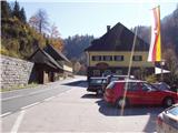
Via the Ljubelj border crossing we drive towards Celovec / Klagenfurt. After the first tunnel, after a good 100 m on the left side we will notice the guesthouse Dajčpeter / Deutcher Peter and behind it a large parking lot, where we park.
Route description:
From the parking lot, we go up the road to the signposts for Grlovec / Ferlacher Horn. Further, we continue on a cart track which ascends alongside the stream upwards. The cart track then turns into a footpath which for some time is still ascending alongside the riverbed, and then turns left and steeply ascends. The path, which ascends quite steeply, a little higher crosses a forest road. We further follow the path which is in parts a little poorly visible but well-marked. The path then brings us to the forest road which we follow for a few minutes to the spot where a footpath branches off left upwards. The path ahead at first steeply ascends, after that the steepness decreases and the path brings us to an overgrown meadow after which we step on the road.
We continue left and then at the crossroads immediately right. Further, we continue on a path that gently ascends parallel with the road all the way to the junction. Soon after the junction the path crosses a clearing and then again starts to ascend more steeply. The path then past a memorial soon brings us to the vantage point from which a view opens up towards the north. The path then ascends through a conifer forest and eventually returns to the ridge. Next follows a walk below the ridge, to which the path only rarely ascends. Where the path gets close to the ridge caution is needed so that we don't slip into a precipice. The forest then becomes thinner and soon in front of us we notice a cross on the top. Follows only a few minutes of panoramic walking on the unvegetated upper slope of the mountain.

Photos:
 1
1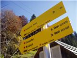 2
2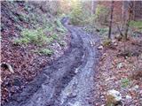 3
3 4
4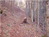 5
5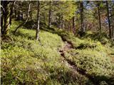 6
6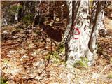 7
7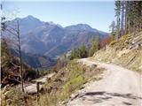 8
8 9
9 10
10 11
11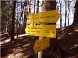 12
12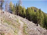 13
13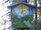 14
14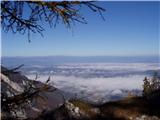 15
15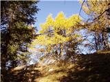 16
16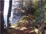 17
17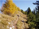 18
18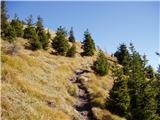 19
19 20
20
Discussion about the trip Dajčpeter / Deutcher Peter - Ferlacher Horn / Grlovec
|
| klm11. 12. 2010 |
There are already such memorial plaques on Karawank summits. Hunting buddies are truly real friends: they drink it together, meanwhile one of them secretly goes for the host's wife, the host then shoots him in gratitude during the joint hunt. Later he excused himself that he mistook him for a roe deer. The story is actually current "deja vu"
|
|
|
|
| darh23. 08. 2012 |
On Sunday we tackled the ascent to Grlovec via this path with a short detour over the interesting saddle Eselsattel. With orientation we mostly had no problems, only at the forest road junction mentioned in the text (pictures 10 and 11), we initially didn't quite find our way. Right at the junction the path merely crosses the road and then first continues under the road, then for a while along it, in the middle of the clearing it finally turns above it too. Detailed description of our path with pictures can be found here.
|
|
|
|
| VanSims23. 08. 2012 |
At Deutcher Peter good party!
|
|
|
|
| klavdipo12. 10. 2013 |
I noticed there is a stamp, is it available at the summit or in the hut? Thanks and best regards!
|
|
|
|
| Tadej12. 10. 2013 |
Last year the stamp was at the summit, whether also in the hut I don't know.
|
|
|
|
| Fulcrum8. 05. 2015 |
Today I walked the described path (No. 603) from Dajčpeter / Deutcher Peter to the summit of Grlovec / Ferlacher Horn in a good two and a half hours. The path is excellently marked and I had no orientation problems. Be most careful at the beginning, as the path follows the road to Ljubelj, which is quite busy. Once the path approaches the ridge there is no slipping danger, of course if you stay on the path. I did not notice the marker by the path (picture No. 14).
|
|
|
To post a comment you must log in:
If you do not yet have a username, you must first
register.