Dol - Stegovnik (via Močnikovo sedlo)
Starting point: Dol (850 m)
| Latitude/Longitude: | 46,38260°N 14,44450°E |
| |
Route name: via Močnikovo sedlo
Walking time: 2 h 30 min
Difficulty: partly demanding marked way
Elevation gain: 842 m
Elevation difference along the route: 842 m
Map: Karavanke - osrednji del 1:50.000
Recommended equipment (summer):
Recommended equipment (winter): ice axe, crampons
Views: 41.536
 | 6 people like this post |
Access to starting point:
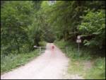
From the Ljubljana - Jesenice highway take the Kranj - east exit and follow the road ahead in the direction of Jezersko, but only to the inn Kanonir, where we turn left. We further follow initially the still asphalted road but only to the approximately 2 km distant crossroad, where the road to Stegovnik branches off to the right. We go on this road, which we follow a few hundred meters to the gate, where we park on a smaller parking lot.
Route description:
From the gate we follow the forest road which after approximately 20 minutes brings us to a crossroad. We go right and follow the road further to a bigger grassy clearing on which a house stands. Here we go straight on the footpath following the signs for Stegovnik (left Stegovnik through the window, unmarked path). The path ascends a little and brings us to a cart track. Here we carefully look for the blazes and take care that the cart track does not mislead us. The path then crosses the cart track a few more times and brings us to Močnikovo sedlo together with the cart track.
Here on the saddle we go sharply left and on a wide path already after a few steps we come to the next junction. We go left again in the direction of Stegovnik. The path soon brings us to another cart track. This is the cart track along which we were walking already before the saddle. We follow this cart track for approximately 5 minutes to the spot where the path to Stegovnik branches off to the right upwards. After the initial ascent the path quickly becomes gentle and in a traverse towards the right brings us to a torrent gully. Here the path starts to ascend steeply beside the torrent, which it crosses in the upper part and brings us to the other side. Here the steepness decreases again and through a nice forest brings us to a saddle named Pri Lojtri.
Next follows an ascent on an initially gentle ridge, which soon becomes quite steep (in wet dangerous for slipping). The path then with the help of a steel cable overcomes the only demanding spot on the path. The path crosses a 3 meters long exposed ledge. After that the path brings us to a less steep ridge which we follow with nice views to the summit which we reach in 10 minutes of additional walking.

Along the route: Močnikovo sedlo (1315m)
Photos:
 1
1 2
2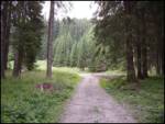 3
3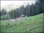 4
4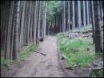 5
5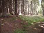 6
6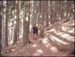 7
7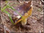 8
8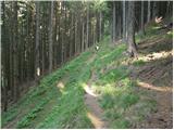 9
9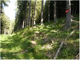 10
10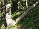 11
11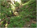 12
12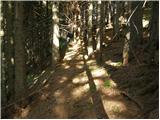 13
13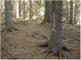 14
14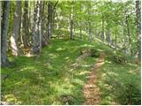 15
15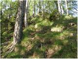 16
16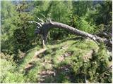 17
17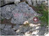 18
18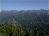 19
19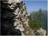 20
20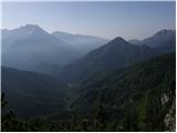 21
21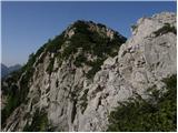 22
22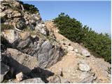 23
23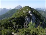 24
24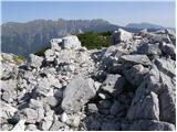 25
25
Discussion about the trip Dol - Stegovnik (via Močnikovo sedlo)
|
| ROBERT22. 08. 2006 |
Beautiful relaxing path, full of pleasant surprises!
|
|
|
|
| Gost26. 08. 2006 |
Little men, true masterpieces.
|
|
|
|
| Gost29. 08. 2006 |
And if you're lucky and have good eyes to spot boletus mushrooms, you can gather your dinner too. At least I had such a pleasant experience. Yes, it's great to wander in the mountains above Jezersko.
|
|
|
|
| Gost18. 09. 2006 |
This is the most beautiful mid-mountain hike for me!! 
|
|
|
|
| Gost25. 05. 2007 |
The norm is a bit exaggerated. I took exactly three hours, and I walk fast. Nowhere are the passages through the wonderful natural windows mentioned. Through the exit one you have to bend down properly. On the summit really wonderful view.
|
|
|
|
| Leon812. 08. 2009 |
The time of 2.5 hours seems too short to me too. Yesterday my wife and I were on this tour and we walked a good 3 hours. Also, the route description in the logbook 'Kranjski vrhovi' states 3 hours. I suggest correcting the time to 3 hours.
|
|
|
|
| Parkeljc24. 06. 2010 |
Hm, "timing" is very relative, I hiked from the gate to the top today in about 1 hour 45 min, and it felt like I was dragging myself... The view is really phenomenal; Košuta, Kočna, Grintovec, Storžič, Javornik, Kozji vrh,... Recommended!
|
|
|
|
| bolhca15. 11. 2010 |
Yesterday my colleague and I did a nice autumn hike on this path and the time will hold. We were from the barrier to the top in less than two and a half hours. But I lost a small camera somewhere on the path in a black leather case. If anyone has found or will find it anywhere on the path, I would be very happy if they send me a message.
|
|
|
|
| Sim7913. 08. 2012 |
Interesting path. However, it is somewhat poorly marked - there are few markings in some places and they are very faded.
|
|
|
|
| metod25. 11. 2012 |
Road closure is valid from 20.7. to 20.10., they attached an additional sign. Today it was pleasant, at the summit warm, no wind and calm. Along the ridge towards the summit, the wires of the former Born's enclosure for deer are still visible. Near the wires I noticed a boundary stone with initials D.J. Does anyone perhaps know what they mean?
|
|
|
|
| peterr25. 11. 2012 |
The boundary stone with initials D.J. is also on the summit of the neighboring Ruš 1614m, when I inquired a few years ago I got the info that there was a large landowner Dolenc in Kokra. On the net I found info that at the beginning of the world crisis after WWI, Franc Dolenc (his father's name was Jože, they come from the Škofloška area where they also had a sawmill on the pasture) and Franc Hajnrich bought most of the estates and sawmills in Kokra. In 1924 he also bought a sawmill in Preddvor (150 workers) and the Hrib castle in Preddvor. In 1929 they bought the Brdo estate together with Hajnrich and sold it in 1935 to Karadžorjevič. Most likely these stones marked the boundary of his estates.
|
|
|
|
| metod25. 11. 2012 |
Peterr, thanks. Nice trip and I learned something new too.
|
|
|
|
| smatjaz15. 10. 2013 |
Lisica, today I visited Stegovnik and I have to say it is an exceptional trip, especially since I climbed through the window and returned via Močnikovo sedlo, as you suggested. The administrator can safely adjust the time to 3 hours, as that is what an average hiker uses for the ascent. Major criticism goes to the Mountaineering Association responsible for these paths, as the markings are in a condition as if made somewhere between World War I and II, and some are missing here and there because foresters felled the tree they were on, so at the holiday cottage there is no marking for the left direction through the window (I didn't find it on any map except hribi.net), later they disappear too, already at the junction from the forest path, all the way to the window!!! On top of everything, pathfinding is hindered by ongoing timber hauling which causes many new paths that can mislead. Lisica, without your description it would have been very difficult - thanks! Given that jerinjan 2009 and bojan a 2010 already warned about poor markings, it is high time for the mentioned PD to take action, as it obviously doesn't realize what a gem it has. Returning via Močnikovo sedlo is a bit easier because the path is more worn as many visitors don't know about the path through the window and use via the saddle. Major criticism goes to the Mountaineering Association responsible for these paths, as the markings are in a condition as if made somewhere between World War I and II, and some are missing here and there because foresters felled the tree they were on, so at the holiday cottage there is no marking for the left direction through the window (I didn't find it on any map except hribi.net), later they disappear too, already at the junction from the forest path, all the way to the window!!! On top of everything, pathfinding is hindered by ongoing timber hauling which causes many new paths that can mislead. Lisica, without your description it would have been very difficult - thanks! Given that jerinjan 2009 and bojan a 2010 already warned about poor markings, it is high time for the mentioned PD to take action, as it obviously doesn't realize what a gem it has. Returning via Močnikovo sedlo is a bit easier because the path is more worn as many visitors don't know about the path through the window and use via the saddle.  I must also thank two friendly young ladies whom I met on the ascent and who helped me with directions on the path. I must also thank two friendly young ladies whom I met on the ascent and who helped me with directions on the path. In spring I will return and do the ascent from the opposite side and extend it to the hut below Storžič. And if the markings are not repaired, I will carry that "kilo" of paint up myself and fix them. In spring I will return and do the ascent from the opposite side and extend it to the hut below Storžič. And if the markings are not repaired, I will carry that "kilo" of paint up myself and fix them. Well, anyone heading up should heed Lisica's advice - it helps. Good luck and safe steps to all! Well, anyone heading up should heed Lisica's advice - it helps. Good luck and safe steps to all!
PS: the criticism of the markers was not malicious, it was just expressed as a wish for something to move in this area, right?
|
|
|
|
| PAJKEC17. 10. 2013 |
I completely agree with smatjaž. The path is wonderful, suitable for everyone and it's really a shame it's so poorly marked. I personally walked with the description in hand. I think now is the right time to visit this mountain, as the golden yellow color of larches in this season further enhances this interesting tour.
|
|
|
|
| som6917. 10. 2013 |
To Močnikovo sedlo I recommend the path from the Rezman farm, where there are still fewer logging tracks.
|
|
|
|
| smatjaz30. 10. 2013 |
som69, maybe true, but then you have to give up the path through the window, which would be a great pity or walk back some time from Kanonir. It would be a shame not to do the circular route. Safe steps to all.
|
|
|
|
| som6930. 10. 2013 |
That doesn't hold, the circular path that runs through the window is above Močnikovo sedlo.
|
|
|
|
| martinkarpan31. 10. 2013 |
Hi, can you tell me where you parked? Because at the barrier it's full of logs and everything is muddy....
|
|
|
|
| Lisica31. 10. 2013 |
I parked at the barrier, but at that time the barrier was up and you could drive further with the car, say to that weekend/house where the junction for the circular trail is. You can also park lower down below the house in Dol-but you'll extend the trail by about 5-10 minutes.
|
|
|
|
| smatjaz1. 11. 2013 |
Martin, I was on the meadow by the road about 100m before the barrier, true that there weren't so many logs then, but mud yes. If you manage to get through the mud with the car, then as Lisica wrote. Or already at the first junction where the road first turns right. Just make sure the vehicle is far enough off the road because of the log hauling.
|
|
|
|
| Andrej-25. 06. 2014 |
On Saturday I set off for Stegovnik via Močnikovo sedlo. I parked above the Lindau farm and started on the path. The path is wide and nice, a bit dragging at first, then it turns into a forest path. All the way to the top it was great and wonderful.
On the way back I decided to go through the window and past planina Javornik. That way I would make a nice loop. There I asked the caretaker for the path in the direction of Kanonir, to get back to the starting point. The friendly caretaker told me to just go through the forest by the hut and keep to the right. But if I had kept only to the right, I would have ended up at the Dom pod Storžičem :-) At least that's what the signs and hikers heading there showed :-)
At that junction I continued on the only possible path to Stegovnik via Močnikovo sedlo, thinking that somewhere it would branch off down. After a few minutes of walking I come to a new sign that nicely marks the path and confirms I chose the right one. However, already after about 100 m the end of the path surprises me, blocked with wire, followed by a steep and impassable slope (down of course). So despite the marked path, it ends and I didn't know where to go next? I decided to go back to check if I missed something, but I didn't. At the wooden shed in the meadow I then continued the path by feel along the slope, through dense and very steep scrub, until I reached a gully, which was dry but extremely unpleasant to walk through :-/
So I traversed the entire gully (about 40 min) and came out onto the road, which then leads to the upper parking lot and further to the lower parking lot with the barrier.
All's well that ends well, just I can't get my head around why this path from planina Javornik towards Kanonir suddenly ends?!?
Does anyone know where I went wrong, maybe overlooked a path? I decided to repeat the ascent, but first I would like to read some useful advice :-)
Thanks!
|
|
|
|
| ljubitelj gora25. 06. 2014 |
From Stegovnik I headed towards Mali Javornik along the S side, from the top I followed the marked path back towards Stegovnik for a while, then directly down into the valley. There is a bit of a problem if you want to go really directly down.
One route I took:
http://shrani.si/f/2f/ac/3JzIUlNx/22222.jpg
|
|
|
|
| dragon5. 08. 2014 |
Andrej, on Sunday I did this trail as you describe it and I can tell you where you went wrong. At Javorniški preval there are two junctions. First one and after a few dozen meters the second one. At both, go straight ahead towards Jezersko. Everything is well marked, lots of signs. After about half an hour you reach the macadam road, which you just cross and continue through the forest for another ten minutes and then rejoin the road leading towards Dol.
I hope I helped you and happy hiking.
|
|
|
|
| Gost7927. 04. 2015 |
Very nice trail (especially the circular one...through the windows), but on some sections poorly marked. Official markings are largely overgrown with lichens and moss or have faded, making them somewhat harder to see.
The barrier is raised (and remains raised - as confirmed by a nearby farmer)...for those who might want to go a bit higher by road. For the period 20.7.-20.10., a complete closure is supposed to apply (sign). The gravel road is also in good condition.
|
|
|
|
| Hahar24. 08. 2015 |
On Saturday we did a "circular" tour from the barrier in Dol, right after the Lindau farm? (on the map: Limdav?). We followed the ban and walked the road to the tourist hut in the clearing. On the way back we saw that some had driven up by car and we regretted not doing it too. The road is 5++! We started over Močnikovo sedlo to the summit. Markings are very good, and the signposts are noticeable and very useful. From the summit we continued along the entire ridge and descended to the window, through the window crossed to the other side. A signpost for Močnikovo sedlo awaited us. We decided to return towards Močnikovo sedlo. The path to M. sedlo is well marked, but we wouldn't recommend it because due to ice/hoarfrost damage it runs jaaaak very low under the old path(?) which is littered with fallen trees. You lose at least 150m height and then have to climb those 150m back up over bad terrain and unbeaten path. It must be admitted that the markers have worked hard, cut the path and marked it nicely , but the route is still really awkward! The host in the tourist hut at the start recommended that on the return we descend to the road, but after the window the road was not visible and we didn't dare descend blindly down the great slope into the unknown mountain. For the whole tour we needed more than six hours - more for descent and return than for ascent! The mountain is really wonderful, a real little gem, but the described "circular" tour is not the best idea!
|
|
|
|
| Batistuta10. 07. 2017 |
Today I went to Stegovnik via the path through Močnikovo sedlo, the path is nicely marked, it took me 1h 50' to the top. At the top I continued ahead (not back the same way) and this path led me to the window. Unfortunately, the window is not marked on the map on this side (but it is marked on the Jezersko and surroundings map 1:25000). The window is totally fascinating, as it has 5 eyes, in my opinion the most beautiful in Slovenia.
The next mistake on the map is that there is no marked walking trail connecting the two marked paths that go towards Javorniški preval (one from the top of Stegovnik, the other from Močnikovo sedlo). So, when coming down through the window, continue on the marked path for 5-8 minutes, then you reach a junction where two paths are marked, one goes right level, but choose the one that goes left upwards. This little path takes you to a marked junction, where you continue towards Močnikovo sedlo. This makes a circular path that is much more interesting, and you also see the window, which is a ''must-see''!
|
|
|
|
| svizec111. 07. 2017 |
I'm wondering if at least 75% of the path to Stegovnik is in shade (in the afternoon, after 2pm!) and thus suitable for these hot days? Or if someone perhaps knows another hill or mountain with approx. 1000 m elevation gain that is 80% in shade in the afternoon and still has a nice view from the top - something like Ciprnik from Jasna (Kranjska Gora)? Thanks
|
|
|
|
| Janezs13. 07. 2017 |
Good, don't ask how many degrees it will be along the path.
|
|
|
|
| siddh22. 04. 2019 |
This trail is no longer recommended. On the way up we got lost despite effort, because around Močnikovo sedlo there is logging that hinders finding markings and also the path (if anyone goes, stick to the far left). The return path (we went circular, from the summit along the ridge, then down and through the window) is, although well marked, really very obstructed - huge number of fallen trees and boulders over which you have to climb or go around.
|
|
|
|
| trdi14. 07. 2019 |
I agree with the predecessor, this circular path is otherwise well marked, the markings look quite new. The trouble is really on this logging area, where they obviously cut down trees with markings, luckily at the end of the logging there's a big cairn that directs you to the marked path, but there are really loads of fallen trees on the path, especially from the window back towards Močnikovo sedlo, so it's quite strenuous.
|
|
|
|
| Zdenkob24. 07. 2020 |
On Monday, July 20, I ascended Stegovnik from Dol through the window, returning via Močnikovo sedlo. The path from Dol through the window is not officially marked, but unofficial markers, the description here, and comments can help. There are some clearings where markers are lost, and many fallen trees that must be bypassed, climbed over, or crawled under - both on ascent and descent. This is likely the reason for the modest visits to this peak, which otherwise offers fine views.
|
|
|
|
| anica.zu14. 10. 2023 12:23:48 |
The trail through the window is completely newly marked.
|
|
|
To post a comment you must log in:
If you do not yet have a username, you must first
register.