Dolina Ropojana - Maja Jezercë
Starting point: Dolina Ropojana (1150 m)
Walking time: 6 h 30 min
Difficulty: very difficult marked way
Elevation gain: 1544 m
Elevation difference along the route: 1544 m
Map:
Recommended equipment (summer): helmet
Recommended equipment (winter): helmet, ice axe, crampons
Views: 5.490
 | 3 people like this post |
Access to starting point:
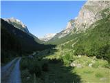
In the center of the town Gusinje (Montenegro), follow the sign for Alipašini izvori. After about one kilometer, shortly after crossing the bridge, turn left towards the village Vusanje (right to Alipašini izvori). Follow the main asphalted road to the end of the village where the road becomes gravel (before the gravel to the right is the Grlja waterfall). The gravel road, which is in poor condition in places, leads us through the Ropojana valley. Along the path (marked by a sign) is the Oko Skakavice spring, worth a stop. Park on the flat part of the valley, about 3 km from the start of the gravel. If the road is in poor condition, park earlier, which extends the route.
Route description:
From the parking lot, continue along the gravel road, which soon turns into a torrent bed. Follow the markers, which partially shortcut the path across the meadow. Follow the torrent to a sign where the path to the Albanian village Theth branches right (6h walk), we continue left along the main track, which soon turns sharply left and starts ascending. There are no markers on this section. Soon the path to Theth branches right again (unmarked), we continue straight along the track, which brings us to Karavla Zastan in about half an hour. In summer, this is a mountain hut where you can refresh with homemade bread and sheep cheese; drinks are also offered. At the hut, you can pitch a tent; in bad weather, you can sleep inside. From the hut, continue straight towards the forest where markers reappear. Soon reach a drinking water spring, then a junction where the path to Maja Rosit branches left (4h), we continue right towards Maja Jezercë. The path ascends quite steeply through the forest. Upon exiting the forest, it levels out and becomes more scenic. Soon reach a destroyed border stone and enter Albania. Then spot the first lakes in the lake valley – Buni i Jezercës. The path runs mostly over grassy terrain between glacial lakes, which dry up in summer. Bypass the last one, the so-called Veliko jezero, on the right side along the slope of Maja Bojs. The path, offering fine views of the lake, gradually steepens to a small pass (Qaf Vogl) behind which is a snowfield; be more careful here as the path is poorly marked. After the snowfield, turn left onto rocky karst terrain that ascends gradually. In the initial part, some easy scrambling is needed. Stone cairns greatly aid orientation. Soon spot the summit for the first time. The path then crosses snowfields and scree, ascending more distinctly again, sometimes in switchbacks, to a scenic saddle (2330 m) below the summit. From the saddle, the final 400 m ascent follows. The path here is over distinctly rocky karst terrain where occasional climbing is required. After about half an hour of walking, reach a snowfield leading to the steepest and most demanding section through the inclined couloir. Due to falling rock hazard, wear a helmet; be cautious also for slipping risk, as the rock is friable with much scree on the path. The path then shifts to the western slope, bringing us via rough scree in about half an hour to the panoramic summit.
Ropojana Valley - Karavla Zastan 1:15h; Karavla Zastan - Veliko Jezero 2h; Veliko jezero - saddle below summit 2h; saddle - summit 1:15h

Along the route: Karavla Zastan (1340m), Veliko jezero (1785m), sedlo pod vrhom (2330m)
Photos:
 1
1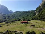 2
2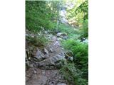 3
3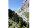 4
4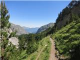 5
5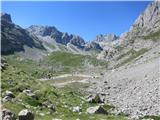 6
6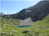 7
7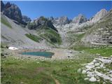 8
8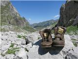 9
9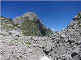 10
10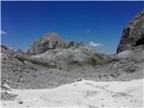 11
11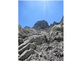 12
12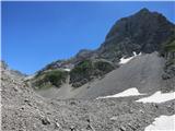 13
13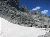 14
14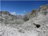 15
15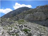 16
16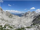 17
17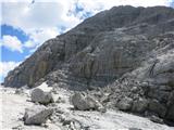 18
18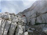 19
19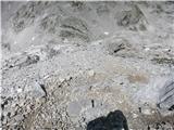 20
20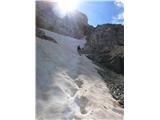 21
21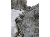 22
22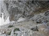 23
23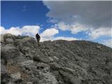 24
24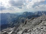 25
25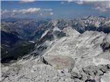 26
26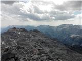 27
27
Discussion about the trip Dolina Ropojana - Maja Jezercë
|
| Trobec17. 08. 2018 |
The marking "partly difficult marked trail" does not match the actual condition (not because such a marking does not officially exist). The trail is at least difficult, probably the ZZ marking is even more appropriate. The terrain is extremely crumbly at some exposed spots, no safety gear.
Just for awareness, so no one takes the trail lightly and is then unpleasantly surprised.
|
|
|
|
| Tadej20. 08. 2018 |
Thanks for the warning. I have changed the difficulty in the description.
|
|
|
To post a comment you must log in:
If you do not yet have a username, you must first
register.