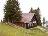
Dom na Gospincu - Veliki Zvoh
Starting point: Dom na Gospincu (1492 m)
| Latitude/Longitude: | 46,29570°N 14,52140°E |
| |
Walking time: 1 h 25 min
Difficulty: easy marked way
Elevation gain: 479 m
Elevation difference along the route: 479 m
Map: Kamniške in Savinjske Alpe 1:50.000
Recommended equipment (summer):
Recommended equipment (winter):
Views: 18.587
 | 3 people like this post |
Access to starting point:
A) From the Ljubljana - Jesenice highway, take the Vodice exit, then continue driving to the first traffic-light intersection in Vodice, where you continue left in the direction of Cerklje na Gorenjskem and Brnik. When you reach the main roundabout in Spodnji Brnik, continue driving in the direction of Cerklje and the Krvavec ski resort. At the end of the settlement of Cerklje na Gorenjskem, leave the main road which continues towards Velesovo and Visoko and continue driving slightly right onto the road in the direction of the Krvavec ski resort. Park on the large well-maintained parking lot by the lower station of the monocable gondola on Krvavec, where you buy a ticket and take the mentioned gondola to the upper station, which is located by the Dom na Gospincu mountain hut.
B) From the Jesenice - Ljubljana highway, take the Kranj - east exit, then continue driving towards Brnik, Komenda and Mengeš. When you reach the main roundabout in Spodnji Brnik, continue driving in the direction of Cerklje and the Krvavec ski resort. At the end of the settlement of Cerklje na Gorenjskem, leave the main road which continues towards Velesovo and Visoko and continue driving slightly right onto the road in the direction of the Krvavec ski resort. Park on the large well-maintained parking lot by the lower station of the monocable gondola on Krvavec, where you buy a ticket and take the mentioned gondola to the upper station, which is located by the Dom na Gospincu mountain hut.
C) From the Ljubljana - Jesenice highway, take the Vodice exit, then continue driving to the first traffic-light intersection in Vodice, where you continue left in the direction of Cerklje na Gorenjskem and Brnik. When you reach the main roundabout in Spodnji Brnik, continue driving in the direction of Cerklje and the Krvavec ski resort. At the end of the settlement of Cerklje na Gorenjskem, leave the main road which continues towards Velesovo and Visoko and continue driving slightly right onto the road in the direction of the Krvavec ski resort. Further on, you reach the village of Grad, where signs for the settlement Ambrož pod Krvavcem direct you right onto a steep asphalt road (straight ahead to the lower station of the monocable gondola on Krvavec and Štefanja Gora). When the gradient on the steep road eases somewhat, you will come to an intersection, where you continue left in the direction of the settlement Ambrož pod Krvavcem (straight ahead to the settlements Ravne, Apno and Šenturška Gora). A little further, the road temporarily descends a bit, then ascends through occasionally quite panoramic slopes. Higher up, you reach Ambrož pod Krvavcem, where you bypass the church of St. Ambrož and the Pr Ambružarju tourist farm on the left side. From the tourist farm onwards, the road enters the forest and ascends through it all the way to the Jezerca mountain pasture, where there is a large well-maintained parking lot. Here the road flattens and turns left, about 500 m further it brings you to an intersection, where you continue slightly left (right to Kriška planina). On the macadam road, you then drive for some time, i.e., to the upper station of the monocable gondola.
The road from the Jezerca mountain pasture to the Dom na Gospincu is now closed to public traffic; this extends the route by approximately 30 minutes.
D) From the Jesenice - Ljubljana highway, take the Kranj - east exit, then continue driving towards Brnik, Komenda and Mengeš. When you reach the main roundabout in Spodnji Brnik, continue driving in the direction of Cerklje and the Krvavec ski resort. At the end of the settlement of Cerklje na Gorenjskem, leave the main road which continues towards Velesovo and Visoko and continue driving slightly right onto the road in the direction of the Krvavec ski resort. Further on, you reach the village of Grad, where signs for the settlement Ambrož pod Krvavcem direct you right onto a steep asphalt road (straight ahead to the lower station of the monocable gondola on Krvavec and Štefanja Gora). When the gradient on the steep road eases somewhat, you will come to an intersection, where you continue left in the direction of the settlement Ambrož pod Krvavcem (straight ahead to the settlements Ravne, Apno and Šenturška Gora). A little further, the road temporarily descends a bit, then ascends through occasionally quite panoramic slopes. Higher up, you reach Ambrož pod Krvavcem, where you bypass the church of St. Ambrož and the Pr Ambružarju tourist farm on the left side. From the tourist farm onwards, the road enters the forest and ascends through it all the way to the Jezerca mountain pasture, where there is a large well-maintained parking lot. Here the road flattens and turns left, about 500 m further it brings you to an intersection, where you continue slightly left (right to Kriška planina). On the macadam road, you then drive for some time, i.e., to the upper station of the monocable gondola.
The road from the Jezerca mountain pasture to the Dom na Gospincu is now closed to public traffic; this extends the route by approximately 30 minutes.
Route description:
At the upper station of the monocable gondola on Krvavec we will notice numerous mountain signposts. We head in the direction of the Dom na Krvavcu hut and Marija Snežna on a poorly visible path, which ascends almost straight up the grassy slope. The poorly visible path higher up leads across a grazing fence, behind which it becomes somewhat more followable. The relatively steep path then brings us to the Dom na Krvavcu hut, which we can already see from the upper cable car station (alternatively possible here also via a poorer macadam road). From the hut, we continue in the direction of Zvoh on the road which takes us past the chapel and transmitters on Krvavec to the Razor saddle (saddle between the Krvavec peak and Veliki Zvoh), where there is a road junction. We continue straight along the ridge (right to Krvavec peak 5 minutes) and follow the increasingly steep transport-rescue road, which is occasionally paved, along the edge of the ski slope to the reservoir lake on Veliki Zvoh. From the lake, we ascend to the nearby summit, then walk across the wire fence to the summit logbook box, which is located just a few steps below the summit.

Photos:
 1
1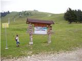 2
2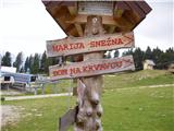 3
3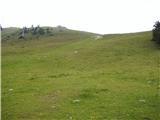 4
4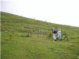 5
5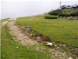 6
6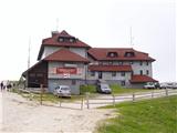 7
7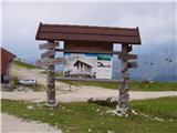 8
8 9
9 10
10 11
11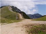 12
12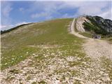 13
13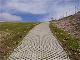 14
14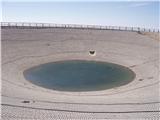 15
15 16
16
Discussion about the trip Dom na Gospincu - Veliki Zvoh
|
| Gost3. 11. 2007 |
If you want peace, then not to Krvavec. There they rumble, work, work....
|
|
|
|
| iztok1. 06. 2008 |
Yesterday we went to Krvavec and I must say it was peaceful, and you can still pick some dandelions
|
|
|
|
| reina13. 07. 2009 |
Yesterday I was on this path. Pleasant Sunday hike. Weather satisfactory. Dom na Gospincu has got a pleasant hostess Meta from Gorje. I will gladly visit her again for homemade borovničevec. Dom na Krvavcu seems to have been taken over by economists who have no idea about hospitality and cater to the young population, music blaring midday like in some disco, which can sometimes be a bit annoying. At least for us who come to the mountains for the mountains. Especially watch out, the sour milk might still be a bit frozen when served, which is real poison for the stomach.
|
|
|
To post a comment you must log in:
If you do not yet have a username, you must first
register.