Dom na Menini planini - Vivodnik
Starting point: Dom na Menini planini (1453 m)
| Latitude/Longitude: | 46,26270°N 14,81830°E |
| |
Walking time: 15 min
Difficulty: easy marked way
Elevation gain: 55 m
Elevation difference along the route: 70 m
Map: Zgornja Savinjska dolina 1 : 50.000
Recommended equipment (summer):
Recommended equipment (winter):
Views: 23.299
 | 3 people like this post |
Access to starting point:
From Kamnik or Vransko we drive to the Tuhinjska Valley. Soon after the village Zgornji Tuhinj (from Vransko a little before) at the gas station to the left (from Vransko to the right) a road towards the village Češnjice branches off. Further, we drive through the village Češnjice on the road which soon after the village becomes macadam and above the village brings us to a smaller crossroad, where we continue right in the direction of Menina planina. The road, which is mostly ascending, we follow to the mountain pasture Biba and further to Dom na Menini planini, where we park on an arranged parking lot.
From Mozirje or Gornji Grad, we drive to the Zadrečka Valley, there in the settlement Bočna we notice signs for Menina planina, which direct us to an ascending road. We then follow this road to the arranged parking lot near the mountain hut on Menina planina.
Route description:
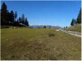
From the parking lot, we first walk to the mountain hut, from there we continue on a marked path in the direction of Vivodnik. After some 10 steps of easy walking, the path steeply ascends for a short time, then flattens and brings us to a larger grassy slope, where we encounter a signpost with the inscription "Vivodnik - krožna pot". We continue slightly left (on the right path we can return) on a relatively gentle path, which quickly brings us into a short stretch of forest. Here the path ascends again for a short time, then brings us out of the forest, where in front of us we already see the lookout tower on Vivodnik, which we reach after a few steps of further walking.
Photos:
 1
1 2
2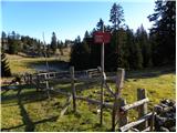 3
3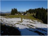 4
4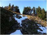 5
5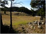 6
6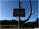 7
7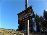 8
8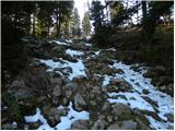 9
9 10
10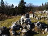 11
11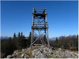 12
12 13
13
Discussion about the trip Dom na Menini planini - Vivodnik
|
| andrej jerina28. 09. 2008 |
Definitely a nice addition to the trip to Menina planina. Very nice views, and the trail is very easy. Best regards Andrej
|
|
|
|
| storžič6. 11. 2008 |
The views from the tower are really phenomenal in good weather. It's worth it
|
|
|
|
| Pohodnica5623. 01. 2011 |
Yesterday from Češnica in beautiful weather, regardless of the wind and low temperatures, although the original plan was only to Menina, I trudged to Vivodnik. At the junction where there are direction signs for Biba planina and Menina along the road, I decided to go left this time. Well marked, I can't criticize that. However, those few red pušćice had no inscriptions, so I went only by feel and "female" orientation, of course along the marked path. Towards Vivodnik it was completely. At the top unfortunately no sign which way down to the hut on Menina. If someone comes from the other direction and say first time, it's really a bit awkward. Actually, from the start of the path to the top there is only at one junction a couple of signs, of which three are useless, two can be read, but those two also turn in the wind . .
However, the day was still beautiful.
|
|
|
|
| jprim23. 01. 2011 |
Sometimes it's really interesting when you don't know where you're going.
LP!
|
|
|
|
| Pohodnica5624. 01. 2011 |
I agree, it's interesting, with emphasis on the cows. It was still a great day.
It's really interesting that no one has "trashed" me yet, even though I'm a crazy old lady
|
|
|
|
| CarpeDiem24718. 09. 2021 20:56:59 |
I'll try to attach a photo; sunset tonight, the path is really suitable for everyone
|
|
|
|
| garmont18. 09. 2021 22:03:58 |
You cannot add images to the “Commented trips” section.
|
|
|
To post a comment you must log in:
If you do not yet have a username, you must first
register.