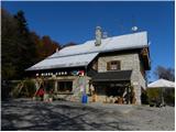
Dom na Mirni gori - Mirna gora
Starting point: Dom na Mirni gori (1000 m)
| Latitude/Longitude: | 45,62920°N 15,10270°E |
| |
Walking time: 10 min
Difficulty: easy marked way
Elevation gain: 47 m
Elevation difference along the route: 47 m
Map: Dolenjska 1:50.000
Recommended equipment (summer):
Recommended equipment (winter):
Views: 23.929
 | 5 people like this post |
Access to starting point:
A) From the highway Ljubljana - Brežice, we take the exit Ivančna Gorica, then continue driving in the direction of Črnomelj. After Črmošnjice, the road still ascends for a short time, then starts to descend more steeply. When we arrive in the settlement Vrčice, signs for Mirna gora direct us to the right onto an initially asphalted road, on which we begin to ascend gradually. Soon after the asphalt ends, the road splits into two parts. We continue on the left road (the right one is intended for those intending to ascend to Mirna gora on foot), along which we arrive after some time at the old Kočevarsko village Planina / Stockendorf (737 m). From Planina, we continue on the macadam road in the direction of Dom na Mirni gori, to which only a few kilometers of ascent remain.
B) From the highway Brežice - Ljubljana, we take the exit Novo mesto, then continue driving in the direction of Dolenjske Toplice and Podturn near Dolenjske Toplice. In Podturn, we join the main road Ivančna Gorica - Črnomelj, which we follow to the left in the direction of Črnomelj. After Črmošnjice, the road still ascends for a short time, then starts to descend more steeply. When we arrive in the settlement Vrčice, signs for Mirna gora direct us to the right onto an initially asphalted road, on which we begin to ascend gradually. Soon after the asphalt ends, the road splits into two parts. We continue on the left road (the right one is intended for those intending to ascend to Mirna gora on foot), along which we arrive after some time at the old Kočevarsko village Planina / Stockendorf (737 m). From Planina, we continue on the macadam road in the direction of Dom na Mirni gori, to which only a few kilometers of ascent remain.
C) From Bela Krajina, we first drive to Semič, then continue driving towards Črmošnjice and Soteska. Still before the road starts descending, we arrive in Vrčice, where signs for Mirna gora direct us to the left onto an initially asphalted road, on which we begin to ascend gradually. Soon after the asphalt ends, the road splits into two parts. We continue on the left road (the right one is intended for those intending to ascend to Mirna gora on foot), along which we arrive after some time at the old Kočevarsko village Planina / Stockendorf (737 m). From Planina, we continue on the macadam road in the direction of Dom na Mirni gori, to which only a few kilometers of ascent remain.
Route description:
From the parking lot, we first walk to the mountain hut, from there we continue on the left side of the tower along the marked path, which through the forest brings us to the transmitter. Near the transmitter, the path turns slightly to the left and after a few minutes of additional walking, which still proceeds through the forest, brings us to the summit of Mirna gora.
The trip can be extended to the following destinations: Mirna gora
Photos:
 1
1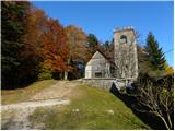 2
2 3
3 4
4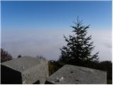 5
5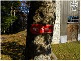 6
6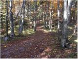 7
7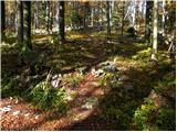 8
8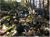 9
9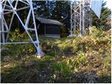 10
10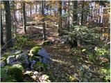 11
11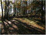 12
12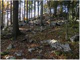 13
13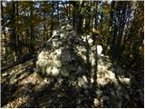 14
14 15
15
Discussion about the trip Dom na Mirni gori - Mirna gora
|
| Gost14. 01. 2008 |
nice greetings to all!!!!
You are also cordially invited to Semič, to the highest point Mirna gora which measures 1048m and has a nice view of the Semič basin and from the top you can also see Croatia!!!
Nice greetings to Semič 
|
|
|
|
| nadjau8. 04. 2008 |
To make the excursion not too short, I recommend leaving the car in your Planina and continuing for about 30 minutes along the forest educational path. Suitable, instructive and interesting for adults and children. Recommended.
Nadka, Kamnik
|
|
|
|
| MiR22. 04. 2008 |
And one more suggestion: leave the car at Vrčice (I usually do it where the asphalt ends, there's a junction and good parking), then walk nicely to Mirna gora. One way is 7 km. If it's raining, we can go along the good gravel road, but if it's dry, we can take the well-marked shortcut. This way we reach the village Planina, from there we have several options again: along the road to the hut or along the well-marked paths. One starts at the church at the beginning of the village, another is entirely along the educational forest path, or through Zmajevo dolina. Many options. The reward awaits at the friendly caretakers in the hut in the form of heavenly apple strudel and a cup of tea. Believe me, after 7 km and a few hundred meters of elevation gain, such breakfast is heavenly. Back just downhill. After such a hiked path, I always feel incredibly good when I sit in the car and drive home. Just come to the land of white birches, which is immensely beautiful and friendly.
|
|
|
|
| bobo24. 04. 2008 |
You can also go straight through the ski slope Bela (Gričice). At the top the path continues to Mirna gora. Markings? I don't remember exactly.
|
|
|
|
| tom66614. 11. 2010 |
There are also markings from the Bela ski slope to Mirna gora. Just under two hours from the parking lot one way. Nice walk.
|
|
|
|
| petr15. 12. 2010 |
I must say that in good weather you have the chance of a great view reaching all the way to Klek, especially if you climb the tower by the hut where you can see even further.
|
|
|
|
| aleš4310. 12. 2011 |
Greetings to all
From Komarna vas to Mirna gora I recommend. The path is marked. Komarna vas-Gače 1 hour, Gače-Mirna gora 1 hour. Path to Gače is muddy due to works in the forest (felling trees) further on incredible enjoyment!
|
|
|
|
| glorija1. 09. 2022 11:59:13 |
Always beautiful and enchanting Mirna gora with views..Unfortunately žiga is not at the top, the mountain hut is closed on Mondays and Tuesdays when there is someone in the hut. And nice mountain greeting!
|
|
|
To post a comment you must log in:
If you do not yet have a username, you must first
register.