Dom v Kamniški Bistrici - Kamniški Dedec (hunting trail)
Starting point: Dom v Kamniški Bistrici (601 m)
| Latitude/Longitude: | 46,32710°N 14,58930°E |
| |
Route name: hunting trail
Walking time: 2 h 45 min
Difficulty: partly demanding unmarked way
Elevation gain: 982 m
Elevation difference along the route: 1000 m
Map: Kamniške in Savinjske Alpe 1:50.000
Recommended equipment (summer):
Recommended equipment (winter): ice axe, crampons
Views: 18.831
 | 3 people like this post |
Access to starting point:
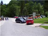
We drive to Kamnik and follow the road ahead towards the valley Kamniška Bistrica, where we park on a large parking lot near the mountain hut Dom v Kamniški Bistrici.
Route description:
From the parking lot in front of the mountain hut Dom v Kamniški Bistrici we continue on the initially still asphalted road, which after a short ascent quickly brings us into the forest. After a few minutes of walking, signposts for Kamniško sedlo point us to the right on a steep footpath, which a little higher brings us to an interesting passage below overhanging cliffs. The still steep path then brings us to the bottom station of a cargo cableway, where we step on the road. We continue left and then already after a few steps sharply right. A relatively steep forest path brings us higher to a cart track, which we follow a few tens of meters to the right, and then blazes point us to the left, where after a steep initial ascent the steepness decreases. Further in a gentle diagonal ascent we cross relatively steep slopes, after which from the left a path from the higher starting point (Jermanca) joins us.
Further, we need to pay attention, because the path will soon bring us to the spot named V Klinu, where we leave the marked path which leads towards Kamniško sedlo (to here approx. 1.5h). Here we continue right (straight Kamniško sedlo 2 hours - signpost) on an unmarked path which leads to Repov kot. We follow the mentioned path only about 100 m.
When the path gets close to the riverbed of the stream (Sedelšček) we need to pay attention to the sandy deposit on the opposite side. There we cross the riverbed and on our right we find a beaten footpath which starts rising in zig-zags on steep forest terrain. We follow the hunting footpath about 20 min. When we come to a crossing, we turn right and after a few meters we are at the hunting cottage.
Behind the hunting cottage we turn left and then straight upwards. The path winds steeply in zig-zags through the forest until it flattens. We are on the ridge of Črni vrh. The ridge path brings us below the rocky wall of Kamniški Dedec. The path winds among rocks and in a few minutes we are on the summit.
The peak, which has a summit register box, is extremely panoramic on all sides: from Planjava, Brana, Krvavec, Vel. Planina, Zeleniške špice, etc.

Photos:
 1
1 2
2 3
3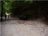 4
4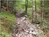 5
5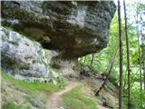 6
6 7
7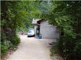 8
8 9
9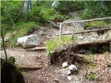 10
10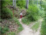 11
11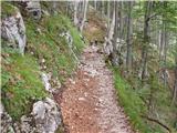 12
12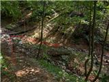 13
13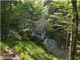 14
14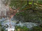 15
15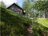 16
16 17
17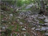 18
18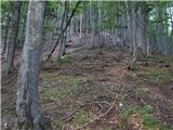 19
19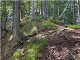 20
20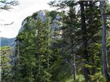 21
21
Discussion about the trip Dom v Kamniški Bistrici - Kamniški Dedec (hunting trail)
|
| EUGEN10. 09. 2009 |
Hike that I warmly recommend, been 4 times, and each time something new.
|
|
|
|
| Saten22. 10. 2009 |
Because the weather forecast was rather bad, I decided for something lower and quicker. I went up the hunting path to Kamniški Dedec. The ascent went without any issues. It hadn't started raining yet. The summit was of course without views. Those will wait for next time. On the descent, I veered too far to the right, facing the direction of descent. So I missed the trail and the roar of the torrent in the valley told me I needed to go more to the left. Without trouble, I then arrived right above the hunting hut. The main problem was the torrent, which had risen significantly in under two hours. On the ascent, I crossed it easily over the stones. Now those stones were gone. Everything was flooded. In the end, I had no choice but to find a spot where it widened a bit so it wasn't so rushing, and I waded through it. My shoes were full of water—what a joy. Good thing the car wasn't much farther. Definitely a path I'll repeat, as it holds great promise.
|
|
|
|
| tol26. 01. 2010 |
Has anyone been to this summit recently? What are the conditions from Klin to the top?
|
|
|
|
| spotonbody3. 04. 2010 |
Today I climbed to the summit for the first time, which demanded quite a bit of fatigue from me, especially because of the snow, which from the hunting hut onwards was always more and already quite soft so that it sank high over the knees in places. I will definitely repeat the trip in dry summer conditions, as Saten says, the mountain really promises a lot. Especially because of its not overly crowded nature, it allows retreat from other hikers and a trip in the pleasant 'silence' of nature. As no expert on the paths to this mountain (until today) I would like to mention that according to the description from this website I already missed the junction that crosses the torrent (I crossed it at least half an hour too early) so I was trudging up a steep forest slope without any path and probably mainly by lucky intuition arrived exactly at the hunting hut. So let me emphasize once again, after about half an hour from the cableway when you first come to a wider cart track and it forks, you must still follow at least half an hour along the path uphill towards Kamniško sedlo, only then cross the torrent, which we have on our right side in sight during that half hour. At the mentioned fork, do not go right yet, as there are also fallen trees there and it can mislead us. It did me, since there are no markers. From the hunting hut onwards because of the snow and no!! visible markers I wouldn't know where either, if I didn't have the luck again to follow the footprints of the two and only people I met right below the summit. So, thanks strangers!  But the summit really offers beautiful views in all directions! I recommend it, but still advise against it for the inexperienced in winter conditions! In summer everyone up to this beautiful panoramic summit! LP But the summit really offers beautiful views in all directions! I recommend it, but still advise against it for the inexperienced in winter conditions! In summer everyone up to this beautiful panoramic summit! LP
|
|
|
|
| tol3. 04. 2010 |
The path is a hunting path and not marked! Which is also written in the description. It might be better if it was just written that you follow the path to Kamniško sedlo to Klin, where the path forks to Kam. sedlo and to the path into Repov kot, which we follow for about 200 meters then cross the stream..
Maybe it is indeed a bit poorly written, but to Klin you follow the path to Kamniško sedlo. I assume you missed the junction at that point> http://www.hribi.net/slika.asp?pot=46841 ?
Otherwise it's good to check unknown and unmarked paths on the map beforehand.
|
|
|
|
| spotonbody4. 04. 2010 |
That's right, exactly there I went right too early. Yesterday when I returned I was reading the text under the photos, which offer an even better sense of orientation  There, where I crossed the stream, there was also a dead end and after crossing it still led for about a km a path zigzagging through the forest, so I was really already convinced that I was going right. When the path ran out, I decided either back or straight up the steep hill. The latter prevailed and panting I arrived exactly at the bench in front of the hunting hut. Now looking at the pictures in summer conditions it really looks tempting again to climb this summit once more. The logbook was unfortunately completely soaked, winter didn't spare it at all. There, where I crossed the stream, there was also a dead end and after crossing it still led for about a km a path zigzagging through the forest, so I was really already convinced that I was going right. When the path ran out, I decided either back or straight up the steep hill. The latter prevailed and panting I arrived exactly at the bench in front of the hunting hut. Now looking at the pictures in summer conditions it really looks tempting again to climb this summit once more. The logbook was unfortunately completely soaked, winter didn't spare it at all.
|
|
|
|
| grega_p16. 06. 2010 |
Well, if you have doubts about the junction, there is a log on the ground about 5m from the junction on the right side (picture http://www.hribi.net/slika.asp?pot=46843 - log at the end of the arrows), written "The path does not lead to K.sedlo". That's your path.
Today I only got to the stream because the rain had young ones :-)
Best regards to all!
|
|
|
|
| tol16. 06. 2010 |
haha grega p, the lady was walking there in winter when snow wonderfully covers the landscape and also your mentioned log. 
|
|
|
|
| grega_p16. 06. 2010 |
This note was meant for everyone, regardless of the season, as the marked log is not mentioned above in the description.
|
|
|
|
| grega_p24. 06. 2010 |
Today I finally conquered it (my first Dedec in life:-) and at 7 a.m. I was already standing on the summit - really excellent views in the sleepy morning sun. Complete silence, only on Staničev vrh two figures appeared and there were some voices from the direction of Kamniško sedlo.
The summit logbox is still completely soaked and needs replacement.
Above the hunting hut, just be careful with the path, which partly slightly gets lost among wooden forest remnants and scree.
Go up
|
|
|
|
| spotonbody24. 06. 2010 |
haha, yeah now I know that end and its branches so well, I can't get lost anymore no matter the season... and even if I do I'm stubborn, I'll crawl through anyway I have vacation today and this morning I was just thinking if I should jump again to this wonderful ded'ca, but it was decided to go to Trento and its surrounding hills for the weekend tomorrow instead. super grega that you decided for some dedec too (not only babes), the day was simply wonderful! I recommend Velika Baba in Julijcih to you too, I was there last week, absolutely fantastic view of Krnsko jezero!
|
|
|
|
| maucec4022. 08. 2010 |
Kamniški Dedec today was not occupied by hikers like most Slovenian peaks, so it was all the more suitable for today's tour. In the morning the view was wonderful, at the hunting hut just the right nook where one could enjoy a peaceful Sunday hour of rest.
|
|
|
|
| Žan5. 10. 2010 |
The summit has a new box and a new logbook.
|
|
|
|
| nevi11. 04. 2011 |
Yesterday we were at the summit. The trail is easy and clearly visible everywhere. There were quite a few visitors too. Just below the summit we found a men's watch that doesn't work anymore, but we picked it up anyway, and if the owner wants it back, let him report.
|
|
|
|
| scorpio26. 06. 2011 |
Today it was quite cloudy, so walking was excellent and despite the knee soreness it wasn't too hot for us. Views wonderful. Kamniško sedlo I could almost grab with my hand!
|
|
|
|
| gumpy26. 12. 2011 |
Today I was with my better half for the first time at the summit. The path was partially snowy, so at some places I had to search a bit for the 'best variant'. Otherwise it's a fairly strenuous ascent rewarded at the top with wonderful views - as if in a mountain amphitheater!
|
|
|
|
| mukica22. 01. 2014 |
Today wonderful day up there, beautiful views in all directions, the white peaks of the Kamnik-Savinja Alps are inviting. The path was wet so special caution was needed especially on the descent, no snow on the path to the top (only in two places). But the rumbling of avalanches from Brana and Planjava was heard. Spent a nice sunny morning at the viewpoint
|
|
|
|
| anton23. 01. 2014 |
Martina will have to go up there once more in nice weather, I was in fog and missed those beauties that you experienced........
|
|
|
|
| dprapr23. 01. 2014 |
@mukica, what about a picture so the rest of us can see some snow?
Oh right, there will be everywhere tomorrow!
|
|
|
|
| mukica23. 01. 2014 |
Here under conditions, yesterday I mixed up a bit and can't upload pictures here SNOW, there will be tomorrow
|
|
|
|
| Jany14. 08. 2017 |
Now I really don't understand anymore? So what's the difference between the path to Dedec and the "hunter's path" to Dedec. Two paths are described.
Today I was up there, and honestly, I don't know which path I took. Probably both. Before the hunter's hut I went steeply upwards. I'd like to try both paths.
|
|
|
|
| matic426. 05. 2019 |
Jany both descriptions refer to the same path. My description was up there first, why another one was made I don't know.
|
|
|
To post a comment you must log in:
If you do not yet have a username, you must first
register.