Starting point: Dösner Alm (1448 m)
| Latitude/Longitude: | 46,97980°N 13,20790°E |
| |
Walking time: 5 h 30 min
Difficulty: easy marked way
Elevation gain: 1638 m
Elevation difference along the route: 1638 m
Map:
Recommended equipment (summer):
Recommended equipment (winter): ice axe, crampons
Views: 38.617
 | 4 people like this post |
Access to starting point:
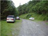
From Ljubljana through the Karawanks Tunnel to Spittal. We continue driving towards Lienz, but only to the settlement Möllbrücke. In the mentioned settlement we notice signs for Mallnitz and the alpine road to Großglockner. We follow this road to the settlement Obervellach, where signs for Mallnitz direct us to the right. Behind the village, the road starts ascending more steeply and after a few kilometers of ascent brings us to the alpine town Mallnitz. Just a little before the railway station in the mentioned place, a road branches off to the right in the direction of the mountain pasture Dösner Alm. The steep and narrow road brings us higher to a poorly marked junction, where we continue on the lower macadam road. Further we cross a pasture fence and only a little further we come to the parking lot, where we park.
Route description:
From the parking lot, we continue on the macadam road, which after a few dozen steps brings us to a path junction. We continue left on the wide cart track, which after a short ascent brings us to the mountain pasture Dösner Alm.
On the mountain pasture, we return to the road, which further barely noticeably ascends along the edge of the mountain pasture upwards. Further the road ascends a little more and brings us to the hut Konradhütte (1600m).
Only a few steps further on the left side of the road we notice a small lake, which during high water rises right to the edge of the road. At the end of the lake the road turns into a pleasant footpath, which then leads us in moderate ascent along the stream upwards. After a half-hour ascent from the hut Konradhütte we slowly pass from the forest to increasingly panoramic slopes. The path, which then becomes steeper and steeper, suddenly flattens and brings us to beautiful high-alpine pastures at the hut Dösner Hütte (1976m).
A gentle ascent follows across the pasture to a somewhat steeper section, where we can hear the roaring of the raging stream. After a further 15 minutes the steepness eases and the path brings us to a high-alpine cirque, where several streams converge. Further, over the bridge we cross the stream and then ascend one level higher on an increasingly steep path. Throughout the ascent we are accompanied by the roaring of the stream Dösenbach. When the path flattens, we cross the stream again and the path brings us to the alpine hut Arthur Von Schmid Haus, which is located by the lake Dösner See.
From the hut we continue left in the direction of Säuleck on the path, which already after a few dozen steps starts to ascend steeply. After 15 minutes of steep ascent the steepness eases and the path turns right. Further we ascend parallel to the lake, which we occasionally see to the right below us. After a further few minutes of ascent through high-alpine terrain full of granite slabs we reach a junction, where we continue straight on the easier path (left Säuleck - climbing path). The moderately steep path, which causes us orientation problems in fog, brings us after a while to the other side of the side ridge of Säuleck. Here the path turns left and ascends relatively steeply up the rocky slope (in hard snow danger of slipping). At the top of this ascent we already see the summit slope of Säuleck in front of us. A folded ascent follows along a small indistinct valley bottom to the foot of the mountain. Since the path to the summit runs over granite slabs that are not entirely stable, we take care that one of them does not overturn on us or that we roll it into the valley. After a good 20 minutes of ascending the summit slope we step onto the summit. The cross and summit register box are somewhat lower (at the top of the climbing path).

Photos:
 1
1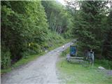 2
2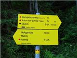 3
3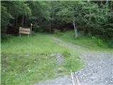 4
4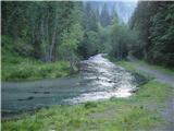 5
5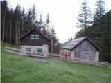 6
6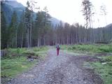 7
7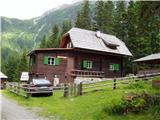 8
8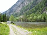 9
9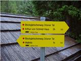 10
10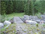 11
11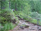 12
12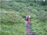 13
13 14
14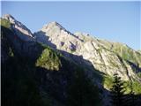 15
15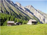 16
16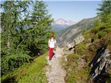 17
17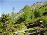 18
18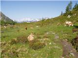 19
19 20
20 21
21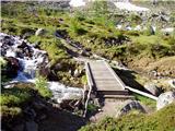 22
22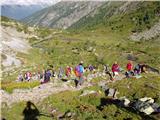 23
23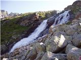 24
24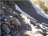 25
25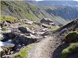 26
26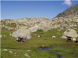 27
27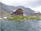 28
28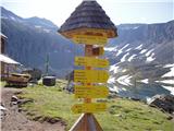 29
29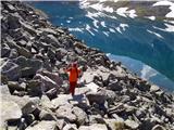 30
30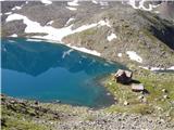 31
31 32
32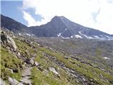 33
33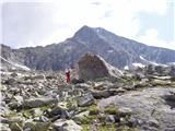 34
34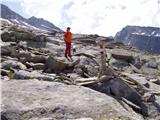 35
35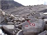 36
36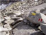 37
37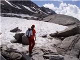 38
38 39
39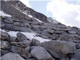 40
40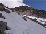 41
41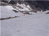 42
42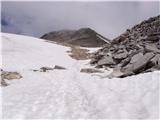 43
43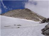 44
44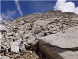 45
45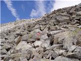 46
46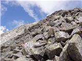 47
47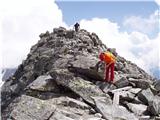 48
48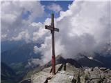 49
49
Discussion about the trip Dösner Alm - Säuleck
|
| Tadej4. 07. 2008 |
To all who haven't been to a peak over 3000m yet but want to, I recommend the ascent to Säuleck. The path is easy and not exposed anywhere.
|
|
|
|
| nekdo14. 07. 2008 |
interesting 
maybe you know some similar peak, just with a slightly more demanding path?
|
|
|
|
| Tadej6. 07. 2008 |
Slightly higher and a bit more difficult is Ankogel (3252m) with a cable car to 2600m (starting point Mallnitz), then another 3 hours on foot. Or Gr. Hafner (3076m) 5h a bit more difficult than Ankogel (starting point lake above Malta valley). None of the peaks is overly difficult to access.
|
|
|
|
| Nickster24. 07. 2008 |
Super! When is the best time to go
|
|
|
|
| zamet2. 08. 2009 |
Well today I was on Säuleck 3086m. After a clear night and good prospects, this mountain suddenly wrapped itself in fog, but right on cue when we stepped on the summit it cleared up and the view was there.
|
|
|
|
| bkovaci131. 08. 2009 |
I want to emphasize that this is one of the easier accessible three-thousanders, so even for us who have already met Abraham, the ascent to the summit was not too difficult (except that we can't make it from the valley in less than 7-8 hours, but with overnight in the upper hut it goes great). There are practically no dangers along the route (no precipitous sections, no glacier crossing needed even at the end of August). The route description mentions two more huts that are not operating! Even if you don't plan to conquer the summit, it's worth going to the Arthur Von Schmid Haus hut, located by Dösner See lake, where it's really nice. Some hikers who want to conquer the neighboring Hochalmspitze (3360 m) go in the direction of Säuleck and turn towards the neighboring mountain just below the summit. They say that on this route you don't need to cross glaciers to reach Hochalmspitze, which is quite dangerous without proper equipment. If you plan to overnight at Arthur Von Schmid Haus hut, I recommend reservation (for a room), dorm beds are usually available (price for PD member is 10 €).
|
|
|
|
| triglavski31. 08. 2009 |
Säuleck is indeed one of the easier accessible mountains, and it also has a nicely secured route (grade D,E), which is worth visiting to spice up the ascent to the summit. Of course it's possible to Hochalmspitze too, but without crossing the glacier it will hardly be possible, at least the part to the western ridge (Detmoldergrat) needs to be on the glacier.
|
|
|
|
| Jože.29. 07. 2010 |
This mountain (despite the height) has a completely easy access to the summit, that's why it got the nickname "ladies' three-thousander". With a completely moderate pace, the tour can be done in one day (from home - to home). Recommended!
|
|
|
|
| Bojan_A29. 07. 2010 |
And at that junction (where there's a yellow sign and red marking) does the via ferrata to Säuleck branch off? How difficult is it compared to the one on Cjajnik?
|
|
|
|
| Jože.29. 07. 2010 |
Trail junction. Straight ahead the usual approach, left climbing path. Yes, that picture shows the turn-off for the climbing path, but I didn't go on it because snow started a little further ahead, the summit was in fog. Regarding difficulty, I don't know.
|
|
|
|
| pima5. 08. 2010 |
Has anyone been up there recently? I'm interested in the conditions (snow), and approximately how long would the drive from Kranj to the parking lot take?
|
|
|
|
| lynx5. 08. 2010 |
No snow, conditions excellent.
|
|
|
|
| acjom5. 08. 2010 |
I'm also interested in the time to the starting point, thanks
|
|
|
|
| IgorZlodej9. 08. 2010 |
Bojan, congratulations on your first three-thousander. Nice secured path, I myself was surprised by the length, although everything looks quite close, but there the dimensions are different. It also strained my arms a bit in two places. And on the descent you can't keep your hands in your pockets everywhere, in some places it's a real maze and you progress slowly among huge rock blocks. You also have an interesting explanation about the rocks, so your descriptions are also educational. Keep it up.
|
|
|
|
| planinc9731. 05. 2011 |
I'm wondering how much driving is left from the Slovenian border to Säuleck
|
|
|
|
| atoamac31. 05. 2011 |
From the Karavanke tunnel along the motorway past Beljak and Spittal, then either a or b.:
a) to Gmünd, then into the Maltatal valley to the place Koschach and from there towards Giessenerhütte
approx. 85 km.
b) to Mallnitz approx. 110 km, from there a couple more km below Dösnerhütte.
|
|
|
|
| asvi15. 07. 2013 |
Hi, I'm interested if the path is normally accessible and there's no more snow. And if it's possible to go with a dog (no exposed parts)
thanks lp
|
|
|
|
| VanSims15. 07. 2013 |
There shouldn't be any exposed sections (I actually went via Buderusweg, which joins this path about an hour before the summit) but from the hut to the summit no cliffs are visible. The problem for a dog could be the granite blocks, which can be tricky even for humans because you don't know where one might shift under your feet. Maybe someone with experience moving a dog on such terrain knows, and it probably also depends on your dog.
|
|
|
|
| JORDAN15. 07. 2013 |
The steepest part of the path is right from the hut upwards, however it's routed through chimneys so there are no exposure issues. Regarding snow, I'm attaching pictures from Saturday's view of Hochalmspitze from the path to Hafner. I assume there's still snow on the south side of Säuleck and in the gully before reaching the ridge.
|
|
|
|
| JORDAN15. 07. 2013 |
Sorry, maybe I got tangled up. The picture shows the current conditions.
|
|
|
|
| borlepadrino11. 04. 2017 |
On Saturday 8/4 I did it alone. Snow starts a bit higher than the second wooden bridge. Didn't have touring skis. On top indescribable views. Difficulty not for grintavec.
|
|
|
|
| haridautovic1. 09. 2017 |
26.08.2017, On Saturday we were up at the summit. Path very nicely marked, only thing is you need to be used to walking on granite slabs, blocks, boulders some of which are very unstable//, along the path you simply enjoy the gurgling of the mountain stream descending from Dösner See lake-2275m, At the top wonderful views,, So we decided to stay one more day in Malnitz and visit the higher summit Ankogel,,3252m,, as the weather was favorable,,  I recommend to everyone who wants to climb over 3000+ without major problems...Just climbing gear and helmet will only be in the way,,,nowhere needed,, good luck,,, I recommend to everyone who wants to climb over 3000+ without major problems...Just climbing gear and helmet will only be in the way,,,nowhere needed,, good luck,,,
|
|
|
To post a comment you must log in:
If you do not yet have a username, you must first
register.