Dražgoše (Jelenšče) - Bela peč (Podbliška gora)
Starting point: Dražgoše (Jelenšče) (960 m)
| Latitude/Longitude: | 46,25230°N 14,18380°E |
| |
Walking time: 1 h
Difficulty: easy unmarked way
Elevation gain: 198 m
Elevation difference along the route: 200 m
Map: Škofjeloško in Cerkljansko hribovje 1:50.000
Recommended equipment (summer):
Recommended equipment (winter):
Views: 3.630
 | 3 people like this post |
Access to starting point:
A) We drive to Železniki, and then we continue driving towards Dražgoše. Through Dražgoše we follow the main road to the part of the village named Na Pečeh, where we continue slightly left onto a side road in the direction of Bičkova skala, Dražgoška gora and the hamlet of Jelenšče. Above the hamlet of Jelenšče we continue on the forest road, but only to the first crossroads, where we park at an appropriate place by the hiking signposts.
B) We drive to Kranj, and then we follow the signs for Besnica (the turn-off from the old Ljubljana - Kranj road is before the bridge over the Sava River, or after the bridge if coming from the direction of Kranj). We then drive through Spodnja and Zgornja Besnica and Njivica. A little further on we arrive at Nemilje; after the mentioned settlement, the road starts to ascend more steeply. When we arrive at Podblica, we follow the main road; above Podblica we reach the main Kropa - Dražgoše road, which we follow to the left (if the bend is too sharp, there is a turning area arranged some tens of meters to the right). We then drive past the church of St. Jedert, and soon arrive at Dražgoše, where we first reach a crossroads from which the road to Sveti Križ branches off to the left. Here we continue on the main road, then arrive at the center of Dražgoše, where in the area named Na Pečeh we turn sharply right onto a side road in the direction of Bičkova skala, Dražgoška gora and the hamlet of Jelenšče (the signs are from the opposite direction, so we can easily miss them). Above the hamlet of Jelenšče we continue on the forest road, but only to the first crossroads, where we park at an appropriate place by the hiking signposts.
C) We drive to Kropa, and then continue driving towards Dražgoše and Železniki. When we arrive at Dražgoše, in the center of Dražgoše, in the area named Na Pečeh, we turn sharply right onto a side road in the direction of Bičkova skala, Dražgoška gora and the hamlet of Jelenšče (the signs are from the opposite direction, so we can easily miss them). Above the hamlet of Jelenšče we continue on the forest road, but only to the first crossroads, where we park at an appropriate place by the hiking signposts.
Route description:
From the starting point, we continue right in the direction of Bičkova skala (left Dražgoška gora, Kališnik and Vodiška planina mountain pasture) and continue along the road, which ascends transversely to the right. After less than 10 minutes of walking, we arrive at Bičkova skala, which is located a few steps to the right of the road and from where a nice view opens up onto Dražgoše and the surrounding hills.
From Bičkova skala we continue further along the narrower asphalt road that crosses steep and occasionally panoramic slopes. Higher up, a path joins us from the right, leading along the slopes of Lajška gora (the mentioned path is marked with local signs and is poorly trodden); the road then turns slightly to the left and takes us to the Jelovica plateau.
Here, at the information board, the aforementioned marked path continues to the right, reaching Bela peč via Rigla; we, however, continue along the road, which forks a little further on. We take the right road (via the left road one can reach Kališnik), from which, after a few minutes, we branch off to the right onto a path along which we walk to the nearby Bela peč.
Description and pictures refer to the condition in 2017 (December).

Photos:
 1
1 2
2 3
3 4
4 5
5 6
6 7
7 8
8 9
9 10
10 11
11 12
12 13
13 14
14 15
15 16
16 17
17 18
18 19
19 20
20 21
21 22
22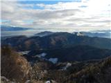 23
23 24
24
Discussion about the trip Dražgoše (Jelenšče) - Bela peč (Podbliška gora)
|
| plaNinaPirsMajcen3. 02. 2025 21:16:59 |
https://youtu.be/eRDQdkxggkw?si=ze-r37lb-tTrtn2N
Yesterday we hiked this path with friends. In the video up to 1:40 minute.
We started in Dražgoše (Jelenšče) and went past Bičkova skala to Podbliška gora. The path is not marked, but with trackability no major issues. It is definitely less visited. Back, part of us returned by road and thus ended the circular path over Podbliška gora above Bičkova skala.
We descended back to the car and went in the other direction to Dražgoška gora. This path is marked, wide and quite easy.
To the sunshine, as promised on the wooden benches (Dražgoše - here the sun is at home), hopefully next time 🌞
Best, Nina
|
|
|
|
| georgia4. 02. 2025 19:26:48 |
A bit larger and more practical loop to the mentioned two peaks:
from P at Jelenšče first to Dražgoška gora (this path is quite crowded), then further past planina Kališnik all along the forest road up - down to the main junction of forest roads already near Bela peč, hop to Bela peč and descent along the forest road (or along the path at the ridge edge) to the asphalt above Bičkova skala and descent along this road to P.
In this area I also recommend visiting nearby Britmance, which is now also described. 
|
|
|
To post a comment you must log in:
If you do not yet have a username, you must first
register.