Dražgoše (Jelenšče) - Bela peč (Podbliška gora) (via Rigli)
Starting point: Dražgoše (Jelenšče) (960 m)
| Latitude/Longitude: | 46,25230°N 14,18380°E |
| |
Route name: via Rigli
Walking time: 1 h
Difficulty: easy unmarked way
Elevation gain: 198 m
Elevation difference along the route: 200 m
Map: Škofjeloško in Cerkljansko hribovje 1:50.000
Recommended equipment (summer):
Recommended equipment (winter): ice axe, crampons
Views: 1.190
 | 1 person like this post |
Access to starting point:
A) We drive to Železniki, and then we continue driving towards Dražgoše. Through Dražgoše we follow the main road to the part of the village named Na Pečeh, where we continue slightly left onto a side road in the direction of Bičkova skala, Dražgoška gora and the hamlet Jelenšče. Above the hamlet Jelenšče we continue on the forest road, but only to the first crossroad, where we park at an appropriate place by the hiking signposts.
b) We drive to Kranj, and then follow the signs for Besnica (the turnoff from the old Ljubljana-Kranj road is before the bridge over the Sava River, or after the bridge if coming from Kranj). Further on, we drive through Spodnja Besnica and Zgornja Besnica and Njivica. A little further on, we arrive at Nemilje; after the mentioned settlement the road starts to ascend more steeply. When we arrive at Podblica, we follow the main road; above Podblica we reach the main road Kropa-Dražgoše, which we follow to the left (if the turn is too sharp, there is a turning area arranged a few tens of meters to the right). Further on, we drive past the church of St. Jedert, and then we already arrive at Dražgoše, where we first arrive at a crossroad where the road towards Sv. Križ branches off to the left. Here we continue on the main road, and then we arrive at the center of Dražgoše, where in the area named Na Pečeh we continue sharply right onto a side road in the direction of Bičkova skala, Dražgoška gora and the hamlet Jelenšče (the signs are from the opposite direction, so we can easily miss them). Above the hamlet Jelenšče we continue on the forest road, but only to the first crossroad, where we park at an appropriate place by the hiking signposts.
c) We drive to Kropa, and then continue driving towards Dražgoše and Železniki. When we arrive at Dražgoše, in the center of Dražgoše, in the area named Na Pečeh, we continue sharply right onto a side road in the direction of Bičkova skala, Dražgoška gora and the hamlet Jelenšče (the signs are from the opposite direction, so we can easily miss them). Above the hamlet Jelenšče we continue on the forest road, but only to the first crossroad, where we park at an appropriate place by the hiking signposts.
Route description:
From the starting point, we continue right in the direction of Bičkova skala (left Dražgoška gora, Kališnik and Vodiška planina) and we continue on the road which ascends diagonally towards the right. After less than 10 minutes of walking, we arrive at Bičkova skala, which is located a few steps right from the road and from where a nice view opens up on Dražgoše and surrounding hills.
From Bičkova skala we continue further on a narrower asphalt road that crosses steep and occasionally panoramic slopes. Higher up, a path joins from the right which leads on the slopes of Lajška gora (the mentioned path is marked with local signs and is poorly trodden); the road then turns a little to the left and brings us to the Jelovica plateau.
Here at the information board of the Natura 2000 area we leave it and continue right on a cart track which leads us by the edge of Jelovica, and we are still accompanied by green-white signs. After a short descent, the cart track ends, and we continue on a trodden path which continues in approximately the same direction and still runs by the edge of the plateau. There follow a few shorter ascents and descents, and occasionally from the path a nice view also opens up. The path, which runs above the slopes of Rigle, also crosses a shorter steeper slope, where especially when wet there is greater danger of slipping (the mentioned part can also be bypassed to the left on the plateau). There follows some more moderate ascent and we reach the shoulder of Jelovica, where we go right and in a few steps we arrive at Bela peč, from where a beautiful view opens up.
Description and pictures refer to the condition in December 2017 and June 2020.

Photos:
 1
1 2
2 3
3 4
4 5
5 6
6 7
7 8
8 9
9 10
10 11
11 12
12 13
13 14
14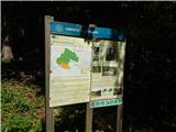 15
15 16
16 17
17 18
18 19
19 20
20 21
21 22
22 23
23 24
24 25
25 26
26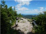 27
27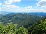 28
28 29
29
Discussion about the trip Dražgoše (Jelenšče) - Bela peč (Podbliška gora) (via Rigli)
To post a comment you must log in:
If you do not yet have a username, you must first
register.