Dvor - Polhograjska Grmada (Dvor - Grmada - Belica)
Starting point: Dvor (350 m)
| Latitude/Longitude: | 46,06590°N 14,34790°E |
| |
Route name: Dvor - Grmada - Belica
Walking time: 2 h 10 min
Difficulty: easy marked way
Elevation gain: 548 m
Elevation difference along the route: 550 m
Map: Ljubljana - okolica 1:50.000
Recommended equipment (summer):
Recommended equipment (winter):
Views: 15.812
 | 2 people like this post |
Access to starting point:
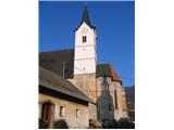
On 19.12.2007 I went to Polhograjska Grmada, namely from the village DVOR. And let's look at the entire route by car from the direction of Ljubljana, namely from the Ljubljana bypass. I actually went from the center of Ljubljana along Tržaška cesta and then turned right onto Viška cesta. On this road, I then drove over the bypass (overpass) and continued through the villages of Dobrova (2 km from the overpass above the bypass), Šujica (3 km), Razori (5 km), Hrastenice (7 km), Belica (9 km), and arrived in Dvor (10 km). It's a small village, and there are no organized parking lots visible anywhere. So I parked near the fire station, which is towards the end of the village, and walked back to the starting point. Thus, I passed by the Gothic church from 1526 and arrived at the well, where water flows continuously.
Route description:
At the well in the center of the village DVOR, I saw a tree with a hiking signpost, which was supposed to lead me to Grmada. I went uphill and at the last house, where the asphalt road ends, I realized there were no proper blazes to indicate where I should continue the path. So I went directly uphill at first, where a footpath was visible. However, after about 30 meters of walking uphill, I came to a cover, probably closing a water catchment. From there, no path was visible anymore. So I descended back to the end of the asphalt road and decided to head south along the macadam road, which leads to a newly built (currently still unfinished) house. I passed by it and again saw a blaze indicating the path uphill. From there, a steep path continued uphill, all the way to the hunting observatory. From the starting point to the hunting observatory, I walked for 35 minutes (including the time when I unnecessarily strayed from the path). From the hunting observatory onward, the path is much less steep, and this continues all the way to the hunting lodge. Between the hunting observatory and the hunting lodge, there is a crossroad of mountain paths, specifically for the directions of Polhov Gradec, Dvor, and Polhograjska Grmada. From the hunting observatory to the crossroad, I walked for 10 minutes (45 minutes in total). I continued the path and needed an additional 5 minutes to arrive at the hunting lodge, where there is another crossroad, from which you can go left towards Kmetija odprtih vrat, straight to Mala Grmada, or right at the foot of Mala Grmada to the summit of Polhograjska Grmada (avoiding the steep ascent to Mala Grmada). I decided to take the path straight ahead and went steeply uphill by the hunting lodge. From the hunting lodge to the top of Mala Grmada, I needed an additional 15 minutes (1 hour and 5 minutes in total). From there, I continued the path towards Polhograjska Grmada, descended slightly to the saddle between Mala Grmada and Polhograjska Grmada, and began the final ascent. After 10 minutes (1 hour and 15 minutes in total), I arrived at the summit of Polhograjska Grmada. The path is very poorly marked between Dvor and the hunting lodge and seems abandoned by the responsible mountaineering club, but the path is very well marked from the direction of the village Belica.
From here, wonderful views opened up towards the mountains in the north and west (Porezen, Vogel, Triglav, Golica, Stol, Storžič, Grintovec, Velika planina). A stainless steel plate at the summit greatly helped with orientation, with the directions of the sky and peaks inscribed on it. The sign was set up by PD Blagajana Polhov Gradec and PD Medvode. At the summit, there is also a new stainless steel box with a stamp, which I didn’t open, so I don’t know if the stamp and logbook are inside.
At the summit, I decided to return to the valley via the village Belica. So I descended steeply downhill and after 10 minutes arrived at a crossroad, where there are paths towards the summit, Belica, and the hunting lodge. The marking of this crossroad is critically poor, as there is only a visible signpost for the village Belica, but not for the summit or the hunting lodge. I continued the path downhill and towards the east, and after 45 minutes (55 minutes in total from the summit), I arrived in the village Belica at the main road between Ljubljana and Polhov Gradec. From there, I returned to the village Dvor along the main road, which is approximately 800 meters from Belica. After 10 minutes, I returned to the starting point.
Good luck.
My effective walking time: 2 hours and 10 minutes, from the starting point to the summit and back to the starting point
Altitude of the starting point: approx. 350 meters
Altitude of Polhograjska Grmada: 898 meters
Used literature: the book 111 izletov po slovenskih gorah and a GPS device

The trip can be extended to the following destinations: Tošč
Photos:
 1
1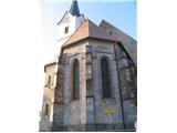 2
2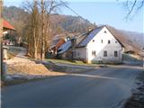 3
3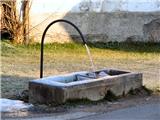 4
4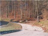 5
5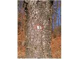 6
6 7
7 8
8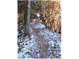 9
9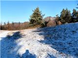 10
10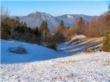 11
11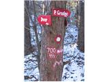 12
12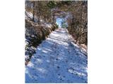 13
13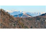 14
14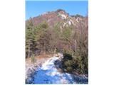 15
15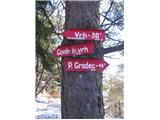 16
16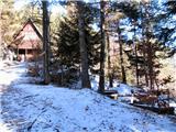 17
17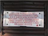 18
18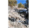 19
19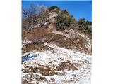 20
20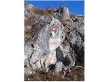 21
21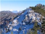 22
22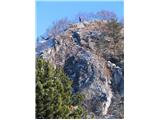 23
23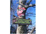 24
24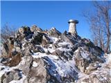 25
25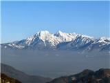 26
26 27
27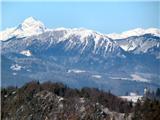 28
28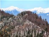 29
29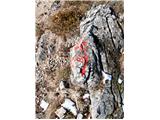 30
30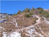 31
31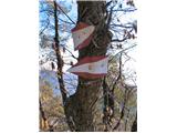 32
32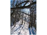 33
33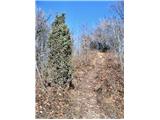 34
34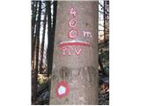 35
35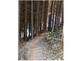 36
36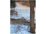 37
37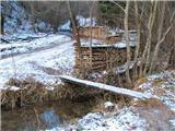 38
38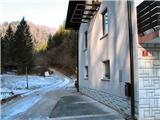 39
39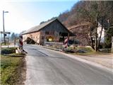 40
40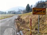 41
41 42
42 43
43
Discussion about the trip Dvor - Polhograjska Grmada (Dvor - Grmada - Belica)
|
| matic415. 03. 2009 |
I did this circular path alone a week ago. Parked left right after Dvor sign. Parking for at least 20 cars, but from around 11am already full. Water trough renovated, not as unsightly as in the photo. At summit to Belica go straight ahead and down, then the signs. For average hiker time to summit 1.5 hours. Otherwise the path is described very accurately here.
|
|
|
|
| Matt27. 04. 2009 |
On the viewpoint panel the height of Ojstrica is given as 2530 m. Correct is 2350 m.
|
|
|
|
| Lisica7. 02. 2011 |
I too, when I first went from Dvor to PG Grmada a few years ago, had problems with missing markers. I pointed this out to people who were doing something in the hut and they said everything is properly marked or that it's so trodden that there's no problem finding it. 
|
|
|
|
| Okmodko5. 09. 2011 |
I however hike from another Dvor to Grmada and the markings are better. This is Dvor above Šentvid near Ljubljana 
|
|
|
|
| Kozorog8. 09. 2011 |
Okmodko.... be so kind and write the route description if possible? If the text is too long, please send the description to ZS. Thanks! lp
|
|
|
|
| Okmodko9. 09. 2011 |
If you go from Guncelj towards Dvor, right at the beginning of the village Dvor a mountain path starts to the left. There are mountain signposts. Look at the one that says Bormes. Then follow the markings along that path, cross Dvorski hrib with a chapel on top (in the forest), then descend towards the Bormes inn. That's the first house on the left when you come out of the forest. There continue along the road, asphalt starts, then you reach the main road. Cross it, because opposite on the meadow there is a trodden path towards Slavkov dom. From Slavkov dom continue along the road, along the path to Jeterbenk. When walking along the path to Jeterbenk, near the top at the sign for Katarina turn onto that path. Along that path you reach Topol. From there I think you know the way to Grmada. The other variant is to go left on that mentioned main road. And at the first junction after three minutes at the chapel again along the left road. Along this road half an hour walk until you reach such a solitary beautiful valley without houses. At the end of this valley there is one house. From it straight up the hill and you reach Topol. With the Ljubljana surroundings map I think it's not hard to find the path. But it's quite a long walk.
|
|
|
|
| Kozorog9. 09. 2011 |
Okmodko.... Thanks! I'll try your variant because it seems very interesting and picturesque to me!
|
|
|
|
| Okmodko10. 09. 2011 |
Although... I go from Dvor because I don't have a car. The bus takes me there. If I could, I would rather drive by car already to Bormes. Because when returning, this Dvorski hrib is really superfluous, you have to cross it. Because you're already tired, then you have to do yet another hill
|
|
|
To post a comment you must log in:
If you do not yet have a username, you must first
register.