Dvorska vas - Peračica waterfall
Starting point: Dvorska vas (529 m)
| Latitude/Longitude: | 46,35840°N 14,20630°E |
| |
Walking time: 1 h 10 min
Difficulty: easy unmarked way
Elevation gain: -99 m
Elevation difference along the route: 45 m
Map: Karavanke - osrednji del 1:50.000
Recommended equipment (summer):
Recommended equipment (winter):
Views: 1.990
 | 2 people like this post |
Access to starting point:
A) From the highway Ljubljana - Jesenice take the exit Brezje, then follow the signs for Grad Podvin. In the traffic-light crossroads at Grad Podvin continue right in the direction of Begunje na Gorenjskem, then in the settlement Zgornji Otok, at a larger wooden shrine, continue slightly right on the side road in the direction of cycling signs for Dvorska vas. When we arrive in Dvorska vas, from the crossroads, where there is a chapel in the middle, continue right to the nearby sports field, where we park.
B) From the highway Jesenice - Ljubljana take the exit Radovljica, then follow the signs for Begunje na Gorenjskem. In the settlement Zapuže, at the stop sign turn right. When Zapuže ends, from the slight right bend continue slightly left, on the side road towards Dvorska vas (at the crossroads there are signs for Energijska tehnika Stroj). At the beginning of the settlement Dvorska vas the road splits, we choose the slightly right (middle) road which continues among houses. The road soon turns right, and on a relatively narrow road we drive to the chapel where we turn left. From the chapel we drive approximately 100 meters, to the sports field, where we park.
Route description:
From the starting point by the sports field ŠD Dvorska vas, we continue on the forest road which starts moderately ascending through the forest. The road quickly flattens and brings us to a crossroads on a smaller saddle.
We continue on the slightly left road (slightly right Spodnji Otok and Črnivec), which starts gradually descending. Lower, we arrive at the area named Glina, where at two smaller crossroads we continue on the right road. The path ahead still leads on the macadam road, which we temporarily leave to cross Peračica over a footbridge. When we return to the road we gradually enter Široka dolina, where the road leads us past the shrine of St. Hubert and a smaller pasture. The road, which mainly lightly descends, brings us a little further to the next crossroads, where we continue left over the bridge across Peračica (straight Črnivec).
On the other side of the bridge we also go past the green barrier, then the road starts lightly ascending, on which we walk to the marked junction, where we continue right downwards towards the Peračica waterfall.
From the spot where we leave the road we start more steeply descending, lower we cross a small bridge over Peračica, then past the logbook box and information board we descend to the pool below the Peračica waterfall.
Description and pictures refer to the condition in 2018 (January).

Along the route: Glina (475m)
Photos:
 1
1 2
2 3
3 4
4 5
5 6
6 7
7 8
8 9
9 10
10 11
11 12
12 13
13 14
14 15
15 16
16 17
17 18
18 19
19 20
20 21
21 22
22 23
23 24
24 25
25 26
26 27
27 28
28 29
29 30
30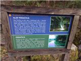 31
31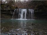 32
32
Discussion about the trip Dvorska vas - Peračica waterfall
To post a comment you must log in:
If you do not yet have a username, you must first
register.