Eisenberg an der Raab - Guard tower above Eisenberg
Starting point: Eisenberg an der Raab (344 m)
| Latitude/Longitude: | 46,88920°N 16,13591°E |
| |
Walking time: 10 min
Difficulty: easy marked way
Elevation gain: 32 m
Elevation difference along the route: 32 m
Map:
Recommended equipment (summer):
Recommended equipment (winter):
Views: 131
 | 1 person like this post |
Access to starting point:
Via the border crossing Kuzma, we drive into Austria and continue driving towards the town Jennersdorf. From the roundabout before the entrance to the expressway, we take the first exit in the direction of the settlement Sankt Martin an der Raab, in the middle of the mentioned settlement we go right, so that we continue driving on Oberdrosener Landesstraße. After 3.5 km of driving on the mentioned road, we turn left onto the Oberberg road and we start ascending. A little higher we go right (left - settlement Eisenberg) and then after approximately 50 meters we park on the parking lot at the information boards.
Route description:
From the starting point, we continue on the asphalt road, by which there are signs for the tripoint / Dreiländereck, and when after a minute of walking we arrive at the edge of the forest we go slightly right on a macadam road, on which we continue through the forest to the guard tower a few minutes away.
Description and pictures refer to the condition in February 2023.
Photos:
 1
1 2
2 3
3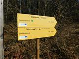 4
4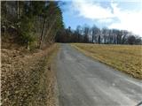 5
5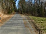 6
6 7
7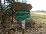 8
8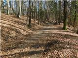 9
9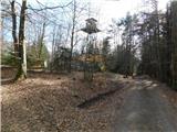 10
10 11
11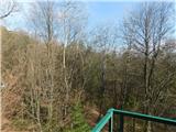 12
12
Discussion about the trip Eisenberg an der Raab - Guard tower above Eisenberg
To post a comment you must log in:
If you do not yet have a username, you must first
register.