Konec ceste na Pokljuki - Ablanca
Starting point: Konec ceste na Pokljuki (1312 m)
| Latitude/Longitude: | 46,33860°N 13,90450°E |
| |
Walking time: 2 h 20 min
Difficulty: difficult unmarked way
Elevation gain: 692 m
Elevation difference along the route: 695 m
Map: Triglav 1:25.000
Recommended equipment (summer): helmet
Recommended equipment (winter): helmet, ice axe, crampons
Views: 39.481
 | 5 people like this post |
Access to starting point:a) Leave the Gorenjska motorway at the Lesce exit, then follow the signs for Bled and Pokljuka. Continue through Gorje and past the Zatrnik ski slope to Rudno polje on Pokljuka, where there is a large paid parking lot, nearby also a military barracks and shooting range. From here continue straight along the gravel road, which shortly brings us to a junction, where we continue right (left Uskovnica). Follow this road to the former parking lot Za Ribnico, located at the end of the road (nearby are mountaineering signs for planina Konjščica).
Parking at the end of the road is now prohibited, so park already at Rudno polje, which extends the route by about 40 minutes, but it is more appropriate to choose the marked path that starts already at Rudno polje.
b) From Železniki or Podbrdo drive to Bohinjska Bistrica, then continue driving towards Bled. Shortly after the Petrol gas station, located just after Bohinjska Bistrica, continue left towards Pokljuka and Jereka. The road first ascends steeply, then gradually levels after Koriti and brings us to a junction at the bus stop, where we continue right towards Pokljuka, Koprivnik and Jereka (straight Srednja vas). Immediately after the junction we arrive at Jereka, from the junction in front of the church we continue straight towards Pokljuka (left Podjelje). After Jereka the road ascends more steeply again, higher it levels and continues along Mrzli potok. When joining the road from Bled go left and drive to Rudno polje, where there is a large paid parking lot, nearby also a military barracks and shooting range. From here continue straight along the gravel road, which shortly brings us to a junction, where we continue right (left Uskovnica). Follow this road to the former parking lot Za Ribnico, located at the end of the road (nearby are mountaineering signs for planina Konjščica).
Parking at the end of the road is now prohibited, so park already at Rudno polje, which extends the route by about 40 minutes, but it is more appropriate to choose the marked path that starts already at Rudno polje.
Traffic regime in the Pokljuka and Uskovnica area from 15.6. to 15.10.
Route description:
From the former parking lot at the end of the road, continue on a wide and initially ascending cart track towards planina Konjščica. The cart track, entering dense forest immediately, soon levels out and after a few minutes of easy walking turns into a footpath continuing along the left bank of the Ribnica stream. When the path approaches the stream closely, it turns slightly right and ascends more steeply. Higher up, the path levels and leads us from the forest to the lower edge of the vast planina Konjščica. Here the path turns slightly left, crosses a streamlet and after a few more steps brings us to the dairy hut at planina Konjščica.
From the dairy hut continue on a pleasant path that in a few minutes of gentle ascent brings us to the upper edge of the planina. Here the path enters the belt of dwarf pines and shrubs and gradually starts ascending more steeply. In the upper part of the ascent towards Jezerce, the path from Rudno polje joins from the right, we continue straight on a moderately steep path that in a few minutes of further walking brings us to Jezerce, where the path levels out and turns left (here a path to Srenjski preval branches right).
Follows easy walking to a sign indicating the central area of TNP, then the path begins to ascend moderately along a gully, initially still a streamlet. Higher up the path crosses to the right side of the gully (viewed from the direction of ascent) and then ascends across to Studorski preval, from which a nice view opens to the mountains above Bohinj.
At the pass, where we leave the markings, go left uphill on a small path. The path quickly brings us to scree terrain, where stones can be easily triggered, so caution. Follows an even steeper path leading to the ridge. Follow this path, which is quite slippery (due to sliding sand on the path) to the summit of Ablanca.
Starting point - Planina Konjščica 0:30, Planina Konjščica - Klanci 0:40, Klanci - Jezerce 0:05, Jezerce - Studorski preval 0:30, Studorski preval - Ablanca 0:20.

Photos:
 1
1 2
2 3
3 4
4 5
5 6
6 7
7 8
8 9
9 10
10 11
11 12
12 13
13 14
14 15
15 16
16 17
17 18
18 19
19 20
20 21
21 22
22 23
23 24
24 25
25 26
26 27
27 28
28 29
29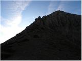 30
30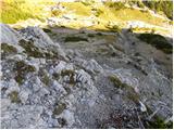 31
31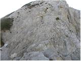 32
32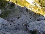 33
33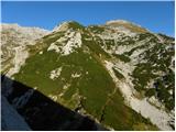 34
34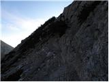 35
35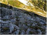 36
36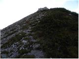 37
37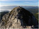 38
38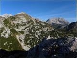 39
39
Discussion about the trip Konec ceste na Pokljuki - Ablanca
|
| gorskarozica22. 09. 2012 |
On the descent from Tosc, still a short ascent along the path to Ablanca, nice. Recommended peak, a bit of caution won't hurt! Path under your feet, you won't regret it! 
|
|
|
|
| VesnaM22. 06. 2014 |
Does anyone know how much snow is still on the path?
|
|
|
|
| nadap22. 06. 2014 |
From Jezerce plain to Studorski preval it's still quite snowy, but doable with a bit more caution. Ablanca snow-free as well as Veliki Draški vrh. Was on both on Thursday 19.06.2014 in nice weather and with magnificent views.
|
|
|
To post a comment you must log in:
If you do not yet have a username, you must first
register.