Konec ceste na Pokljuki - Begunjski vrh
Starting point: Konec ceste na Pokljuki (1312 m)
| Latitude/Longitude: | 46,33860°N 13,90450°E |
| |
Walking time: 5 h 55 min
Difficulty: difficult marked way
Elevation gain: 1149 m
Elevation difference along the route: 1350 m
Map: Triglav 1:25.000
Recommended equipment (summer): helmet
Recommended equipment (winter): helmet, ice axe, crampons
Views: 6.769
 | 1 person like this post |
Access to starting point:a) Leave the Gorenjska motorway at the Lesce exit, then follow signs for Bled and Pokljuka. Continue through Gorje and past the Zatrnik ski slope to Rudno polje on Pokljuka, where there is a large paid parking lot, nearby also a military barracks and shooting range. From here continue straight along the gravel road, which shortly brings us to a junction, where we continue right (left Uskovnica). Follow this road to the former parking lot Za Ribnico at the end of the road (nearby there are mountain signs for planina Konjščica).
Parking at the end of the road is now prohibited, so park at Rudno polje, which extends the route by about 40 minutes, but it is more suitable to choose the marked path that starts already at Rudno polje.
b) From Železniki or Podbrdo drive to Bohinjska Bistrica, then continue driving towards Bled. Shortly after the Petrol gas station, located just beyond Bohinjska Bistrica, continue left towards Pokljuka and Jereka. The road first ascends steeply, then gradually flattens after Koriti and brings us to a junction at the bus stop, where we continue right towards Pokljuka, Koprivnik and Jereka (straight Srednja vas). Immediately after the junction we arrive in Jereka, but from the junction in front of the church continue straight towards Pokljuka (left Podjelje). After Jereka the road begins to ascend more steeply again, higher it flattens and continues along the Mrzli potok stream. When we join the road from Bled, go left and drive to Rudno polje, where there is a large paid parking lot, nearby also a military barracks and shooting range. From here continue straight along the gravel road, which shortly brings us to a junction, where we continue right (left Uskovnica). Follow this road to the former parking lot Za Ribnico at the end of the road (nearby there are mountain signs for planina Konjščica).
Parking at the end of the road is now prohibited, so park at Rudno polje, which extends the route by about 40 minutes, but it is more suitable to choose the marked path that starts already at Rudno polje.
Traffic regime in the Pokljuka and Uskovnica area from 15.6. to 15.10.
Route description:
From the former parking lot at the end of the road, continue along the wide cart track initially ascending towards planina Konjščica. The cart track enters dense forest immediately, soon flattens and after a few minutes of easy walking turns into a hiking path that continues along the left bank of the Ribnica stream. When the path approaches the stream completely, it turns slightly right and ascends more steeply. Higher up, the path flattens and leads us from the forest to the lower edge of the vast planina Konjščica. Here the path turns slightly left, crosses the stream and after a few more steps brings us to the dairy hut on planina Konjščica.
From the dairy hut, continue along a pleasant path that in a few minutes of gentle ascent brings us to the upper edge of the planina. Here the path enters a belt of dwarf pines and shrubs and gradually begins to ascend more steeply. In the upper part of the ascent towards Jezerc, the path from Rudno polje joins from the right, we continue straight along the moderately steep path that in a few more minutes of walking brings us to Jezerce, where the path flattens and turns left (here a path branches right to Srenjski preval).
Follow easy walking to a sign indicating the central area of TNP, then the path begins to ascend moderately along a gully, initially still a streamlet. Higher up, the path crosses to the right side of the gully (viewed from the ascent direction) and then ascends transversely to Studorski preval, from which we get a nice view of the mountains above Bohinj.
Here a demanding path from Srenjski preval joins from the right, and from our path unmarked trails also branch to Ablanca and Veliki Draški vrh.
From the saddle, we first descend steeply for a short time, then the path turns right, and we then traverse the slopes to the left for a longer time with some shorter easy ascents and descents. From the slopes of Veliki Draški vrh we gradually arrive at the slopes of the massive Tosc, we continue with nice views past the branch to Tosc and the junction where the path from Uskovnica also joins from the left.
At all junctions, including the one where a partially abandoned path leading over planina Zgornji Tosc joins, continue straight, the path gradually brings us to steeper and even precipitous southwest slopes of Tosc mountain, where there was a landslide a few years ago, so extra caution is needed due to falling rocks. Over the precipitous section runs a fairly wide path, so there are no special difficulties in this part, when the slope becomes less steep, the path from Stara Fužina or Voje valley also joins from the left.
Continue straight along the wider marked path towards Triglav, which continues north, leading us along the western slopes of Tosc, the still gentle path brings us over some scree fields to Vodnikov dom on Velem polju, where the next junction is.
Here too continue straight towards Triglav, the path begins to ascend transversely along the slopes of Vernar, higher it also becomes technically demanding. Follow some traversing where a fixed cable assists, higher we reach a steep drop where we ascend rocky steps with the help of numerous pegs and fixed cable.
The path ahead flattens, the slope becomes less steep and near Konjsko sedlo also somewhat more grassy.
We easily descend to Konjsko sedlo, from the marked junction on the saddle we head straight on the path towards Triglavski dom na Kredarici and Staničev dom pod Triglavom (left Dom Planika pod Triglavom, right Krma valley), just a few steps further the path forks again.
Here the inscription on the rock Staničev dom directs us slightly right onto a nicely traceable but less trodden pathlet. The path ahead with some shorter ascents and descents traverses slopes to the right, crossing some gullies that may still be snow-covered in early summer. The path then crosses a belt of dwarf pines and passes onto a grassy slope across which it ascends transversely. The path then flattens and shortly crosses the path leading from Krma over Kalvarija to Kredarica.
Continue towards Staničev dom (inscription on the rock) and continue the ascent along a moderately steep path that increasingly approaches the scree fields below Rž. Along a pleasant path over Ržke pode we arrive at the mentioned scree fields, across which we begin to ascend transversely. When we reach the other side of the scree, the path turns slightly left and begins to ascend steeply through rugged rock. The steepness quickly eases and after a few more minutes of walking we join the path coming from Krma.
Continue left towards Triglav and Staničev dom along a gradually gentler path that brings us to a junction at the beginning of the ridge leading towards Dovška vrata and further to Rjavina.
Here a marked path towards Rjavina also branches right, we gradually begin to descend towards the more plateau-like area around Dom Valentina Staniča pod Triglavom.
Lower the path flattens and from the next junction continue straight towards the nearby mountain hut.
From the hut continue towards Begunjski vrh, Visoke Vrbanove špice and Cmir (sharply left Triglavski dom na Kredarici and Triglav, left Vrata valley, right Kot valley). A fairly gentle path brings us already after a few minutes of further walking to Begunjski preval, where the path to Vrbanove špice branches right, we continue straight along the path that soon forks into two parts. Here head left towards Begunjski vrh (straight to Cmir) onto the path that ascends transversely over rocky slopes. The path then turns slightly right and ascends steeply along the summit ridge of Begunjski vrh. Follow this increasingly scenic path to the summit.
Starting point - Planina Konjščica 0:30, Planina Konjščica - Klanci 0:40, Klanci - Jezerce 0:05, Jezerce - Studorski preval 0:30, Studorski preval - Planina Zgornji Tosc 0:35, Planina Zgornji Tosc - Na Zagonu 0:20, Na Zagonu - Vodnikov dom 0:20, Vodnikov dom - Konjsko sedlo 0:30, Konjsko sedlo - Pod Kalvarijo 0:30, pod Kalvarijo - Ravnica pod Ržjo 1:10, Ravnica pod Ržjo - Dom Valentina Staniča 0:15, Dom Valentina Staniča - Begunjski vrh 0:30.

Along the route: Planina Konjščica (1427m), Klanci (1678m), Jezerce (1719m), Izvir pod Studorskim prevalom (1746m),
Studorski preval (1892m), Planina Zgornji Tosc (1849m), Na Zagonu (1819m),
Vodnikov dom (1817m), Konjsko sedlo (2020m), Pod Kalvarijo (2084m), Apnenica (2337m), Ravnica pod Ržjo (2371m),
Dom Valentina Staniča (2332m), Begunjska vratca (2342m)
Photos:
 1
1 2
2 3
3 4
4 5
5 6
6 7
7 8
8 9
9 10
10 11
11 12
12 13
13 14
14 15
15 16
16 17
17 18
18 19
19 20
20 21
21 22
22 23
23 24
24 25
25 26
26 27
27 28
28 29
29 30
30 31
31 32
32 33
33 34
34 35
35 36
36 37
37 38
38 39
39 40
40 41
41 42
42 43
43 44
44 45
45 46
46 47
47 48
48 49
49 50
50 51
51 52
52 53
53 54
54 55
55 56
56 57
57 58
58 59
59 60
60 61
61 62
62 63
63 64
64 65
65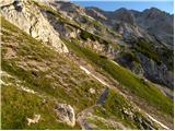 66
66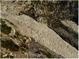 67
67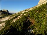 68
68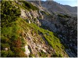 69
69 70
70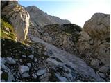 71
71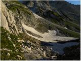 72
72 73
73 74
74 75
75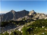 76
76 77
77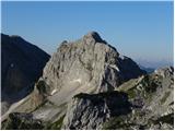 78
78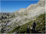 79
79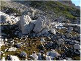 80
80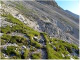 81
81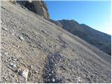 82
82 83
83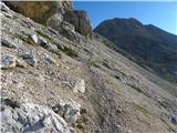 84
84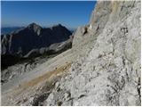 85
85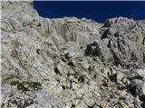 86
86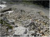 87
87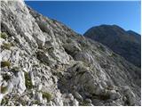 88
88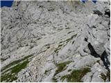 89
89 90
90 91
91 92
92 93
93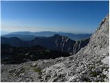 94
94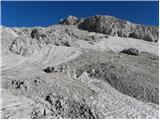 95
95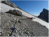 96
96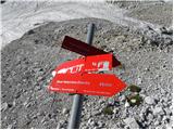 97
97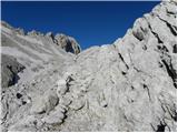 98
98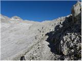 99
99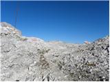 100
100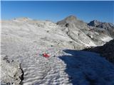 101
101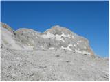 102
102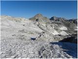 103
103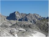 104
104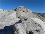 105
105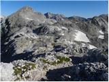 106
106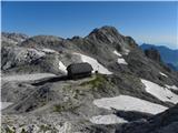 107
107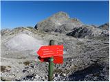 108
108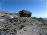 109
109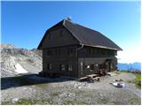 110
110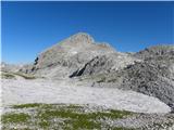 111
111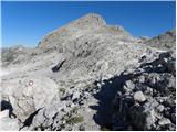 112
112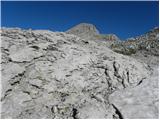 113
113 114
114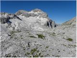 115
115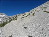 116
116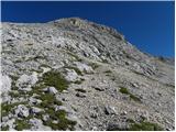 117
117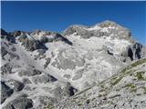 118
118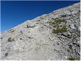 119
119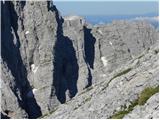 120
120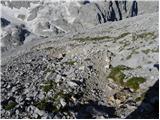 121
121 122
122 123
123 124
124 125
125
Discussion about the trip Konec ceste na Pokljuki - Begunjski vrh
To post a comment you must log in:
If you do not yet have a username, you must first
register.