Konec ceste na Pokljuki - Mali Triglav (via Planika)
Starting point: Konec ceste na Pokljuki (1312 m)
| Latitude/Longitude: | 46,33860°N 13,90450°E |
| |
Route name: via Planika
Walking time: 5 h 25 min
Difficulty: very difficult marked way
Elevation gain: 1413 m
Elevation difference along the route: 1550 m
Map: Triglav 1:25.000
Recommended equipment (summer): helmet, self belay set
Recommended equipment (winter): helmet, self belay set, ice axe, crampons
Views: 41
 | 1 person like this post |
Access to starting point:a) Leave the Gorenjska motorway at the Lesce exit, then follow signs for Bled and Pokljuka. Continue driving through Gorje and past the Zatrnik ski slope to Rudno polje on Pokljuka, where there is a large paid parking lot, nearby also a military barracks and shooting range. From here continue straight on the gravel road, which shortly brings us to a junction, continue right (left Uskovnica). Follow this road to the former parking lot Za Ribnico, located at the end of the road (nearby are mountain signs for planina Konjščica).
Parking at the end of the road is now prohibited, so park already at Rudno polje, which extends the route by about 40 minutes, but it is more suitable to choose the marked path that starts already at Rudno polje.
b) From Železniki or Podbrdo drive to Bohinjska Bistrica, then continue driving towards Bled. Shortly after the Petrol gas station, located just after Bohinjska Bistrica, continue left towards Pokljuka and Jereka. The road first ascends steeply, then after Koriti gradually flattens and brings us to a junction at the bus stop, continue right towards Pokljuka, Koprivnik and Jereka (straight Srednja vas). Immediately after the junction we arrive at Jereka, from the junction in front of the church continue straight towards Pokljuka (left Podjelje). After Jereka the road starts ascending more steeply again, higher it flattens and continues along the Mrzli potok. When we join the road from Bled go left and drive to Rudno polje, where there is a large paid parking lot, nearby also a military barracks and shooting range. From here continue straight on the gravel road, which shortly brings us to a junction, continue right (left Uskovnica). Follow this road to the former parking lot Za Ribnico, located at the end of the road (nearby are mountain signs for planina Konjščica).
Parking at the end of the road is now prohibited, so park already at Rudno polje, which extends the route by about 40 minutes, but it is more suitable to choose the marked path that starts already at Rudno polje.
Traffic regime in the Pokljuka and Uskovnica area from 15.6. to 15.10.
Route description:
From the former parking lot at the end of the road continue on the wide and initially ascending cart track towards planina Konjščica. The cart track, which immediately enters dense forest, soon flattens and after a few minutes of easy walking turns into a footpath that continues along the left bank of the Ribnica stream. When the path gets close to the mentioned stream it turns slightly right and ascends more steeply. Higher up the path flattens and takes us from the forest to the lower edge of the vast planina Konjščica. Here the path turns slightly left, crosses a stream and after a few more steps brings us to the cheese dairy on planina Konjščica.
From the cheese dairy continue on the pleasant path that in a few minutes of gentle ascent brings us to the upper edge of the planina. Here the path enters a belt of dwarf pines and shrubs and gradually starts ascending more steeply. In the upper part of the ascent towards Jezerce a path from Rudno polje joins from the right, we continue straight on the moderately steep path that in a few more minutes brings us to Jezerce, where the path flattens and turns left (here a path branches right to Srenjski preval).
Follows easy walking to a sign indicating the central area of TNP, then the path starts moderately ascending along a torrent, initially still a stream. Higher the path crosses to the right side of the torrent (viewed from the ascent direction) and then transversely ascends to Studorski preval, where a demanding path from Srenjski preval joins from the right.
From the pass, from where a nice view opens to the Bohinj side, continue straight (left Ablanca, right Veliki Draški vrh and sharply right Srenjski preval) on the path that starts descending and after a few steps turns right. Follows a short descent, then the path continues traversing, first the slopes below Veliki Draški vrh and later Tosc. When we reach the bare southern slopes of Tosc we come to a small junction where an unmarked path to Tosc branches right (the junction to Tosc is marked, but the path to it is not). Just a few steps further, a path from Uskovnica joins quite unobtrusively from the left.
Continue straight on the scenic path that starts turning more to the right, while moving to steeper slopes of Tosc. Further we reach an artificially carved rock ledge, over which runs a wide path exposed to falling rocks (caution - active rockfall!). We cross the mentioned ledge in a slight descent, then the path turns left and for a short time ascends on a somewhat narrower path. Further the path flattens and moves to less steep slopes. Just a little further we reach a marked junction where a path from Voje valley joins from the left.
Continue straight towards Vodnikov dom (slightly left Velo polje) on the gentle path, from which soon a nice view of Triglav opens. The path further returns under the slopes of Tosc and crossing scree brings us in a few minutes to Vodnikov dom on Velem polju.
From the hut continue straight towards Triglav (slightly left Koča na Doliču, right up Bohinjska vratca).
The path further moderately ascends and traverses slopes below Vernar. Soon we encounter the first fixed cable that helps "overcome" a short ledge. The path further ascends through scree and then brings us to a steep rock jump. Well secured path takes us on steep steps to the top of this jump. Follows a few meters of traversing on steep slope, then the path brings us to open areas near Konjsko sedlo, which we reach after a short descent.
From the saddle continue left towards Planika (straight Kredarica and Staničev dom, right Krma) on a relatively steep path that transversely ascends towards the west. Higher a more and more scenic path brings us to an indistinct ridge, where it turns right and temporarily flattens. Further the marked path bypasses a larger sinkhole on the right side, then starts turning left. Follows about ten minutes of ascent and the path brings us to Dom Planika pod Triglavom.
From Planika continue on the right side of the mountain hut on the marked path towards Triglav (left Triglav via Triglavska škrbina, right Kredarica). The path further first slightly descends, then gradually starts ascending. After a few minutes of easy walking, we reach a short rocky section where we transversely ascend a slightly exposed ledge. The path further turns slightly right and from rocky cliffs passes into gravel terrain, over which we ascend to the entry into the climbing section.
Already visible from afar the marking directs us into a distinct gully, through which with the aid of a fixed cable we ascend to a nice vantage point. The path further turns left, first steeply ascends, then continues over rugged rocks. Occasionally very steep and well secured at all difficult spots path brings us higher to the ridge of Mali Triglav, where a path from Kredarica also joins from the right.
Continue straight on the ridge path, which in a few dozen more steps brings us to the summit of Mali Triglav.
Start - Planina Konjščica 0:30, Planina Konjščica - Klanci 0:40, Klanci - Jezerce 0:05, Jezerce - Studorski preval 0:30, Studorski preval - Planina Zgornji Tosc 0:35, Planina Zgornji Tosc - Na Zagonu 0:20, Na Zagonu - Vodnikov dom 0:20, Vodnikov dom - Konjsko sedlo 0:30, Konjsko sedlo - Planika 1:00, Planika - Mali Triglav 0:55.

Photos:
 1
1 2
2 3
3 4
4 5
5 6
6 7
7 8
8 9
9 10
10 11
11 12
12 13
13 14
14 15
15 16
16 17
17 18
18 19
19 20
20 21
21 22
22 23
23 24
24 25
25 26
26 27
27 28
28 29
29 30
30 31
31 32
32 33
33 34
34 35
35 36
36 37
37 38
38 39
39 40
40 41
41 42
42 43
43 44
44 45
45 46
46 47
47 48
48 49
49 50
50 51
51 52
52 53
53 54
54 55
55 56
56 57
57 58
58 59
59 60
60 61
61 62
62 63
63 64
64 65
65 66
66 67
67 68
68 69
69 70
70 71
71 72
72 73
73 74
74 75
75 76
76 77
77 78
78 79
79 80
80 81
81 82
82 83
83 84
84 85
85 86
86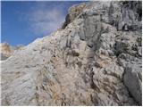 87
87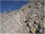 88
88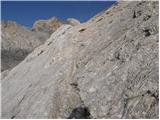 89
89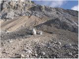 90
90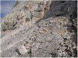 91
91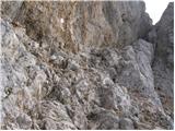 92
92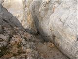 93
93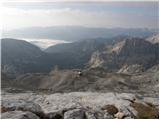 94
94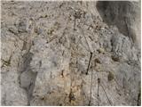 95
95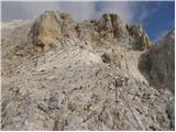 96
96 97
97 98
98 99
99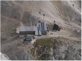 100
100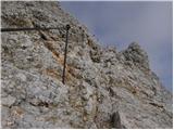 101
101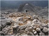 102
102 103
103 104
104 105
105
Discussion about the trip Konec ceste na Pokljuki - Mali Triglav (via Planika)
To post a comment you must log in:
If you do not yet have a username, you must first
register.