Konec ceste na Pokljuki - Tosc
Starting point: Konec ceste na Pokljuki (1312 m)
| Latitude/Longitude: | 46,33860°N 13,90450°E |
| |
Walking time: 3 h 25 min
Difficulty: easy unmarked way
Elevation gain: 963 m
Elevation difference along the route: 1015 m
Map: Triglav 1:25.000
Recommended equipment (summer):
Recommended equipment (winter): ice axe, crampons
Views: 135.499
 | 13 people like this post |
Access to starting point:a) Leave the Gorenjska motorway at the Lesce exit, then follow signs for Bled and Pokljuka. Continue through Gorje and past the Zatrnik ski slope to Rudno polje on Pokljuka, where there is a large paid parking lot; nearby there is also a barracks and shooting range. From here continue straight on the gravel road, which a bit further leads to a junction where we continue right (left Uskovnica). Follow this road to the former parking lot Za Ribnico at the end of the road (nearby mountain signs for planina Konjščica).
Parking at the end of the road is now prohibited, so park already at Rudno polje, which extends the route by about 40 minutes, but it is more appropriate to choose the marked path that starts already at Rudno polje.
b) From Železniki or Podbrdo drive to Bohinjska Bistrica, then continue driving towards Bled. Shortly after the Petrol gas station located just after Bohinjska Bistrica, continue left towards Pokljuka and Jereka. The road first ascends steeply, then after Koriti gradually flattens and leads us to a junction at the bus stop, where we continue right towards Pokljuka, Koprivnik and Jereka (straight Srednja vas). Immediately after the junction we arrive in Jereka; from the junction in front of the church, we continue straight towards Pokljuka (left Podjelje). After Jereka the road starts to ascend more steeply again, higher it flattens and continues along Mrzli potok. When we join the road from Bled go left and drive to Rudno polje, where there is a large paid parking lot; nearby there is also a barracks and shooting range. From here continue straight on the gravel road, which a bit further leads to a junction where we continue right (left Uskovnica). Follow this road to the former parking lot Za Ribnico at the end of the road (nearby mountain signs for planina Konjščica).
Parking at the end of the road is now prohibited, so park already at Rudno polje, which extends the route by about 40 minutes, but it is more appropriate to choose the marked path that starts already at Rudno polje.
Traffic regime in the Pokljuka and Uskovnica area from 15.6. to 15.10.
Route description:
From the former parking lot at the end of the road, continue along the wide and initially ascending cart track towards planina Konjščica. The track enters dense forest immediately, levels out quickly, and after a few minutes of easy walking turns into a footpath continuing along the left bank of the Ribnica stream. When the path approaches the stream, it turns slightly right and ascends more steeply. Higher up, it levels and leads from the forest to the lower edge of the vast planina Konjščica. Here the path turns slightly left, crosses a brook and after a few more steps reaches the dairy at planina Konjščica.
From the dairy, follow the pleasant path which brings us in a few minutes of gentle ascent to the upper edge of the planina. Here the path enters a belt of dwarf pines and shrubs and gradually starts ascending more steeply. In the upper part of the ascent to Jezerca, the path from Rudno polje joins from the right; we continue straight on the moderately steep path which in a few more minutes leads to Jezerca where it levels and turns left (a path branches right to Srenjski preval here).
Follows easy walking to a sign indicating the central TNP area, then the path begins to ascend moderately along a gully, initially a streamlet. Higher, the path crosses to the right side of the gully (as viewed in ascent direction) and then ascends transversely to Studorski preval from which a nice view opens to the mountains above Bohinj.
Here a demanding path from Srenjski preval joins from the right, and from our path unmarked tracks also branch to Ablanca and Veliki Draški vrh.
From the saddle first descend steeply for a short while, then the path turns to the right direction, and we then traverse the slopes to the left for longer with some shorter easy ascents and descents. From the slopes of Veliki Draški vrh we gradually arrive at the slopes of massive Tosc, we with nice views continue to the marked junction for Tosc, the path ahead is unmarked.
Continue on the unmarked but well traceable path which starts ascending ever more steeply across the grassy southeast slopes of Tosc. The increasingly steep path slowly turns somewhat right, then sharply left and almost levels out. Follows traversing a short steep slope, then the path leads to less steep slopes where it begins to fade gradually. The less visible little path then turns slightly right and starts ascending somewhat more steeply. After a few minutes of ascent we step onto indistinct Mali Tosc from which a view of Tosc opens. Follows a short descent and the path past a larger sinkhole which we bypass on the right brings us to the summit base of Tosc. The path ahead ascends moderately across pleasant grassy slope and after a few more minutes of walking leads to the summit of Tosc.
Orientation in fog is fairly difficult.
Starting point - Planina Konjščica 0:30, Planina Konjščica - Klanci 0:40, Klanci - Jezerce 0:05, Jezerce - Studorski preval 0:30, Studorski preval - Planina Zgornji Tosc 0:35, Planina Zgornji Tosc - Mali Tosc 0:50, Mali Tosc - Tosc 0:15.

Photos:
 1
1 2
2 3
3 4
4 5
5 6
6 7
7 8
8 9
9 10
10 11
11 12
12 13
13 14
14 15
15 16
16 17
17 18
18 19
19 20
20 21
21 22
22 23
23 24
24 25
25 26
26 27
27 28
28 29
29 30
30 31
31 32
32 33
33 34
34 35
35 36
36 37
37 38
38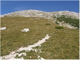 39
39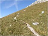 40
40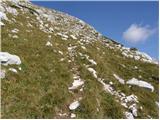 41
41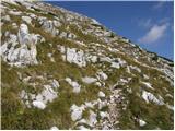 42
42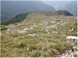 43
43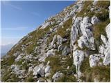 44
44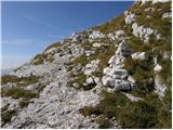 45
45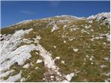 46
46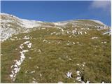 47
47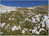 48
48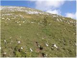 49
49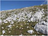 50
50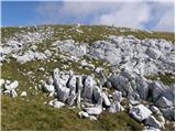 51
51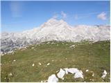 52
52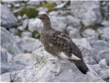 53
53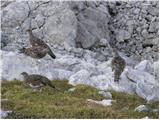 54
54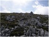 55
55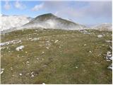 56
56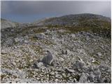 57
57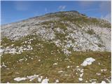 58
58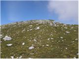 59
59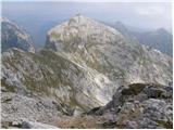 60
60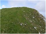 61
61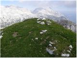 62
62
Discussion about the trip Konec ceste na Pokljuki - Tosc
Show older messages
|
| Gost5. 11. 2006 |
Tosc is a beautiful panoramic mountain with a grassy summit. But it has one flaw, the summit is full of sheep "droppings". The trail is panoramic and not demanding and in the last part despite no path it's not hard to find the summit.
|
|
|
|
| Gost11. 07. 2007 |
Soon I plan to go to Tosc (two-day tour)
|
|
|
|
| Gost11. 07. 2007 |
If you plan a two-day trip, it is best to overnight at Vodnikov dom and choose a room with a view of Triglav.
|
|
|
|
| Gost13. 07. 2007 |
Thanks ! !
|
|
|
|
| Gost10. 09. 2007 |
Yesterday I was on Tosc and really enjoyed the wonderful view of Triglav and surrounding hills. I will definitely go to Tosc again. Next time maybe from Uskovnica.
|
|
|
|
| roger15. 10. 2007 |
Yesterday I did the mentioned path with two colleagues and it was very fine for us. At first we walked in fog and there were no views but gradually the fog cleared and at the foot of the Studorski preval we were already basking in the sun. The path to Studorski preval was very interesting with a wonderful view of Mali Draški vrh. At the top of the pass it was very windy and the jacket was very useful. Then half an hour of walking along the southern foot of Tosc then lunch after which a steep ascent to the top. On the summit plateau snow awaited us which lingers in shady areas but there is just a sample of snow. At the top a wonderful view of our Triglav and surrounding mountains. lp
|
|
|
|
| Gost7. 11. 2007 |
On Sunday I plan to go to Tosc, interested in how much snow there is and where it starts? Of course all depends on weather!
LP
|
|
|
|
| Gost8. 11. 2007 |
On Saturday we were at Viševnik. On the way to it past the cable car there is almost no snow. We returned via Jezerca and Konjščica, where there was quite some snow in the first part of the path (descent from Srenjski preval). Since it was very warm, we just enjoyed the descent, if the snow had been hard, an ice axe would have been quite welcome. I don't know the paths to Tosc, but the conditions there are probably similar.
|
|
|
|
| Gost13. 11. 2007 |
Today I was at TOSC - snow only as a sample, really nice tour - I recommend gaiters for dry feet and of course caution.
|
|
|
|
| Edina9. 09. 2009 |
A guest complaining about poop inspired me to write. My advice: stay home where sheep can't reach and don't forget you're intruding into their world. Otherwise I've been to Tosc on this path several times, yesterday's view was unprecedented. Wonderful.
|
|
|
|
| katjuša29. 09. 2009 |
Oh Edina, check the date, it was 5.11.2006
Glad you had a nice view, we also like to go up there.
|
|
|
|
| velkavrh2. 08. 2010 |
Today conquered such a beautiful mountain, yet so solitary. If heading straight up first, the path start can easily be missed, though marked on a rock by the trail. It passes by unnoticed. The path is very steep at the start. After about three-quarters hour a green oasis opens up. In a hollow there was still snow occupied by sheep. It was an exceptionally fine sunny day, cloudless. At the top a superb panoramic view unfolds all around. Triglav like on the palm of the hand. The strenuous ascent thus rewarded.
|
|
|
|
| damijanp17. 10. 2010 |
Probably the last "snow-free" day of this year we used to visit Tosc. Unfortunately we weren't graced with sun, but the trip was still very nice - peace and autumn at every step. We also saw silver firs slowly donning their winter colors. At the top an exceptional view ... on the daughter and wife  , the rest was in fog. , the rest was in fog.
Pictures are at:
Tosc
|
|
|
|
| igor.mateja23. 10. 2010 |
Today we were at the summit, where winter conditions already prevail. There was snow up to your ass on the snow patches. For company, we had a group of chamois and one stoat.
|
|
|
|
| mihovca131. 01. 2011 |
On Saturday 29.01.2011 we headed to Tosc. Start at 6.30 from Rudno polje via Studorski preval and along the southern slope to the summit. From Jezerca to the pass sinking to the knees, later frozen snow. Southern slope very dangerous for slipping. Bad luck with weather - fog enveloped us towards the summit, hard to find the top and later descent (visibility 10-15 m). Start - summit (4.5 h), summit - return (2.5 h).
|
|
|
|
| rogoza4. 06. 2011 |
On Thursday 02.06.11 I was up with the group. Despite not the best weather, fog.. it was super. Sheep are already up
|
|
|
|
| sabina19674. 06. 2011 |
Rogoza, where are some pics...
|
|
|
|
| Lunatic5. 07. 2011 |
2.7.11 at 5:00 at the last parking lot car shows 2°C at 7:30 on summit, blast of strong northerly approx. -2°C, on descent 50 sheep attack sniffing out some remains... Anyway back at car at 10:15, practically whole day still ahead, conditions generally OK.
|
|
|
|
| Micky16. 07. 2011 |
I'm going to Tosc tomorrow.
|
|
|
|
| Micky17. 07. 2011 |
Well, we're home. Nice view of Tosc. Magnificent view of Planika and Kredarica. Not too hot a day, on the way back it almost rained - Hike successful in all respects.
|
|
|
|
| bostjanp8. 11. 2011 |
Thanks Misolovka for the pictorial info for Tosc. A nice weekend is coming and good provision for Tosc. Let's go.
|
|
|
|
| kitina12. 11. 2011 |
Today I was at Tosc, weather was great except for the wind. Lp.
|
|
|
|
| pelican12. 11. 2011 |
How much snow is there on the path?
|
|
|
|
| mary15. 11. 2011 |
I have one question... End of the week I plan to climb to Tosc. For the trail start I chose Rudno polje, return via Pl. Konjšcica to the end of the road on Pokljuka. I'm interested how long the road walk from "end of road on Pokljuka" back to Rudno polje would take, where I'd have the car at the barracks? Namely, the day is short, so every time estimate helps Thanks, Lp
|
|
|
|
| nevica31. 03. 2012 |
Perfect day conquering Tosc and V. Draški vrh. The path from Studorski preval to Tosc summit is dry, some snow still from Jezerca to the pass. Divine views.
|
|
|
|
| anamarija22. 07. 2012 |
Where for a 3-day tour? Day 1: end of road on Pokljuka - Vodnikov dom; Day 2: Tosc - to some hut where I overnight and third day another peak then down to the valley for the car at the end of road on Pokljuka. Any idea?
|
|
|
|
| mukica22. 07. 2012 |
one of the options..I suggest first to Tosc, then to Vodnikova koča for sleeping..second day then through Velska dolina to Dolič, to Kanjavec sleeping Dolič or Prehodavci...return Dolič-Planika-Pokljuka...depending on fitness,weather..number of tour participants..best map and some book with tour descriptions in handNice and safe hiking I wish
|
|
|
|
| ciklama26. 08. 2012 |
Yesterday we caught, hope not the last, nice summer day and used it for the ascent to Tosc. Great tour, especially from there onwards where the trail leaves the Triglav main road. The summit had quite a few visitors yesterday. Already a little before the top a beautiful view opens onto Očak and its surroundings (Kredarica, Planika etc.). Otherwise, visibility was excellent yesterday anyway and the entire surrounding panorama was visible. In short, a day for the chosen...
|
|
|
|
| KUME26. 12. 2012 |
I also caught a beautiful day and must say that the view from the top is beautiful. It was possible to see the Gulf of Trieste as well ....
|
|
|
|
| Matej_K.27. 12. 2012 |
What are the conditions like on the path?
|
|
|
|
| AnzeKozjek30. 07. 2013 |
Hello! Could someone help me choose a nice interesting Saturday morning tour. I'm choosing between Veliki Draški vrh, Mali Draški vrh (via Viševnik) and Tosc. Which one would you recommend? Thanks for the help and have a nice hiking day!
|
|
|
|
| serznoz30. 07. 2013 |
In my experience, you can hike all the mentioned ones in one day, including Ablanca.
Good luck.
|
|
|
|
| tinky30. 07. 2013 |
see current conditions, Julijske alpe, p. 16, Tosc and Ablanca. tinky.
|
|
|
|
| Bandzo27. 10. 2013 |
Yesterday we headed to Tosc despite the forecast of worse weather for the Julians on Friday. We simply knew it would be a nice day and set off. We were greeted by such a beautiful day we hadn't expected at all. Cloudless, superb views and excellent rest on Tosc, where we enjoyed the embrace of the mountains for almost two hours Tosc is wonderful!
|
|
|
|
| velkavrh6. 03. 2014 |
I'm curious if anyone has hiked to Tosc in the last days and if it's trodden.
|
|
|
|
| ljubitelj gora6. 03. 2014 |
I'd go through the most avalanche-prone terrain
|
|
|
|
| 5376351. 06. 2014 |
Hello! Has anyone been to Tosc (from Pokljuka) in the last few days? What are the conditions like, is the path already passable without winter gear?
|
|
|
|
| laik5. 06. 2014 |
I'm curious about the conditions from Runega polja to the top of Tosc.... many thanks for the information
|
|
|
|
| Painstouch22. 08. 2014 |
FOR INFORMATION: "When we reach the unmarked southern slopes of Tosc we will come to a small junction where an unmarked path to Tosc branches right (the junction is marked)." --> This part is very poorly written and contributed to our wrong decision on the hike, when we reached Vodnikova koča instead of Tošč. We found out that the path to Tošč branches at KLOPCE on this grassy slope and the direction is written on a stone (very poorly) with an arrow pointing upwards along the slope.
I wish everyone better visibility of this stone and summit success.
|
|
|
|
| Daaam22. 08. 2014 |
Painstouch... Let these descriptions here be just for information and not the only source. If you had used a good map on site, I doubt you would have gone all the way to Vodnikova koča. ..if I can be a bit annoying, then I'll say that during the hike you also need to look around a bit and think in advance where the path might go (if you don't know the area) Even if you looked at the photos carefully, you would probably have turned back at latest at the fallen trees. Best regards..
|
|
|
|
| sirt122. 08. 2014 |
On sl.38 the junction is clearly visible
|
|
|
|
| aditaker30. 08. 2014 |
I would ask, if I have fear of heights and cliffs and get dizzy, is Tosc suitable for me or rather not? Meaning, is there an easy marked path up there on which I wouldn't have trouble conquering its summit?
|
|
|
|
| gorolazka30. 08. 2014 |
You wouldn't have any problems. The path is easy and completely suitable for those prone to dizziness.
|
|
|
|
| Grenaleva19. 09. 2014 |
Regarding the junction, I can add that now next to the stone there is a wooden bench from which you can admire the view of a small part of Lake Bohinj, if the weather permits. Yesterday there was fog above 1900 m, but the path to the summit is well marked with cairns, except perhaps a couple of minutes below the summit, on the descent the fog thickened a lot and at times the distance between two cairns was not visible. You really need to remember the path well, because just below the summit it can be quite hard to find the right path back in the fog.
|
|
|
|
| katja874. 11. 2014 |
On Sunday we did a wonderful circular tour: End of the road on Pokljuka - Jezerce - Studorski preval - Vodnikov dom - Bohinjska vratca - Vernar - Bohinjska vratca - Tosc (off-path through the NW wall) - Studorski preval - Jezerce - Pokljuka. For the whole tour we needed 11 hours, with longer stops at the summits.
The entire path was dry, except the part from Jezerce to Studorski preval and individual ledges in the NW wall of Tosc.
The path to Tosc through the NW wall is a real pleasure, as it requires quite a bit of orientation and knowledge in finding passages and ledges. We reached climbing grade II in the rock. But the feeling after climbing the wall is indescribable
More photos and tour description are posted on the website of Planinsko društvo Matica Murska Sobota: http://www.pdmaticams-drustvo.si/
|
|
|
|
| jocjoc5. 11. 2014 |
Prekmurci, you are excellent and have a super photographer. When I look at your photos, the path is completely clear and easy. I wish you many more mountain and photographic adventures.
|
|
|
|
| EvaSchmitt19. 11. 2014 |
Has anyone been to Tosc today or in the last few days? What's the path like? Is it passable?
|
|
|
|
| velkavrh2. 11. 2015 |
Zgembo, beautiful, I'll check out the other peaks in the afternoon.
|
|
|
|
| Zgembo2. 11. 2015 |
There are a few peaks nearby, I went via Veliki Draški vrh and Ablanca on the way.
|
|
|
|
| Irina8. 02. 2016 |
@smatjaž,
unfortunately it doesn't work on Mac.
|
|
|
|
| smatjaz8. 02. 2016 |
Too bad... do you have PowerPoint program?
|
|
|
|
| Irina10. 02. 2016 |
@smatjaz,
no, I don't have the pp program either. I'll solve the rest by opening the page on the library computer and viewing your contribution there. Thanks for stopping by and trying to help. Safe steps and good luck!
|
|
|
|
| kabe15. 05. 2016 |
Hi!
I'm interested in the snow cover towards Tosc and further towards Velo polje. Especially in the Studorski preval area. I know that the slopes above are very avalanche-prone.
Thanks for the info
|
|
|
|
| cotro430. 12. 2016 |
Well, really about a week ago, conditions were dry and no problems, below Studorski frozen snow that doesn't cause issues ...
|
|
|
|
| Pelca10. 05. 2017 |
I have a question - I'd go to Tosc, then from Tosc to Vodnikova koča. Do I have to go back from the summit to the junction or can I take a "shortcut" somewhere from the summit to the hut?
|
|
|
|
| B210. 05. 2017 |
The best is the one back "to the bench" and to Vodnik...
|
|
|
|
| Gost10. 05. 2017 |
I went in the opposite direction. First to Vodnikova koča, then to Bohinjska vratca, en route left to Vernar, then along the north side to the summit. But you need to master first-degree climbing. I wouldn't descend there though.
|
|
|
|
| mmcajna27. 07. 2018 |
I'M GOING TO TOSC NEXT WEEK TOO
|
|
|
|
| golica27. 06. 2019 |
I have one question, maybe very simple (for someone
), which path would be the best match for this one to Tosc: Špik steep ledges, Veliki vrh, Viševnik, Stol? I know it crosses slopes, is it exposed anywhere/at all?
thanks
|
|
|
|
| Grenaleva27. 06. 2019 |
None of these... it is nicely laid out and varied, after the slope comes a steep section in the last 45 minutes, towards the top it looks like you are on the moon - but no precipices, the reward is a divine view from Triglav to the sea
|
|
|
|
| Enka4. 10. 2019 |
Beautiful path, always nicely traceable. Some difficulties in more foggy conditions between Mali Tosc and the foot of Tosc, because all those "space" rocks are quite similar to the cairns and therefore harder to spot, the path gets lost. But no major problems, even if conditions are not ideal. Views from the summit magnificent.
|
|
|
|
| IgorV13. 08. 2021 16:47:41 |
Great trail, just the right difficulty for a day hike. I recommend extending the trail to Vodnikova koča before the summit ascent and climbing to Tosc peak on the way back. Great views from the top, and no crowds up there. Recommended.
|
|
|
|
| baloncek0510. 07. 2022 18:20:53 |
Tosc- circular trail we would do from Rudno polje. What do you recommend, so that it's also for teenagers?
|
|
|
|
| ŠpRo2930. 09. 2022 09:23:55 |
Hello, does anyone know if Vodnikova koča is still open and what the conditions on Tosc are like. Has it been raining or snowing these days? Thanks.
|
|
|
|
| Janez Seliškar30. 09. 2022 10:57:16 |
Just call Vodnikov dom and ask them!
|
|
|
|
| Jusk2. 10. 2022 20:51:43 |
For @ŠpRo29.. It should be open until the end of October according to this information https://www.pzs.si/koce.php?pid=196 hope this info is more useful to you than Janez's wisecracking. Regarding snow on the path, I don't know. Best regards.
|
|
|
|
| bos2. 10. 2022 20:53:41 |
In my opinion until 9.10.2022, based on the possibility of booking accommodation.
|
|
|
|
| ŠpRo293. 10. 2022 13:02:35 |
Thanks everyone, I called them, the gentleman said until 7.10. Maybe even longer, given the wonderful weather . When I asked about the weather, he said (Friday) it's been raining for 4 days straight and he doesn't even look at the forecast anymore because it's totally off lately, which I completely agree with, but this current one, let's hope it holds
|
|
|
|
| VitoK2. 11. 2022 13:18:54 |
Just saying, on the stone by the bench, there's no longer the inscription, they painted it over with gray paint...
|
|
|
|
| saqo29. 09. 2025 08:36:30 |
Hi,
does anyone know if that rock with the painted mark for the ascent to Tosc is still there down on the path?
Is there another path from Tosc down to get directly to Vodnikov dom?(so you don't go down the same path)
thanks
|
|
|
|
| Darxta29. 09. 2025 13:03:16 |
Hello sago,
The inscription on the stone has faded, but the path or junction is clearly visible and the only one in this section of the trail.
There are no other easy paths down from Tosc.
|
|
|
|
| jax29. 09. 2025 13:06:14 |
You can go straight ahead too, but it's neither quite easy nor quite simple to find. If you're interested, I definitely recommend trying to find the passage on the ascent.
|
|
|
To post a comment you must log in:
If you do not yet have a username, you must first
register.