Konec ceste na Pokljuki - Vernar
Starting point: Konec ceste na Pokljuki (1312 m)
| Latitude/Longitude: | 46,33860°N 13,90450°E |
| |
Walking time: 4 h 15 min
Difficulty: very difficult pathless terrain
Elevation gain: 913 m
Elevation difference along the route: 1020 m
Map: Triglav 1:25.000
Recommended equipment (summer): helmet
Recommended equipment (winter): helmet, ice axe, crampons
Views: 24.404
 | 6 people like this post |
Access to starting point:a) Leave the Gorenjska motorway at the Lesce exit, then follow the signs for Bled and Pokljuka. Continue driving through Gorje and past the Zatrnik ski slope to Rudno polje on Pokljuka, where there is a large paid parking lot, nearby also a military barracks and shooting range. From here continue straight on the gravel road, which shortly brings us to a junction, where we continue right (left Uskovnica). Follow this road to the former Za Ribnico parking lot, located at the end of the road (nearby are mountaineering signs for planina Konjščica).
Parking at the end of the road is now prohibited, so park at Rudno polje, which extends the route by about 40 minutes, but it is more appropriate to choose the marked path that starts already at Rudno polje.
b) From Železniki or Podbrdo drive to Bohinjska Bistrica, then continue driving towards Bled. Shortly after the Petrol gas station, located just behind Bohinjska Bistrica, continue left towards Pokljuka and Jereka. The road first climbs steeply, then after Koriti gradually flattens and brings us to a junction at the bus stop, where we continue right towards Pokljuka, Koprivnik and Jereka (straight Srednja vas). Immediately after the junction we arrive in Jereka, but from the junction in front of the church continue straight towards Pokljuka (left Podjelje). After Jereka the road starts climbing steeply again, higher up it flattens and continues along the Mrzli potok stream. When we join the road from Bled, go left and drive to Rudno polje, where there is a large paid parking lot, nearby also a military barracks and shooting range. From here continue straight on the gravel road, which shortly brings us to a junction, where we continue right (left Uskovnica). Follow this road to the former Za Ribnico parking lot, located at the end of the road (nearby are mountaineering signs for planina Konjščica).
Parking at the end of the road is now prohibited, so park at Rudno polje, which extends the route by about 40 minutes, but it is more appropriate to choose the marked path that starts already at Rudno polje.
Traffic regime in the Pokljuka and Uskovnica area from 15.6. to 15.10.
Route description:
From the former parking lot at the end of the road, continue on the wide initially ascending cart track towards planina Konjščica. The cart track, which immediately enters dense forest, soon flattens and after a few minutes of easy walking turns into a hiking path that continues along the left bank of the Ribnica stream. When the path gets close to the stream, it turns slightly right and ascends more steeply. Higher up, the path flattens and takes us from the forest to the lower edge of the vast planina Konjščica. Here the path turns slightly left, crosses the stream and after a few more steps brings us to the cheese dairy on planina Konjščica.
From the cheese dairy continue on the pleasant path that in a few minutes of gentle ascent brings us to the upper edge of the planina. Here the path enters the belt of dwarf pines and shrubs and gradually starts to ascend more steeply. In the upper part of the ascent towards Jezerca, the path from Rudno polje joins from the right, we continue straight on the moderately steep path that in a few more minutes brings us to Jezerca, where the path flattens and turns left (here the path to Srenjski preval branches right).
Follows easy walking to the sign indicating the central area of TNP, then the path begins to ascend moderately along the torrent, initially still a streamlet. Higher up the path crosses to the right side of the torrent (viewed from the ascent direction) and then ascends transversely to Studorski preval, from which we have a nice view of the mountains above Bohinj.
Here a demanding path from Srenjski preval joins from the right, and from our path unmarked trails also branch off to Ablanca and Veliki Draški vrh.
From the saddle we first descend steeply for a short time, then the path turns right, and we then cross the slopes to the left for a longer time with some shorter easy ascents and descents. From the slopes of Veliki Draški vrh we gradually arrive at the slopes of the massive Tosc, we continue with nice views past the branch to Tosc and the junction where the path from Uskovnica also joins from the left.
At all junctions, including the one where the partly abandoned path over planina Zgornji Tosc joins, continue straight, the path gradually brings us to the steeper and also precipitous southwest slopes of Tosc mountain, where there was a landslide a few years ago, so extra caution is needed due to falling rocks. Across the precipitous part runs a quite wide path, so there are no special difficulties in this section, when the slope becomes less steep, the path from Stara Fužina or Voje valley also joins from the left.
Continue straight on the wider marked path towards Triglav, which continues north, leading us along the western slopes of Tosc, the still gentle path takes us over some scree to Vodnikov dom on Velem polju.
At Vodnikov dom turn right towards Bohinjska vratca and Krma (straight Triglav), where we first ascend past the botanical garden, then start steeply ascending the steep, mostly grassy slopes between Vernar on the left and Tosc on the right. Higher we reach an indistinct valley, along which in a few minutes we ascend to Bohinjska vratca, from where we have a nice view towards Krma.
From Bohinjska vratca continue left on an unmarked path that leads up the grassy slope. The grassy slope becomes steeper and steeper and is especially dangerous for slipping when wet. Follow the steep path, which runs slightly left of the ridge all the way to the grassy forepeak at 2183 m.
From the forepeak continue along the ridge and first descend steeply a few meters on the rocky slope. Continue along the ridge, which becomes quite narrow and exposed. Walk mostly on the left side of the ridge, the direction is also indicated by some cairns. Followed by a few very short scrambling sections (I-II grade) and we are at the summit of Vernar.
Starting point - Planina Konjščica 0:30, Planina Konjščica - Klanci 0:40, Klanci - Jezerce 0:05, Jezerce - Studorski preval 0:30, Studorski preval - Planina Zgornji Tosc 0:35, Planina Zgornji Tosc - Na Zagonu 0:20, Na Zagonu - Vodnikov dom 0:20, Vodnikov dom - Bohinjska vratca 0:25, Bohinjska vratca - Vernar 0:50.

Photos:
 1
1 2
2 3
3 4
4 5
5 6
6 7
7 8
8 9
9 10
10 11
11 12
12 13
13 14
14 15
15 16
16 17
17 18
18 19
19 20
20 21
21 22
22 23
23 24
24 25
25 26
26 27
27 28
28 29
29 30
30 31
31 32
32 33
33 34
34 35
35 36
36 37
37 38
38 39
39 40
40 41
41 42
42 43
43 44
44 45
45 46
46 47
47 48
48 49
49 50
50 51
51 52
52 53
53 54
54 55
55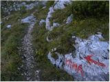 56
56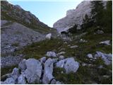 57
57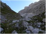 58
58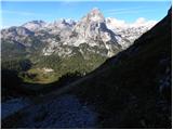 59
59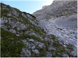 60
60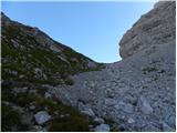 61
61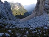 62
62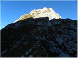 63
63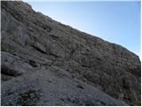 64
64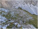 65
65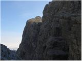 66
66 67
67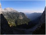 68
68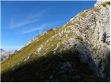 69
69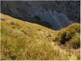 70
70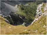 71
71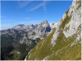 72
72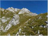 73
73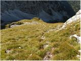 74
74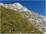 75
75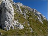 76
76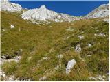 77
77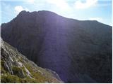 78
78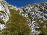 79
79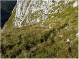 80
80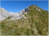 81
81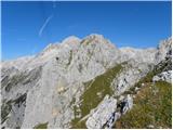 82
82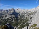 83
83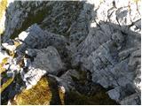 84
84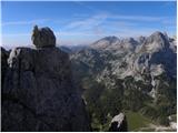 85
85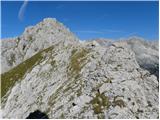 86
86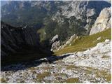 87
87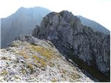 88
88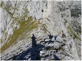 89
89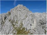 90
90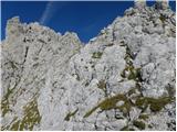 91
91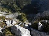 92
92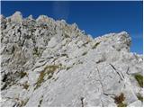 93
93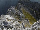 94
94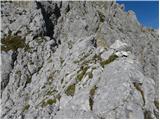 95
95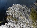 96
96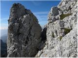 97
97 98
98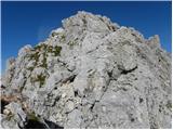 99
99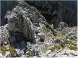 100
100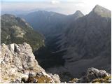 101
101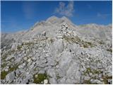 102
102
Discussion about the trip Konec ceste na Pokljuki - Vernar
|
| Jože.15. 09. 2010 |
Yesterday at the summit. No living soul anywhere, except a couple of marmots. View unique.
|
|
|
|
| netline10. 08. 2014 |
Ascent to Vernar is a nice experience. When viewed from below from the trail to Vodnikov dom, it looks steep and unconquerable.
From Bohinjska vratca it looks more human, and once climbing it, even a bit easier. There is little climbing and it's easy. The rock is quite good with very rare loose spots. After 10h in summer, the dew is mostly dried and the risk of slipping is lower. Given some shattered rocks, there is probably high lightning risk on the ridge.
Personally, the ascent to Vernar seemed much easier (orientation and technically) than the ascent to Tosc via the hunting trail from Bohinjska vratca.
|
|
|
|
| ločanka10. 08. 2014 |
The problem is not one of orientation, but of exposure in the section between the sub-summit and the main summit. I fully agree with the route description, especially the last paragraph.
A few years ago we walked here with children and even today I shudder at the thought of how much we really risked.
|
|
|
|
| katja874. 11. 2014 |
On Sunday we did a wonderful circular tour: End of the road on Pokljuka - Jezerce - Studorski preval - Vodnikov dom - Bohinjska vratca - Vernar - Bohinjska vratca - Tosc (off-trail through the NW wall) - Studorski preval - Jezerce - Pokljuka. We needed 11 hours for the entire tour, with longer stops at the summits.
The entire path was dry, except for the section from Jezerce to Studorski preval and individual crossings in the NW wall of Tosc.
The path to Vernar is extremely beautiful, scrambling along the ridge is really adrenaline-pumping. The summit offers beautiful views, especially of the neighboring Triglav 
More photos and tour description are published on the website of Planinsko društvo Matica Murska Sobota: http://www.pdmaticams-drustvo.si/
|
|
|
|
| MPS7. 11. 2020 |
Last week I went to Vernar from Pokljuka. The path was without any special features, there was no more snow on the more demanding sections.
For a better idea of the path, I recorded and compiled a short video, which you can watch at the link: Vernar, Julian Alps, October 2020
I hope it will be helpful to someone. 
Safe steps and good luck, Mirko
|
|
|
|
| velkavrh8. 11. 2020 |
MPS wonderfully filmed! Unfortunately, I must note that it is not safe to climb Vernar without a helmet. I have been up there three times. And great music too - I don't know the performer.
|
|
|
|
| MPS9. 11. 2020 |
Thanks, velkavrh. I agree about the helmet. I usually have it on my head, but that day I forgot it. The song in the video is by Eddie Vedder, singer of Pearl Jam.  Good luck. Good luck.
|
|
|
|
| bo_zl10. 07. 2024 17:42:35 |
I recommend the path to all who like peace. Of course from Vodnikov dom onwards. The last 15 minutes are perfect for those who like narrow, exposed, unsecured ridges. Some cairns also show the right direction, I enlarged all I saw by a stone or two.
|
|
|
|
| Darxta11. 08. 2025 10:27:51 |
Yesterday we from PD Medvode ascended to Vernar starting from Rudno polje. The path from Bohinjska vrata to the pre-summit is steep but easily followable. The rocky ridge section from pre-summit to Vernar is quite adrenaline-pumping, but it was easier for us because the guide showed the best route over the rocks, which weren't too crumbly.
Helmet is highly recommended, and if you're going in a group, it's practically mandatory due to sections where someone is above/below you and a stone can be dislodged.
|
|
|
To post a comment you must log in:
If you do not yet have a username, you must first
register.