Konec ceste na Pokljuki - Viševnik (via Srenjski preval)
Starting point: Konec ceste na Pokljuki (1312 m)
| Latitude/Longitude: | 46,33860°N 13,90450°E |
| |
Route name: via Srenjski preval
Walking time: 2 h 15 min
Difficulty: partly demanding marked way
Elevation gain: 738 m
Elevation difference along the route: 740 m
Map: Triglav 1:25.000
Recommended equipment (summer):
Recommended equipment (winter): ice axe, crampons
Views: 40.401
 | 3 people like this post |
Access to starting point:a) Leave the Gorenjska motorway at the Lesce exit, then follow signs for Bled and Pokljuka. Continue through Gorje and past the Zatrnik ski slope to Rudno polje on Pokljuka, where there is a large paid parking lot, nearby also military barracks and shooting range. From here continue straight on the gravel road, which a bit further brings us to a junction, where we continue right (left Uskovnica). Follow this road to the former parking lot Za Ribnico, located at the end of the road (nearby are mountain signs for planina Konjščica).
Now parking at the end of the road is prohibited, so park already at Rudno polje, which extends the route by about 40 minutes, but it is more appropriate to choose the marked path that starts already at Rudno polje.
b) From Železniki or Podbrdo drive to Bohinjska Bistrica, then continue driving towards Bled. Shortly after the Petrol gas station, located just behind Bohinjska Bistrica, continue left towards Pokljuka and Jereka. The road first ascends steeply, then after Koriti gradually flattens and brings us to a junction at the bus stop, where we continue right towards Pokljuka, Koprivnik and Jereka (straight Srednja vas). Immediately after the junction we arrive in Jereka; from the junction in front of the church, we continue straight towards Pokljuka (left Podjelje). After Jereka the road starts to ascend more steeply again, higher it flattens and continues along Mrzli potok. When we join the road from Bled, go left and drive to Rudno polje, where there is a large paid parking lot, nearby also military barracks and shooting range. From here continue straight on the gravel road, which a bit further brings us to a junction, where we continue right (left Uskovnica). Follow this road to the former parking lot Za Ribnico, located at the end of the road (nearby are mountain signs for planina Konjščica).
Now parking at the end of the road is prohibited, so park already at Rudno polje, which extends the route by about 40 minutes, but it is more appropriate to choose the marked path that starts already at Rudno polje.
Traffic regime in the Pokljuka and Uskovnica area from 15.6. to 15.10.
Route description:
From the former parking lot at the end of the road, continue on the wide and initially ascending cart track in the direction of planina Konjščica. The cart track, which immediately enters dense forest, soon flattens and after a few minutes of easy walking turns into a footpath that continues along the left bank of the Ribnica stream. When the path gets very close to the mentioned stream, it turns slightly right and ascends more steeply. Higher up, the path flattens and leads us from the forest to the lower edge of the vast planina Konjščica. Here the path turns slightly left, crosses a streamlet and after a few more steps brings us to the cheese dairy on planina Konjščica.
From the cheese dairy continue on the pleasant path that in a few minutes of gentle ascent brings us to the upper edge of the planina. Here the path enters a belt of dwarf pines and shrubs and gradually starts to ascend more steeply. In the upper part of the ascent towards Jezerce, the path from Rudno polje joins us from the right, we continue straight on the moderately steep path that in a few more minutes of walking brings us to Jezerce, where the path flattens and forks. Here there are also signposts that direct us right following the signs »Viševnik« (left Triglav).
Continue first on a flat path in the direction towards Mali Draški vrh. The path then turns a bit more to the right and starts ascending through the valley between Mali Draški vrh and Viševnik. Initially we ascend on the left side of the valley, in the upper part the path turns slightly right and follows the ascent along the crumbly slope to Srenjski preval.
From Srenjski preval continue right (straight down Rudno polje and Lipanca, left Studorski preval and Mali Draški vrh) on the path that transversely ascends across a relatively crumbly slope (danger of slipping). Higher the path crosses to the western side of the ridge and flattens somewhat. Follow the transverse ascent on the path that runs along the main ridge of Viševnik. Just a few meters below the summit, the path crosses a short exposed ledge, then without major difficulties we step onto the summit of Viševnik.
Starting point - Planina Konjščica 0:30, Planina Konjščica - Klanci 0:40, Klanci - Jezerce 0:05, Jezerce - Srenjski preval 0:35, Srenjski preval - Viševnik 0:25.

Photos:
 1
1 2
2 3
3 4
4 5
5 6
6 7
7 8
8 9
9 10
10 11
11 12
12 13
13 14
14 15
15 16
16 17
17 18
18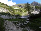 19
19 20
20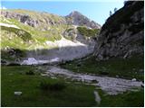 21
21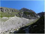 22
22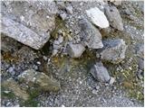 23
23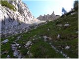 24
24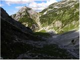 25
25 26
26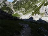 27
27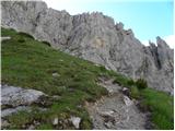 28
28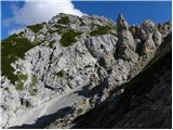 29
29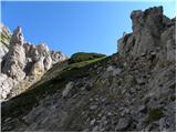 30
30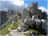 31
31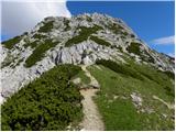 32
32 33
33 34
34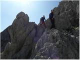 35
35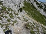 36
36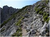 37
37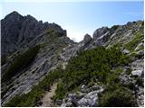 38
38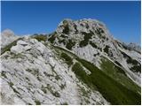 39
39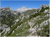 40
40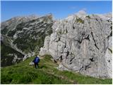 41
41 42
42
Discussion about the trip Konec ceste na Pokljuki - Viševnik (via Srenjski preval)
|
| SunBurned11. 04. 2015 |
Nice video, although you didn't have the best luck with the weather
But it should be noted that it's not uploaded to the right topic, because the video shows the easiest and shortest path to Viševnik (especially for winter). In this topic, however, the path described is one that ordinary hikers don't take in winter. Especially the ascent from Jezerca is harder than the ascent from the ski slope.
|
|
|
|
| Hribolazec8114. 08. 2023 21:51:29 |
Hi, how is this starting point, can you still get there and park?
|
|
|
|
| blazek3315. 08. 2023 21:44:57 |
At the junction of the forest road towards planina Konjščica, a new traffic sign prohibiting traffic for all vehicles (except for landowners and forest management) has been erected.
|
|
|
|
| turbo16. 08. 2023 06:22:05 |
Hribolazec81, make an effort and peek at a couple of forums, instead of asking the same thing in multiple places, the answer to your question was already posted a few days ago, even with an attached photo.
|
|
|
To post a comment you must log in:
If you do not yet have a username, you must first
register.