Konec ceste - Rogatec (climbing way)
Starting point: Konec ceste (1000 m)
| Latitude/Longitude: | 46,31180°N 14,74910°E |
| |
Route name: climbing way
Walking time: 1 h 25 min
Difficulty: very difficult marked way
Elevation gain: 557 m
Elevation difference along the route: 565 m
Map: Kamniške in Savinjske Alpe 1:50.000
Recommended equipment (summer): helmet
Recommended equipment (winter): helmet, ice axe, crampons
Views: 39.195
 | 7 people like this post |
Access to starting point:
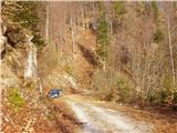
From Kamnik we drive towards Gornji Grad. At the chapel just a few dozen meters before Gornji Grad we turn left (direction Sveti Lenart). Further we drive on the road which goes along the stream upwards. The road then leaves the stream and brings us to a decaying wooden shack, where we continue ahead on the road towards the church. At the crossroad a few meters below the church we go left and follow the road, which makes a sharp right turn, to its end, where we park.
From the Štajerska side we first drive to Gornji Grad and follow the road ahead in the direction of Kamnik. Immediately after Gornji Grad we turn right (direction Sveti Lenart). Further, follow the above description.
Route description:
From the end of the road we cross a torrent and immediately after that the path steeply ascends and in zigzags brings us to an indistinct ridge. The path ahead ascends through the forest quite steeply upwards. After a good 20 minutes of ascent the steepness eases and the path in traversing brings us below the Kal saddle. A shorter ascent follows on a mostly muddy trail (exceptions are longer dry periods), which after a good five minutes brings us to the pastures on the Kal saddle. Just a few dozen meters to the right there is also a marked junction. We head straight following the Rogatec signs. The left path leads to the bivouac, which is just a few dozen meters distant from the junction. The right path leads to the mountain pasture Zg. Špeh.
The path then brings us into the forest, where there is also a sign »very demanding path«. The path turns slightly to the left and brings us to the entry into the climbing part of the path. The path steeply ascends the slope, which is partly rocky partly covered with grass, and then turns slightly to the right. It continues steeply ascending through sparse forest and brings us to the ridge, where a very nice view of the Kamnik Alps opens up. We head left, where at the beginning some pegs also assist us, then we ascend the unsecured ridge. The ridge is very panoramic in the first part, in the second part we enter the forest again through which we ascend steeply several times. Towards the end the forest becomes sparser and a few meters below the summit we come out of the forest, where a very nice view opens up again on all sides.
The climbing part of the path technically is not overly demanding, but it is not secured and therefore in wet conditions it is very dangerous for slipping.

Photos:
 1
1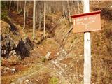 2
2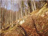 3
3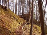 4
4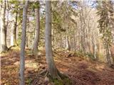 5
5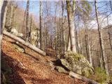 6
6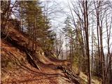 7
7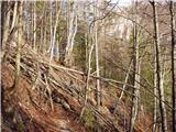 8
8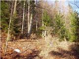 9
9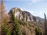 10
10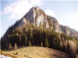 11
11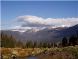 12
12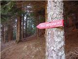 13
13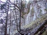 14
14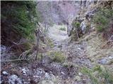 15
15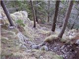 16
16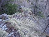 17
17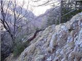 18
18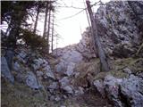 19
19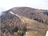 20
204424405.th.jpg) 21
21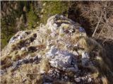 22
22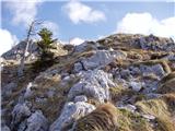 23
234424406.th.jpg) 24
244424407.th.jpg) 25
25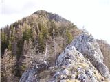 26
264424407.th.jpg) 27
27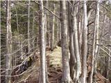 28
28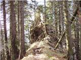 29
29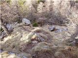 30
304424408.th.jpg) 31
31
Discussion about the trip Konec ceste - Rogatec (climbing way)
|
| lučo30. 04. 2008 |
Nice tour - highly recommend!
|
|
|
|
| nevi11. 07. 2008 |
Today my son and I went on this trail. It was nice, clear, as always in the mountains. It was very windy at Kal saddle, less so at the top, the view was great.
The hiking part is well described, the road part less so, so we got lost. The road doesn't lead to any farm, but passes under the farm, past a dilapidated wooden shack on the right and a small sign (Lenart) on the left side of the road. We drove to the farm, where the friendly owners told us to go back. Turning around in the farmyard wasn't quite easy. They probably mainly use tractors. The road also drags on quite a bit - drive from Kamnik to the starting point takes more than an hour.
|
|
|
|
| fpetel114. 08. 2008 |
Easy and pleasant climbing. Downwards it is somewhat dangerous in wet conditions and in winter. Careful with the (sparse) protections.
|
|
|
|
| pohodnik3812. 05. 2012 |
This path is quite nice though very demanding over the ridge so caution to those with vertigo I recommend the eastern path...
And some snapshots from a week ago here
|
|
|
|
| Tonika13. 05. 2012 |
Yesterday due to afternoon commitments so-called jump to Rogatec. Ideal weather conditions, light breeze during the ascent was very welcome. Simply put, we both enjoyed it; let the pictures say more.
|
|
|
|
| pohodnik3823. 05. 2012 |
Two weeks ago I walked this interesting path, locally very exposed, some snapshots in photos here.
|
|
|
|
| marinka6727. 10. 2012 |
Magnificent tour, just a shame that there are no wire ropes at the most exposed spots for safer grip. We had a 12- and 16-year-old girl with us and were a bit worried for her. Otherwise we enjoyed it!! At the top a "beach". In October we lounged at 1557m in underwear! Crazy!
|
|
|
|
| VanSims10. 06. 2013 |
The most difficult part of the path in the technical sense is where the pegs are, psychologically on the short exposed ridgelet (dizzy people naturally have no place on this path). The rest is not overly difficult for someone accustomed to difficult paths.
|
|
|
|
| irska25. 05. 2014 |
Short, varied, beautiful very demanding (ridge) tour with few safety aids. Just below the summit, the consequences of the August 2013 fire are still clearly visible and felt - especially downhill towards the Kal saddle I recommend a light step and caution to avoid dislodging rocks. A helmet despite the short very demanding section is really not superfluous.
|
|
|
|
| jimmy587. 05. 2015 |
You can no longer drive by car to the starting point (end of road) - about 300m from the church of St. Lenart there is a metal barrier! http://www.hribi.net/slike/mrk.gif
I left the car at the little church, climbed up the forest path to the upper level of the road and then to the original starting point "end of road". From there the path goes as described. If it weren't for the excessive wind from the west, it would be great.http://www.hribi.net/slike/smile.gif
|
|
|
|
| Taya157. 11. 2015 |
Yesterday we visited Rogatec via the climbing route. Great weather and views 
|
|
|
|
| garmont15. 04. 2018 |
The described path from the end of the ridge towards the Rogatec summit is difficult to pass due to fallen trees. Unlike the path from Zg. Špeh, this one can be followed and there are no major orientation issues. But advancing requires quite some gymnastics...
|
|
|
|
| rmitja21. 09. 2019 |
The path is cleaned, nicely passable and extremely well marked. But it's really not for the vertiginous. The visit is worth it because of the exceptional view. We made a circular path: church, kal, Rogatec, Špeh, church.
|
|
|
|
| razniko@gmail.com20. 05. 2020 |
Veliki Rogatec is considered a very demanding path, so I would mildly criticize the mountaineering association that maintains this path. Namely, from Mali Rogatec to V. Rogatec the passage for a few meters is very demanding, yet there is not even one peg or wire, so it represents an insurmountable obstacle for some. They could make an effort and secure these few meters better.
|
|
|
|
| dprapr20. 05. 2020 |
Isn't it enough that it is stated that it is a very demanding path?
|
|
|
|
| jprim20. 05. 2020 |
I've been on this path several times and on this very demanding path expect that you also have to free climb some sections without protection.
So you really need to think carefully before deciding on such a path.
Best regards!
|
|
|
|
| mapi6029. 06. 2020 |
On Saturday we did a circular route from Sv. Lenart to Kal and Lepenatko, then back to Kal and up the climbing path to the top of Rogatec, descending via the normal path over Zg. Špeh. The thing is, we didn't drive to the end of the road as stated, so the markings at the little church confused us quite a bit and we actually went to Zg. Špeh and branched off there to Kal. It's a good path though, because from there you go horizontally through the forest to Kal without any ascent. That unsecured section on the ridge is as it suits each person. For experienced mountaineers it doesn't pose a major problem, but for those accustomed to some very demanding paths (if well secured) we had slightly soft knees. We were 2+2.
|
|
|
|
| Andi199421. 03. 2021 |
Hi, can this same route be started on foot also from St. Lenart's church? Possibly even lower, I've never been on this path, but I'm interested because I really hate driving so high with the car.
|
|
|
|
| garmont21. 03. 2021 |
Of course it's possible. Maybe even more recommendable...
|
|
|
|
| Andi199425. 03. 2021 |
Has anyone possibly been up there in the recent time? What are the snow conditions like, or is there still a lot of snow?
|
|
|
|
| garmont1. 04. 2021 17:49:22 |
The secured path is dry. From Špeh towards the summit there's still some snow... be careful, but it's doable.
|
|
|
|
| Andi19942. 04. 2021 12:16:37 |
Last Saturday I was up there for the first time. Very nice hike, I left the car down at Rogljev mlin and walked along the road past the church of sv. Lenart and on to the end of the road then towards Lepenatka through the forest to Rogatec in a good hour. On some shaded sections especially through the forest there was still quite a bit of snow, in the climbing section it was already clear and very windy
|
|
|
|
| J.P.15. 04. 2024 16:58:24 |
Very varied, well-maintained path! Those who need additional protection should choose another approach as additional ironwork would take away all the charm of this path... Best regards
|
|
|
|
| jprim15. 04. 2024 19:54:16 |
I don't understand, how additional protection??
A self-belay kit doesn't apply, since there are no steel cables, just some pitons. The path is really airy in some places, not for those afraid of heights.
LP!
|
|
|
|
| J.P.21. 04. 2024 17:20:23 |
The essence of my comment is: don't ask for additional installation of protection (pegs and cables) but choose an approach that you are capable of
|
|
|
|
| jprim24. 04. 2024 20:18:41 |
You share very good advice.
LP!
|
|
|
|
| plaNinaPirsMajcen22. 05. 2026 19:49:45 |
Hi, I'm attaching a link to the video of this climbing route. Maybe it will be useful to someone, the key parts are recorded.
https://youtu.be/JE5rpSY6u94?is=aNKaXHCrpI-yM5VZ
We actually started at Sv. Lenart and went along the macadam road towards planina Zgornji Špeh, and a little before it we joined the marked path to sedlo Kal.
The climbing part is very varied, beautiful, spiced.
Best regards, Nina
|
|
|
To post a comment you must log in:
If you do not yet have a username, you must first
register.