Erjavčeva koča na Vršiču - Mala Mojstrovka (Hanzova pot)
Starting point: Erjavčeva koča na Vršiču (1525 m)
| Latitude/Longitude: | 46,43910°N 13,74830°E |
| |
Route name: Hanzova pot
Walking time: 2 h 25 min
Difficulty: very difficult marked way
Elevation gain: 807 m
Elevation difference along the route: 807 m
Map: Kranjska Gora 1:30.000
Recommended equipment (summer): helmet, self belay set
Recommended equipment (winter): helmet, self belay set, ice axe, crampons
Views: 17.892
 | 2 people like this post |
Access to starting point:
From Kranjska Gora on the road which leads over the Vršič pass we drive towards Bovec or vice versa. Between the 22nd and 23rd hairpin turn of the Vršič road we will get to the parking lot below the Erjavčeva koča, where we park.
Route description:
From the Erjavčeva koča na Vršiču or from the parking lot at the hut we first carefully cross the main road, then continue on the footpath in the direction of Slemenova špica, Mala Mojstrovka via Hanzova pot and Dom v Tamarju. The wide and well-trodden, mostly rocky path first ascends to the last hairpin turn on the Kranjska Gora side, where it turns slightly to the right and then relatively steeply ascends. During the ascent the path leads us through belts of dwarf pines and among rare larches. With nice views of the Špik group, Škrlatica, Prisojnik, Vršič... we soon reach a junction where we join the somewhat more frequented path from the Vršič pass.
Here we continue right and past a viewpoint a few meters away we ascend to the saddle Vratca (1799 m) in a few minutes, where the next marked junction is.
From the junction we continue left in the direction of the marked path to Mala Mojstrovka and the unmarked path towards Sleme (straight marked path towards Sleme and Slemenova špica, right unmarked path to Prednje Robičje). We leave the traverse path below the walls of Šitna glava after about ten steps and continue the ascent left onto the Hanzova pot (straight unmarked path towards Sleme). The path ahead steeply ascends with the aid of numerous pegs and higher brings us to the first steel cables, which then become our "permanent" companion. The still excellently secured path leads us steeply upwards along exposed ledges and gullies. The path, exposed to falling rocks, gradually flattens and from the left an unmarked path from Šitna glava joins us. After a further few minutes the gradient eases even more and the path brings us to more level terrain, which we skirt on the right side. Further on the path approaches the ridge, and ahead of us we spot Mangart and Jalovec. Here the path turns slightly left and brings us to a steep section of the path. With the aid of a few pegs, but mainly without fixed protection, we ascend the steep summit slope of Mala Mojstrovka to its panoramic summit.

Along the route: Vratca (1799m)
Photos:
 1
1 2
2 3
3 4
4 5
5 6
6 7
7 8
8 9
9 10
10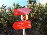 11
11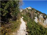 12
12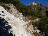 13
13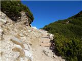 14
14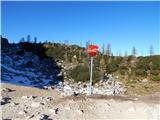 15
15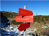 16
16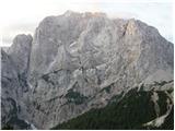 17
17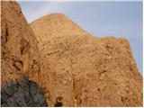 18
18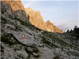 19
19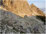 20
20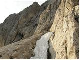 21
21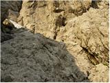 22
22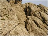 23
23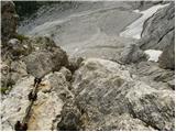 24
24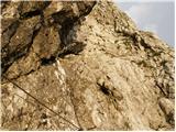 25
25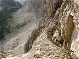 26
26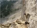 27
27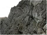 28
28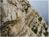 29
29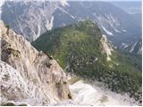 30
30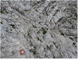 31
31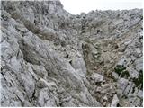 32
32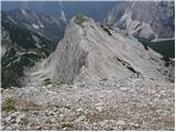 33
33 34
34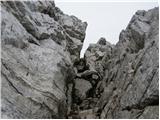 35
35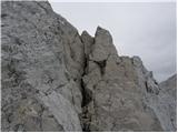 36
36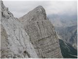 37
37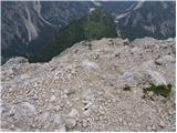 38
38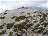 39
39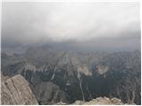 40
40
Discussion about the trip Erjavčeva koča na Vršiču - Mala Mojstrovka (Hanzova pot)
|
| mkrasev16. 08. 2015 |
hiked on Thursday 13.08. path is wonderful, nicely secured and slightly varied, fun to scramble. afternoon pleasant shade. descent southern path, scree takes you straight down. 
|
|
|
|
| masker13. 08. 2018 |
Yesterday I made the ascent to Mojstrovka, and also to Velika and the last one. Super experience. I would like to thank Katarina who offered me aid for muscle cramps. Thanks. Long live hikers and mountains.
|
|
|
|
| Slocro12. 08. 2021 23:48:34 |
masker
Was the aid for muscle cramps magnesium or something else? I have big problems with muscle cramping.
|
|
|
|
| Aljoman13. 08. 2021 07:07:07 |
For me, on longer runs, table salt helps along with adequate hydration (which is probably insufficient on hot days).
|
|
|
To post a comment you must log in:
If you do not yet have a username, you must first
register.