GEOSS - Dom Ušte - Žerenk (via Pivkelj)
Starting point: GEOSS (645 m)
| Latitude/Longitude: | 46,12030°N 14,81570°E |
| |
Route name: via Pivkelj
Walking time: 2 h
Difficulty: easy marked way
Elevation gain: 13 m
Elevation difference along the route: 285 m
Map: Ljubljana - okolica 1:50.000
Recommended equipment (summer):
Recommended equipment (winter): crampons
Views: 3.150
 | 2 people like this post |
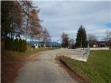
Access to starting point:
A) From the road Ljubljana - Litija, in the settlement Spodnji Hotič we turn left (from the direction of Litija right) in the direction of the settlement Vače. This is followed by an ascent to the mentioned village, from where we go left and then we follow the signs for GEOSS. In the settlement Spodnja Slivna we arrive at the inn Gostilna Vrabec, from where there is just over 100 meters of driving to the parking lot by GEOSS.
B) From the road Moravče - Izlake, in the settlement Kandrše, at Trata bar we turn right (from the direction of Izlake left) on the road in the direction of GEOSS. This is followed by some ascent, and then from the junction we continue right (left Vače) and in the next junctions as well we follow the signs for GEOSS. We park on the arranged parking lot next to GEOSS.
Route description:
From GEOSS we return to the inn Gostilna Vrabec, from there we continue left (straight Zgornja Gora and sv. Florjan) and start to ascend transversely. At the end of the right bend we leave the asphalt road and continue left on the marked footpath, which starts to ascend through the forest. Higher we emerge from the forest and at the chapel continue left and ascend to the abandoned Dom na Zgornji Slivni, where we step back onto asphalt.
From here we can in one minute ascend to the nearby church sv. Neža, from which a beautiful view opens up, otherwise we continue right and for a short time continue along the road. From the road soon a wide marked cart track branches off to the left (do not go on the road leading to the nearby transmitters), along which we continue the ascent, at junctions following the markings. Higher a marked but unmarked path from the hamlet Vrtače joins from the left, we continue slightly right, where we soon arrive at the next junction.
From the junction we continue left towards Pivkelj, to which we ascend in 5 minutes, then return to the junction and continue left (straight if we have not climbed to the top).
A little further from the cart track we go right downhill (straight to the nearby quarry Ušenišče), the descent soon ends and is followed by some more ascent. Higher the path turns left, levels out and takes us out of the forest. At the edge of the forest we continue to the macadam road, where an unmarked path joins from the right, leading past sv. Florjan.
We follow the road left, along it past the shrine we arrive at the hamlet Štance Laze, after which the road begins to descend noticeably. Before the sharp right bend a beautiful view opens up onto the surrounding hills, the macadam road lower becomes asphalt. We continue the descent, at junctions straight on. Lower the road levels out, then leads past the ranch pr Oselet, after which we go slightly right onto the path that crosses a strip of forest and quickly brings us to the Planinski dom Ušte - Žerenk.
GEOSS - Dom na Zgornji Slivni 0:30, Dom na Zgornji Slivni - Pivkelj 0:30, Pikelj - Dom Ušte-Žerenk 1:00.
Description and pictures refer to the condition in 2018 (December).

Photos:
 1
1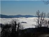 2
2 3
3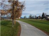 4
4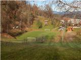 5
5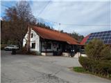 6
6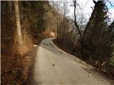 7
7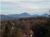 8
8 9
9 10
10 11
11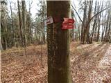 12
12 13
13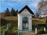 14
14 15
15 16
16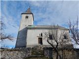 17
17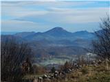 18
18 19
19 20
20 21
21 22
22 23
23 24
24 25
25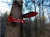 26
26 27
27 28
28 29
29 30
30 31
31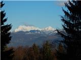 32
32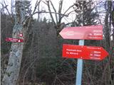 33
33 34
34 35
35 36
36 37
37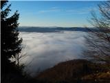 38
38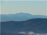 39
39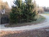 40
40 41
41 42
42 43
43 44
44 45
45 46
46 47
47
Discussion about the trip GEOSS - Dom Ušte - Žerenk (via Pivkelj)
|
| jprim4. 03. 2022 10:17:03 |
Yesterday did this trail, which is quite well described. Checked the phone several times, as markings are more for locals who find their way here on their own. Since we descended straight from the summit, we went past the quarry. Quite interesting to see up close.
Returned from the hut along the described path.
Hut pleasant, tidy, great views, pleasant caretakers.
Got to know another piece of our country.
Lp!
|
|
|
To post a comment you must log in:
If you do not yet have a username, you must first
register.