Gostišče Pekel - Pekel Gorge 5th waterfall (by canyon)
Starting point: Gostišče Pekel (350 m)
| Latitude/Longitude: | 45,89060°N 14,37200°E |
| |
Route name: by canyon
Walking time: 1 h 15 min
Difficulty: difficult marked way
Elevation gain: 220 m
Elevation difference along the route: 220 m
Map: Ljubljana - Okolica 1:50.000
Recommended equipment (summer): helmet
Recommended equipment (winter): helmet, ice axe, crampons
Views: 111.880
 | 5 people like this post |
Access to starting point:
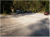
From Vrhnika or Podpeč we drive to the village of Borovnica. Here we turn into the village Brezovica pri Borovnici. Immediately when the road through the underpass crosses the railway track, we turn right. We follow this road to the parking lot at the end of the road.
Route description:
From the parking lot, we head onto the tourist path, which goes past the signs where the valley is described, first across a meadow. The path soon crosses the stream over a bridge. After some time, again over the bridge back to the right bank. The path then starts to ascend slightly and brings us to the smallest, barely 4 meters high 1st waterfall. The path then ascends and brings us to the junction. Left over the bridge is the second waterfall, which is 30 m away. We return to the junction, where we now head towards the third waterfall. During the ascent, steep well-secured stairs help us, which soon bring us to the third waterfall. Here stands a smaller decaying table from which there is a nice view towards the waterfall, which falls into a smaller pool.
The path ahead steeply ascends on longer stairs, which are exposed to falling stones. Then follow a few more pegs and the path brings us to the junction at the vantage point. We head onto the left path, which crosses a steep slope that is dangerous for slipping when wet. The path then brings us to the bridge, which we cross, and on the other side we start to ascend more steeply. The path then crosses the stream again over a bridge and brings us to the place where orientation is somewhat more difficult. Here there are a larger number of small paths, all of which except the correct one end quickly. The correct path leads left along the stream and with the help of a steel cable brings us to the 4th waterfall. The ascent further proceeds along a steep slope that requires a secure step. Then with the help of a steel cable we reach the next bridge over the stream. Here below us are smaller pools. The path ahead still ascends along a locally steep slope. The path then approaches the water again. Only a short descent to the stream follows, where a nice view opens up on the 5th waterfall.
I recommend descent via Pristava. From the 5th waterfall we cross the stream and on the other side ascend along a cart track to the road, where we turn right. After three minutes a wide marked cart track branches off to the right from the road, onto which we also turn. The cart track then after a short descent brings us to the road in the village Pristava. Further on we follow the signs for Gostišče Pekel.

Photos:
 1
1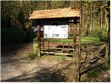 2
2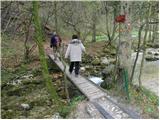 3
3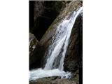 4
4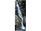 5
5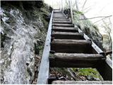 6
6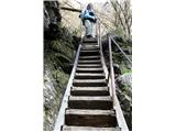 7
7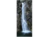 8
8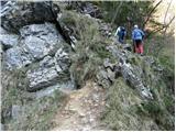 9
9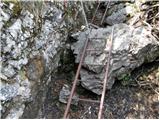 10
10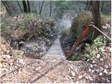 11
11 12
12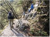 13
13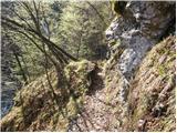 14
14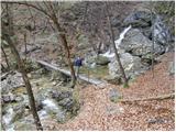 15
15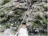 16
16 17
17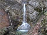 18
18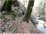 19
19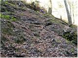 20
20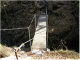 21
21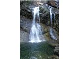 22
22
Discussion about the trip Gostišče Pekel - Pekel Gorge 5th waterfall (by canyon)
|
| Gost12. 04. 2007 |
Nice, interesting trip, I've done it several times already. Despite the initial "touristic - walking" part of the path, this is quite a demanding path, hiking boots are really necessary, trekking poles better leave at home, as they will only be in the way during ascent from the 2nd waterfall onwards.
|
|
|
|
| Gost29. 04. 2007 |
Nice hike, not touristy at all, maybe a helmet is advisable. Some wires are very poorly attached or even collapsed. Caution is never too much. Light footwear can also stay at the car.
|
|
|
|
| VanSims24. 03. 2011 |
This weekend (at least on Saturday if the weather is good  ) I would head through the Pekel gorge and onwards to Rakitna and Krim. From Rakitna onwards to Krim the description is up here. But how do you get from the 5th waterfall (Pristave or Pokojišča) to Rakitna? Does anyone know? Is the path marked? If not, where approximately to go. And are there many bears? ) I would head through the Pekel gorge and onwards to Rakitna and Krim. From Rakitna onwards to Krim the description is up here. But how do you get from the 5th waterfall (Pristave or Pokojišča) to Rakitna? Does anyone know? Is the path marked? If not, where approximately to go. And are there many bears?  Thanks! Thanks!
|
|
|
|
| katjuša224. 03. 2011 |
Some exact hiking path is probably described in booklet E6 or E7.
By road from Pokojišča to Padež, to Dobec, onwards to Kožljek, Stražišča, Otav, Rakitna....
There is also a path from Pokojišča to Padež and through Koželjski graben to Kožljek, then Stražišče,....
That's by road. I can't describe through the bushes exactly.
There are bears, and ticks too!!!!
|
|
|
|
| VanSims27. 03. 2011 |
Path description 5th PEKEL WATERFALL/POKOJIŠČE - RAKITNA:
From the fifth Pekel waterfall, follow the signs to Pokojišče. They lead us to a gravel road. There we go right and continue following the signs to Pokojišče. When we reach the intersection where we see the traffic sign for Kožljek, we head towards that place i.e. turn left (straight after about 10 minutes we reach Padno, after about 15 minutes Pokojišče).
The gravel road towards Kožljek starts descending. Eventually, if we are attentive, we notice very faded markings for the mountain path through Koželjski graben. After about half an hour of walking from the intersection, we come to a few huts (hunting lodges, weekend houses???). Ignore the bridge (even marked?!?), which branches off across the stream and leads only to the nearby clearing. Continue on the gravel past the huts.
Eventually, a small path branches left from the road (the PD responsible for this path should renew the markings and somehow mark this branch). We head onto it and after a few meters cross the stream (after rain maybe a bit annoying). Continue on the path, which runs parallel to the stream and gravel for a while and where the markings are somewhat more frequent and visible. After a couple hundred meters, we reach the gravel again and turn left.
Then we come to an intersection where we see a sign for Krimska jama to the right. Follow it (left down Brezovica pri Borovnici). The path ascends and eventually we reach a fork. Again follow the sign to Krimska jama and very sporadic and faded markings.
Follow the signs to Krimska jama to the forest path branch towards the cave where the markings come alive again and before which we see a cross on a tree, for Rakitna continue on the gravel. The path starts descending and after about a kilometer the gravel forest road ends but we don't get scared because on the left we see a marking on a tree.
Follow it and we start ascending along the bed of a weak stream. The path at the beginning is quite unpleasant (wet, mud, scree - question what it's like after heavy rain), then it improves. Follow the rarer markings to the forest path, where we exit the bed. On the forest path go right.
After about 10-15 minutes of walking, we reach gravel again where the markings lead us left. I went right on the advice of a lady, after about 20 minutes reached the Cerknica - Rakitna road. From there to Rakitensko jezero (and the plateau) it's another kilometer and a half.
I suspect that if I had gone left (the lady didn't know where this marked path leads), I would have reached directly via the forest path to Rakitensko jezero without trudging on the road. But this is just a suspicion, let someone confirm or refute it 
Time spent: less than three hours including smaller 'getting lost', asking,...
Thanks: katjuša2 for mentioning Kožljek, which led me to head towards the road to it at Pokojišče, the forester who advised the branch across the stream and the above-mentioned lady who thought Rakitna from there (approx. 45 min) was unbelievably far and who couldn't marvel enough at how much I had already walked and couldn't believe that from Rakitna I was still going to Krim.
|
|
|
|
| godlike1. 05. 2011 |
In my old stamp book (young hiker's diary) I left space for the stamp: Pekel pri Borovnici.
I was there a few years ago, but I no longer remember why there is no stamp inside.
Can someone help me where exactly I would get the stamp, because I want to go for a revisit to Pekel.
|
|
|
|
| Darko_822. 05. 2011 |
As far as I know, the stamp was stolen and they are making a new one - it should be at the 3rd waterfall.
|
|
|
|
| D-Bewc8. 05. 2011 |
The new stamp is currently still on the drawing board. We expect it to be made and installed this month at the information board at the Pekel entrance, along with the logbook.
|
|
|
|
| Dominic4. 10. 2011 |
I was up there today and the markings are really bad or none at all where you can easily miss the path, but where there is a path the markings are very good, really strange. Waterfalls are in very poor condition water-wise, I think it's drought as 4 and 5 barely have water flowing into the pools, others so-so. The path is good below, after the 5th waterfall desperately needed are gojzarji. Otherwise for inspiration there's not much more to expect.
LP
|
|
|
|
| godlike7. 05. 2012 |
I was on the circular route on April 27th, up via Hudičev zob, down as described.. New stamp is mounted at the entrance to the gorge. No logbook though, it's probably empty.
|
|
|
|
| Kokta9. 05. 2012 |
He,he. Today a different scene, brand new logbook, but no stamp anywhere. , So they said in the inn it will be back soon , So they said in the inn it will be back soon
Anyway, really varied trail that positively surprised me. Regarding the markings I agree with Domnica. Something needs to be done here, at least in the upper part. Yes, on the way back in the lower part we met two chamois as the icing on the cake . The trail is well secured.
|
|
|
|
| D-Bewc1. 07. 2012 |
Since yesterday the scene is perfect - stamp and logbook at the entrance to Pekel.
Additional signs are being installed, markings too. Structure for the new bridge at the 5th waterfall under construction.
Thanks for the applause, thanks...
|
|
|
|
| ursa.k8. 04. 2013 |
Super, yesterday it was sunny, lots of water after this rain, super nice to see!
|
|
|
|
| Kigeot5. 10. 2014 |
We followed the advice of one of the above users and went to the top of the gorge without poles. I have to say we missed them, especially on the descent, because we chose the path along the scree instead of the stairs.
|
|
|
|
| JasminaZaOvinkom7. 06. 2015 |
We used the hot day for a trip through Soteska Pekel. There is now a bit less water than after rain, but that's why the path is much safer. The kids enjoyed immensely walking on the pegs, along the steel cables and on the ladders.
The stamp is located down below - at the start of the path.
More photos at the link:
http://jasmina.zaovinkom.si/pekel/
|
|
|
|
| Ljubljana20. 06. 2017 |
The instructions in the description are incorrect:"I recommend descent via Pristava. From the 5th waterfall cross the stream and ascend on the other side along the forest road to the road, where we turn right. After three minutes a wide marked forest road branches right from the road, which we also take. The forest road then after a short descent brings us to the road in Pristava village. Further follow signs to Gostišče Pekel."
1. on the other side there is no forest road, but only a forest path that splits to Pokojišče and Hudičev zob and waterfalls.
2. Five or six people who were at the 5th waterfall at the same time neither understood nor knew the written instructions for the recommended descent via Pristava.
3. For next time we decided to go from Gostišče Pekel to Pristava and see how to get to the 5th waterfall.
Regards.
|
|
|
|
| Farki8125. 07. 2019 |
Yesterday I walked this path. The path is quite demanding in places, so flip-flops and sports sneakers are out, poles are useful only for descent if you decide to return via Pristava or along the logging trail. I chose descent via Pristava, but since there seems to be some confusion regarding this path from previous comments, I will describe it. From the 5th waterfall we continue along the right bank of the gorge, the path is marked. When we get above the waterfall, we follow the steps to the water intake, which we bypass on the left. After the water intake we cross the stream over a footbridge, then follow the marked path upstream along the stream past the mill ruins all the way to the road, where we notice direction signs. From here on we just follow the signs to gostišče Pekel, all junctions are marked with direction signs, so no orientation problems. Markings from the end of the road to Pristava are sparser and faded, but the path is clearly visible and trodden, when we arrive at the first homestead, we turn left into the yard onto the gravel road. We continue on the gravel for just a few dozen meters, where next to the farm building on the left we notice the direction sign for gostišče Pekel. The sign may be a bit hard to
|
|
|
|
| Farki8125. 07. 2019 |
notice, as it is slightly hidden in the walnut branches, so also the info that it is at the first sharp left bend. From there the path takes us after ten minutes of walking to the mill at the slightly higher gostišče Pekel.
|
|
|
|
| svetilka20. 03. 2021 |
The stamp is on the sign at the guesthouse.
Stairs, wire ropes and pegs are well maintained. Praise to PD!
Very nice and maintained path.
Wonderful nature.
But you have to be careful, it's a demanding path after all.
Between the 5th and 4th waterfall on the descent along the right bank, stick to the markers so you don't stray into the forest
|
|
|
|
| KSG21. 07. 2021 22:54:42 |
Nice and interesting trail, where hiking footwear is essential, not ordinary sneakers, All Stars etc... For dogs it's more torture than anything else... Some snapshots from the trail (July 2021) here: https://bit.ly/3wWnhpW
|
|
|
|
| KSG5. 08. 2021 22:25:26 |
Nice and interesting path, which despite lower altitude gives the impression of mid-mountains; but still need to be careful and have at least proper hiking footwear... sneakers and flip-flops no way... I agree with the predecessor that for dogs this path is more like torture and go with them somewhere else... Path conditions (July 2021) and interesting facts along the path at: https://bit.ly/2WQ5DrC
|
|
|
|
| Savinja1123. 04. 2023 19:53:06 |
Today we walked the circular path through the gorge past all waterfalls and back through Pristava. The path is excellently marked. Regarding difficulty I join the opinion of predecessors. The path can be nicely hiked, but not exactly for small children and dogs. Progress through the gorge is eased by steps, fixed ropes, pegs, but at some shorter spots greater caution is needed due to wet, steep and slippery path. Best to go up the gorge, down the easier walking path through Pristava. At the top of the path is a memorial park reminding that not everyone succeeded in ascent or return on this path. Otherwise beautiful peaceful nature with past additions (remains of old mills). Praise to all who made this path accessible to wider circle 100 years ago and maintain it diligently today. Wonderful corners of Slovenia are visited by foreigners, but they don't know what "easier path" sign at top means and head down the gorge, which is quite bad.
|
|
|
|
| Borut13. 10. 2024 15:40:53 |
I'm wondering what this trail is like a day or two after heavy rain: is it quickly passable or do the bad conditions (mud, slippery) last longer?
|
|
|
|
| Evjuna3. 10. 2024 18:51:02 |
After this rain, it will be muddy and slippery on some sections for longer than a day or two.
|
|
|
|
| Po Hodnik3. 10. 2024 19:17:28 |
Mud lasts even in mid-summer for a long time. Especially at the 4th waterfall, it's dangerous to slip downhill. Depending on the weather, I advise against it.
|
|
|
|
| bernard1112. 06. 2025 16:14:55 |
Very nice path from Gostišče Pekel to the 5th waterfall. It's not difficult, but some caution is needed, especially when the path is wet. Well marked, except at the 4th waterfall. Before it, there's a mark on a tree suggesting the right path is to the right uphill. After about 100 m I realized nothing would come of this path. At that mark, you need to go straight towards the 4th waterfall, where the path marks soon appear.
|
|
|
To post a comment you must log in:
If you do not yet have a username, you must first
register.