Gozd - Koča na Kriški gori (steep way)
Starting point: Gozd (790 m)
| Latitude/Longitude: | 46,34370°N 14,31750°E |
| |
Route name: steep way
Walking time: 1 h 45 min
Difficulty: easy marked way
Elevation gain: 681 m
Elevation difference along the route: 681 m
Map: Karavanke - osrednji del 1:50.000
Recommended equipment (summer):
Recommended equipment (winter): ice axe, crampons
Views: 84.557
 | 7 people like this post |
Access to starting point:
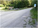
a) From the Ljubljana - Jesenice motorway, take the Kranj - west exit and continue following the road towards Golnik. Just a little after Golnik (more precisely after the settlement Senično), a steep road branches off to the right uphill towards Zgornje Vetrno and Gozd. Already shortly after the village Zgornje Vetrno, we reach a parking lot located on the left side of the road. At the end of the parking lot, the road turns right, and at the beginning of the bend, there are also mountaineering direction signs.
b) From the Jesenice - Ljubljana motorway, take the Podbrezje exit, then continue driving towards Ljubelj and Tržič. Before the Petrol gas station in Bistrica pri Tržiču, turn right and then drive into Tržič. When the road descends into the valley, continue sharply right towards Pristava and Križ, then drive along the main road leading towards Zgornje and Spodnje Duplje, leave the mentioned main road at the settlement Retnje, where we continue left towards the settlements Križe and Golnik. Continue towards Golnik, shortly after the settlement Križe, we arrive at a small junction where a steep road branches off to the left towards Zgornje Vetrno and Gozd. Already shortly after the village Zgornje Vetrno, we reach a parking lot located on the left side of the road. At the end of the parking lot, the road turns right, and at the beginning of the bend, there are also mountaineering direction signs.
Route description:
From the parking lot, continue in the direction of the steep path to Kriška gora. For a short time we still walk on a fairly gentle path, then it becomes increasingly steep. A steep ascent follows on a more or less forested path, then we arrive at an indistinct ridge where the path becomes even steeper. A few more minutes of walking through the forest follow, then the forest ends quickly and we continue the ascent on an increasingly panoramic grassy slope. With beautiful views of the Julian Alps, a large part of Gorenjska, part of the Ljubljana Basin and the Notranjska, Polhograjsko and Škofjeloško hribovje, we arrive at a bench on the upper part of the grassy slope. Above the bench, the path returns to the forest, and from the left the path from Tržič via Mala and Velika Mizica joins.
Here we continue right, then in a moderate ascent, first still through the forest, in the last part on the grassy slope, in about 15 minutes we reach Koča na Kriški gori.
Starting point - junction on the ridge of Kriška gora 1:25, junction on the ridge of Kriška gora - Koča na Kriški gori 0:20.

Along the route: Razpotje na grebenu Kriške gore (1355m)
Photos:
 1
1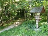 2
2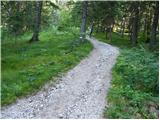 3
3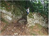 4
4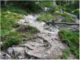 5
5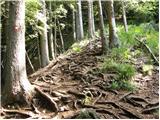 6
6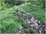 7
7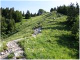 8
8 9
9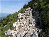 10
10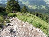 11
11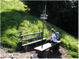 12
12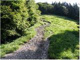 13
13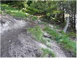 14
14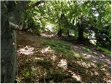 15
15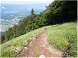 16
16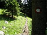 17
17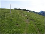 18
18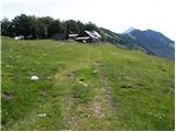 19
19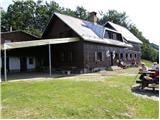 20
20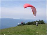 21
21
Discussion about the trip Gozd - Koča na Kriški gori (steep way)
|
| Gost9. 04. 2007 |
Really nice and interesting path, beautiful views along the way and at the top. In my opinion much nicer and more interesting than the one through Gozd village. Today there was quite a crowd on it, even bigger at the top of Kriška gora, where besides the crowd of hikers there was also a large group (or several groups, one of them from Czechia) of paragliders.
|
|
|
|
| velkavrh24. 05. 2009 |
Today in the morning hours I was on Kriška planina. Since it wasn't too hot, it was a nice hike. Unfortunately, I had a mishap-lost or stolen digital camera, it happened at the hut.It has wonderful photos from the hike around Bohinjsko jezero a week ago and also our beautiful garden.The camera was a gift for the 50th anniversary.I ask the honest finder to send the camera or inform me of the find at Predoslje 100-4000 Kranj.Thanks!
|
|
|
|
| mstrman227. 06. 2009 |
The trail is quite okay, I went from Golnik though, park behind the hospital, onwards everything is marked, walk past Gozd village (about 45 min), from there another hour to the top, a bit steep but doable.
At the top there's a wonderful view, today I got caught in rain, but later it cleared up, it was wonderful
|
|
|
|
| m30. 07. 2010 |
Hello!
Nice trail. Beautiful seats in front of the hut with great views.
Praise also for the cheese struklji and the 'big tea' served in a mug And quick service despite the large crowd (28.7.).
|
|
|
|
| amer6. 05. 2011 |
So I'll dare for the first time and write something myself: for about 3 years I've been using this website and it's really excellent - mainly thanks to good descriptions as well as opinions ratings and our contributions.
The more of us write the more interesting and useful the pages will be.
So: the trip to Kriška gora is one of the most beautiful and highly recommended for families even with small children especially on the gentle path although the steep one is completely easy. My wife and I went up the steep down the gentle so knees don't suffer too much.
Praise goes above all to the wonderful nature and view at the hut where the vast meadow with views to the Julijci creates a real fairy-tale experience.
The enthusiasm was complete about 3 weeks ago that warm April weekend when temperature at 1.500m was 20C.
But not all: thanks to the friendly hut warden a pureblood Gorenjka for excellent lunch. Only no room for struklji so we'll come again!
In my taste undeservedly this nice trip ranks only 75th in popularity,
|
|
|
|
| kakoni13. 10. 2011 |
Super trip Wonderful view and not at all strenuous path. I only missed the stamp, which could also be near the hut and not just inside the hut. We chose the trip during the week when the hut was closed 
|
|
|
|
| potočan20. 11. 2011 |
I was there today with my daughter, wonderful weather, foggy sea below.
|
|
|
|
| Bojan_A14. 04. 2012 |
Today after a long time I ran this wonderful trail again. The trail is indeed short, but nicely steep from the very beginning - real mountain running poetry. Good training before tomorrow's Mountain Run under Kriška gora.
|
|
|
|
| tk727. 10. 2013 |
Here, today we spent a wonderful day on Kriška gora, and on Tolsti vrh. The trail is really steep, but besides the beautiful view and excellent cheese struklji we also saw a herd of chamois.
|
|
|
|
| emil6613. 04. 2014 |
Can someone tell me how much snow is left on Kriška gora and if there are any fallen trees on the path due to glaze ice.
|
|
|
|
| Hurtas13. 04. 2014 |
On Kriška it has melted away, only a little on the ridge towards Tolsti vrh. Was yesterday the third time this year. The path is nicely passable. In short, up as soon as possible
|
|
|
|
| emil6614. 04. 2014 |
Thanks for the information. Hiking greetings.
|
|
|
|
| Hurtas15. 04. 2014 |
Went again this weekend from Golnik to the hut. At two places a small detour through the forest, otherwise nice along the path to the top. The snow has melted, not even on Tolsti is it visible.
|
|
|
|
| robbrt22. 03. 2019 |
Today went on the steep trail and I can say it lives up to its name. Knee-burner from the start almost to the end  along the trail, when you come out of the forest and also at the top beautiful views. along the trail, when you come out of the forest and also at the top beautiful views.
As for conditions, the trail is mostly dry, some snow patches can be found, but with some caution it goes without problem 
|
|
|
|
| sAleska1. 01. 2020 |
First day of the year, path without any ice. What weather! View gorgeous. I arrived at the top just at sunset, so I turned around quickly and was at the car already in the dark.
|
|
|
|
| MonikaG31. 03. 2021 |
I didn't expect such steepness - already from the start all the way to the top. You have to grit your teeth, no flat sections - but a great path to sweat and extra training.
Weather phenomenal, great all the time. Snow was really just a little bit in the last part in the forest in certain shades, the rest was all clear.
|
|
|
To post a comment you must log in:
If you do not yet have a username, you must first
register.