Gozd - Tolsti vrh (via Ježa)
Starting point: Gozd (891 m)
| Latitude/Longitude: | 46,34100°N 14,32830°E |
| |
Route name: via Ježa
Walking time: 2 h 15 min
Difficulty: easy marked way
Elevation gain: 824 m
Elevation difference along the route: 824 m
Map: Karavanke - osrednji del 1:50.000
Recommended equipment (summer):
Recommended equipment (winter): ice axe, crampons
Views: 69.429
 | 11 people like this post |
Access to starting point:
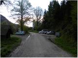
From the Ljubljana - Jesenice motorway, take the Kranj - west exit and continue following the road towards Golnik. Just a little after the village of Golnik (more precisely after the village of Senično), a steep road branches off to the right uphill towards Zgornje Veterno and Gozd. Already shortly after the village of Zgornje Veterno, we reach a marked parking lot on the left side of the road (starting point for the steep path), but we continue driving along the ascending road, which soon brings us to the Zavetišče in Gozd. We can park at one of the two larger parking lots next to the mentioned shelter, or drive another good 100 m further to the parking lot by the church.
Route description:
From the Zavetišče in Gozd, walk to the nearby church of sv. Miklavž, then reach a marked junction where the path from Golnik joins from the right. Continue left uphill along the increasingly poor road, which brings us to a junction in a few minutes.
Continue along the right track towards Storžič, Tolstega vrha, and Mala and Velika Poljana (left to Koča na Kriški gori). The track, which ascends transversely towards the east, has a few junctions in the lower section, but they are well marked so there are no major orientation problems. Higher up, the track turns into a gradually steeper footpath, which leads us from the forest to scenic grassy slopes. After a while, the path levels out and brings us to a pleasant viewpoint with a bench, next to which we notice a memorial.
Further on, the path crosses a steep grassy slope (danger of slipping and in winter also avalanche) and then enters dense forest, where we reach a marked junction. Continue left (straight to Velika and Mala Poljana via Štajnarica) towards Tolstega vrha and continue steeply uphill. The steep path, which is particularly dangerous for slipping when wet and ascends transversely to the right, brings us higher up from the forest to a scenic grassy slope, where it turns slightly to the left. A few more minutes of steep ascent follow, after which the path from Doma pod Storžičem and Mala Poljana joins from the right.
Continue left uphill towards Tolstega vrha and continue the ascent along the still quite steep path, which through a sparse belt of forest brings us to the summit slope of the mountain. Here the path levels slightly and brings us to the summit in a few minutes of further walking.
Starting point - sv. Miklavž 0:05, sv. Miklavž - junction above Gozd 0:10, junction above Gozd - Stajnar junction 1:10, Stajnar junction - junction below Tolsti vrh 0:30, junction below Tolsti vrh - Tolsti vrh 0:20.

Along the route: Zavetišče v Gozdu (891m), Sveti Miklavž (Gozd) (890m), Gozd (890m), Razpotje nad Gozdom (950m), Saškina klopca (1395m), Razpotje Stajnar (1402m), Razpotje pod Tolstim vrhom (1576m)
Photos:
 1
1 2
2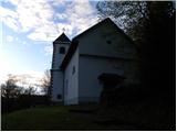 3
3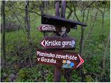 4
4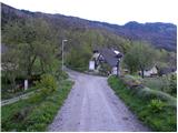 5
5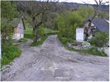 6
6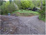 7
7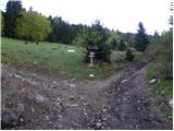 8
8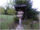 9
9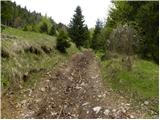 10
10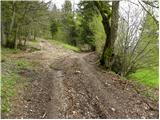 11
11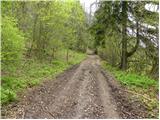 12
12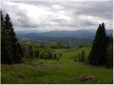 13
13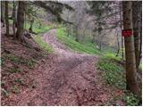 14
14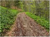 15
15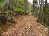 16
16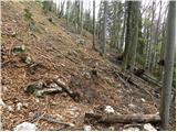 17
17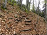 18
18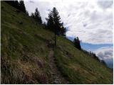 19
19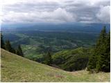 20
20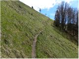 21
21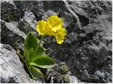 22
22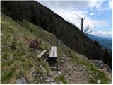 23
23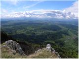 24
24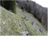 25
25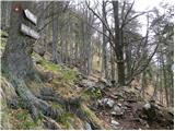 26
26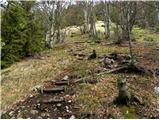 27
27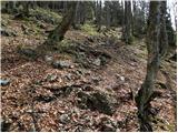 28
28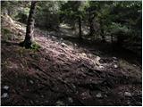 29
29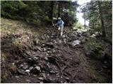 30
30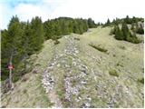 31
31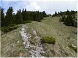 32
32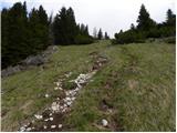 33
33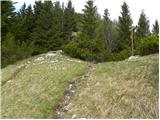 34
34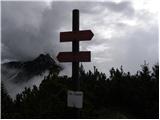 35
35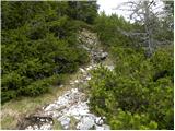 36
36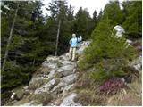 37
37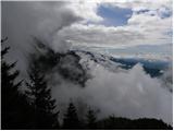 38
38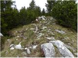 39
39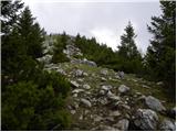 40
40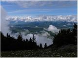 41
41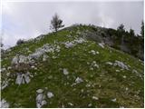 42
42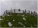 43
43 44
44
Discussion about the trip Gozd - Tolsti vrh (via Ježa)
|
| Gost9. 01. 2007 |
MT-Trip that already smells of high mountains especially the last part. Wonderful view of Storžič, the Julians with Triglav and the Košuta ridge. Towards the summit it was a bit icy. The valley was covered with a sea of clouds reaching up to about 1400m. I recommend return via the hut on Kriška gora. We basked in the sun the whole way, hard to believe I was on Tolsti vrh on 30.12.2006.
|
|
|
|
| Gost6. 02. 2008 |
Is it above the forest line or not?
It seems quite high to me. Pines aren't forest, or am I wrong? 
And in winter - is it better past the hut?
|
|
|
|
| Gost6. 02. 2008 |
The summit overlooks from the forest, the direct path from Gozd is exposed to avalanches in adverse conditions. From the hut there is usually quite a lot of snow even though it looks bare from the valley. I recommend past the hut
|
|
|
|
| Gost8. 02. 2008 |
Today we were at t. summit. Pd križe had a memorial hike with approx 150 participants from the direction of Križska gora. We from the other side direction Povlje M. polana T.Vrh. Conditions more than pleasant: Around 1000 m snow starts, higher up breakable crust underneath powder snow. Walking completely safe in both directions even without crampons. Weather couldn't be better. Unfortunately photo stayed home. Good luck to all SERA
|
|
|
|
| Nickster22. 07. 2008 |
Right on the border between forest line and high mountains
(Forest line 1600-1800 m a.s.l. in Slovenia)
Pines growing like trees are forest scrub
is no more.
lp
|
|
|
|
| velkavrh11. 08. 2008 |
Today I was up there. Now the forest path goes to the hay meadow, as they've extended it higher up. I found the previous one more pleasant, going through the forest among the trees. They've renewed the signposts, which is very commendable. Wonderful weather, beautiful views. It really tempts you to continue from there towards Storžič.
|
|
|
|
| rooney7825. 09. 2009 |
In the access description it could say right after the village of Senično there is a sign to the right GOZD. We were looking around Golnik for where to turn, thanks.
|
|
|
|
| Micky29. 08. 2010 |
Today my wife and I visited Tolsti vrh via Ježa. Interesting tour, constant ascent from this side, quite steep. Tolsti vrh is a hill that rises but not yet high mountains. The view from the summit is very nice. There were mists wrestling with clouds, but every now and then the sky cleared and the view was really magnificent. We descended via the hut on Kriška gora and back towards Gozd.
I recommend this circular variant.
|
|
|
|
| petrah77713. 09. 2010 |
On Saturday (11.09) we were at the summit with mine, quite fun......I also recommend the circular variant, because over Ježa on the logging trail there was mud for export...
|
|
|
|
| jprim13. 09. 2010 |
... with mine, with whom, ??? You know what all others can imagine, think, ...
On Saturday you were on Raduha, with whom, I'm curious, maybe some pet.
 LP! LP!
|
|
|
|
| Majdag1. 04. 2011 |
When crossing the ridge from Tolsti vrh towards the hut on Kriška gora, there are still quite a few icy sections of the path. So be careful... Majda
|
|
|
|
| Janiel7420. 05. 2011 |
Tomorrow I plan a solo on this circular path. How reliable are the weather forecasts? Don't want to get drenched Thanks
|
|
|
|
| robter20. 05. 2011 |
Now it's time to start, today clouds gathered around there already around 11 a.m.
|
|
|
|
| Janiel7421. 05. 2011 |
Successful tour! The path to Tolsti vrh via Ježa is a hundred times nicer than via Koča na Križni gori. Thanks to this site for choosing the loop. Probably dodged the rain, as it got very cloudy when I returned down.
|
|
|
|
| Janiel7421. 05. 2011 |
Must praise the very friendly service in the hut and the excellent food too!
|
|
|
|
| Breda12. 07. 2011 |
I was on Tolsti vrh on Saturday 9.7.2011. The path is nice, luckily it goes mostly through forest (it was very hot). From the top there is a great view of all corners of Slovenia, in the hut on Kriška gora I ate excellent jota , and other goodies are not lacking either. , and other goodies are not lacking either.
|
|
|
|
| pantani131. 10. 2012 |
Yesterday I was on Tolsti vrh , real winter idyll, but need to be careful as markings are poorly visible due to snowfall  !!! My colleague and I missed the marking precisely due to poor visibility (the path wasn't trodden as we were the only hikers, later Mr. Simon joined us who missed the path), so we cut across the slope to get back to the markings!!!! !!! My colleague and I missed the marking precisely due to poor visibility (the path wasn't trodden as we were the only hikers, later Mr. Simon joined us who missed the path), so we cut across the slope to get back to the markings!!!!  Weather was ideal, the hut at Kriška is open!!! Weather was ideal, the hut at Kriška is open!!!
|
|
|
|
| velkavrh30. 04. 2013 |
Today I did this path. The path to Tolsti vrh is mainly dry. Only right under the summit there is some patch of snow. Back towards Kriška gora there is still a lot of snow along the whole ridge. Fortunately the snow is just right hard so it doesn't sink and it's not icy either. Right now the evergreen gladnica is blooming on the ridge. Whole rocks are full of tiny yellow flowers - beautiful.
|
|
|
|
| Darxta2. 05. 2013 |
velkavrh, I was just about to ask about the condition. Thanks for the advance reply
|
|
|
|
| slamca21. 07. 2013 |
Today on the path from Tolsti vrh towards Kriška we found ski poles - they are not hiking poles, brand Elan MBX. Whoever lost them can get them from the caretaker at Kriška.
|
|
|
|
| Grenaleva24. 11. 2014 |
We walked this path on Saturday, practically no snow to the top, a few cm on the top, the descent to Kriška gora needs some caution as ca. 10 min walk still has some snow, well trodden but downhill requires a careful step.
|
|
|
|
| marinka6728. 04. 2015 |
Hello!
How's the snow on Tolsti vrh? We'd go up via Ježa, back via Kriška. If there's a nice day at the end of this week, of course. Snow isn't a problem otherwise, just don't want to slip anywhere
Thanks.
|
|
|
|
| Loni28. 04. 2015 |
A few days ago there were some patches in the shadier areas, mostly between Tolsti vrh and Kriška gora.
|
|
|
|
| marinka6729. 04. 2015 |
So we can set off without worry, we just need the weather, which looks like it will be quite a problem this weekend. Thanks, Loni.
|
|
|
|
| diamantek29. 04. 2015 |
marinka67, the path via both accesses (Ježa, Kriška gora) is dry, checked today. Good luck.
|
|
|
|
| marinka6729. 04. 2015 |
Oh, thanks, we're already planning the path. Unfortunately, we'll spend more time driving to the starting point than the path to the summit takes, but it was still worth it!
|
|
|
|
| SunBurned29. 04. 2015 |
Marinka67, you can easily extend the path by "incorporating" also Mala (and possibly Velika) Poljana, also Grebenc. Browse the descriptions a bit. It's worth it and in the end not substantially more strenuous than "just" Tolsti vrh. Happy trails.
|
|
|
|
| marinka6729. 04. 2015 |
Maybe I was misunderstood: to the starting point we drive 3 hours, then 2:15 to the top, back home via Kriška, another 3 hours driving home. 6 precious hours lost on the road, that annoys me.

The kids manage about 3 hours of uphill walking, so we plan such shorter tours when they are along.
But it'll be better, just as long as the weather cooperates.
SunBurned, thanks for the idea.
|
|
|
|
| Ljubljana24. 08. 2015 |
Does anyone know what happened to the fence at the top of Tolsti vrh, which can still be seen in photo No. 43, that everything is disgustingly and stinkingly shat by sheep?
|
|
|
|
| heinz24. 08. 2015 |
"Disgusting can only be 'shat' by humans. Sheep in the mountains are a natural thing.
|
|
|
|
| georgia20. 08. 2019 |
Regarding the fence at the summit - I was up there today and there's a nice new ornate wooden fence and also a new signpost, no longer like in the pictures. In short, you can nicely sit inside on the bench and elsewhere too, not so "polluted" by sheep.
By the way, along the path in the forest there's a section full of raspberries that are still waiting for someone to pick them...
Best regards from the mountains!
|
|
|
|
| KSG14. 10. 2020 |
Very nice trail with extension via Štajnarica and Mala Poljana. On the return a stop at the hut on Kriška gora, which is known for its excellent štruklji that you must try. Some snapshots from the trail (end of September 2020) can be found here: http://www.pisanezgodbe.si/kriska-gora-s-tolstim-vrhom/
|
|
|
|
| leopold1. 02. 2023 13:04:27 |
Yesterday (31.1.2023) I walked this trail in the afternoon. Currently it's for stubborn or slightly crazy folks, haven't decided yet which I fit better. The second part of the trail along the path is quite poorly trodden. I think I was the third after the last snowfall. The track is made straight to the top so it's very steep and drains a lot of strength and energy. Continuing towards Kriška up to the bench is also very poorly passable due to drifts.
Otherwise, there was a beautiful sunset on the summit and a divine evening glow that accompanied me more than half way to Kriška.
Too bad the hut at Kriška isn't open every day and there was no hot tea. But there was cold schnapps from the backpack. .
|
|
|
|
| zbil3. 04. 2023 14:37:31 |
Hello!
Has anyone walked this path in the last few days after the snowfall? Is it passable without crampons?
Thanks for the answers and happy holidays!
Safe steps
|
|
|
|
| zbil11. 04. 2023 22:23:25 |
On Friday, 7. 4., I went on this trail. The southern slopes are completely dry. The descent towards Kriška gora is demanding, on steep sections you can hardly manage without small crampons.
The weather was waau..., fantastic views in all directions.
|
|
|
|
| vampek4. 05. 2023 19:31:43 |
Has anyone gone these days from Tolsti vrh towards Kriška gora? How is it with snow on the path???
|
|
|
|
| ppegan5. 05. 2023 08:29:06 |
There has been no snow for quite some time 
|
|
|
|
| vampek5. 05. 2023 15:15:20 |
Great,
thanks
|
|
|
|
| PrimozV31. 08. 2025 18:36:32 |
Today walked the circular path + one addition Gozd - dom pod Storžičem - Tolsti vrh - koča na Kriški gori - Gozd nice tour, walking 5h20min and about 1200m elevation gain. Will repeat sometime
|
|
|
To post a comment you must log in:
If you do not yet have a username, you must first
register.