Gozdec - Visoki Kanin (via Zadnji dol)
Starting point: Gozdec (1075 m)
| Latitude/Longitude: | 46,33850°N 13,49390°E |
| |
Route name: via Zadnji dol
Walking time: 6 h
Difficulty: very difficult marked way
Elevation gain: 1512 m
Elevation difference along the route: 1615 m
Map: Julijske Alpe - zahodni del 1:50.000
Recommended equipment (summer): helmet, self belay set
Recommended equipment (winter): helmet, self belay set, ice axe, crampons
Views: 29.928
 | 2 people like this post |
Access to starting point:
We drive to the center of Bovec, where from the intersection at the main square we continue along the ascending road, which past the post office begins to climb towards the nearby church. We bypass the mentioned church on the left side, then we arrive in Kaninska vas. Bovec then ends, and the road leads us westwards for some more time. At a small junction we leave the main asphalt road which leads to the village of Plužna and continue driving along the slightly right road (after the intersection there are signs for Gozdec road). Behind the nearby homestead the road forks again, and this time we choose the slightly left road (slightly right to Zavrzelno and the starting point of the path to Rombon). We then ascend along the gravel road, which higher up brings us to the B station of the Kanin cable car. At the B station the road turns sharply left, then after approximately 1 km of further driving in a traverse ascent it brings us to the next intersection. From the mentioned intersection we continue left or straight (sharply right to planina Krnica), and we follow the road from the intersection only for a short time. Soon by the road we notice signs for Kanin, and we park about 20 meters further on a small parking lot by the road.
From Trg Golobarskih žrtev to the starting point it is approximately 9 km.
Route description:
From the starting point we return a few steps back, then we head onto the marked path in the direction of Visoki Kanin and Vrh Laške planje. The path immediately starts to ascend steeply, mostly leading us through dense forest, only occasionally opening some views of the surroundings. During the ascent the path leads us below the cliffs of Turn v Skednju (1555 m). When the cliffs end we arrive at an unmarked junction, where we continue slightly right along the marked path (slightly left unmarked path leading to Veliki Babanski Skedenj 2121 m), which soon steeply climbs over a short steep slope, where especially when wet there is a greater risk of slipping. The steepness soon eases and we arrive at the abandoned planina Gozdec, which we bypass on the right side.
Continuing we ascend through increasingly sparse forest, so some views open from the path towards the Bovec basin and Krnsko pogorje. A fairly even ascent follows, and while looking at the walls of Veliki Skedenj we arrive at a small spring located to the right by the path. Even further the easy-to-follow path is covered with grass, which can be quite wet after rain, in the morning and forenoon. After a while the path turns more towards the west and gradually becomes less steep. A few more minutes of scenic ascent follow and we arrive at the ruins of the old hut of Petra Skalarja, which burned down in 1972.
We bypass the hut on the left side, then for some time we ascend gently to moderately through more grassy terrain. The path then turns more towards the south, where some steeper ascent follows, the path slowly turns right, so in the continuation we mostly walk towards the west. A few more minutes of easy walking follow and we arrive at a marked junction, where we continue left following the signs for Kanin, to the right the path leads to Dom Petra Skalarja na Kaninu.
The path then with some shorter descents and ascents brings us again to a junction, where we turn right. To the left goes the path to Vrh Laške Planje (2448 m). The path then leads us along the valley of Zadnji dol and after some easier ascents brings us to a less visible junction.
We continue along the marked path slightly to the right. Here the path ascends somewhat more steeply, then a crossing of a scree slope slightly to the right follows, which brings us to the entrance to the more difficult part of the path. The path turns left and ascends quite steeply along an inclined gully. The path is slightly exposed in this section, and some easy climbing is also required. In the upper part we are then assisted by some pegs and wire ropes. The path then turns right and a short ascent follows on slightly scree-covered terrain to the panoramic summit.
Gozdec - Planina Gozdec 0:45, Planina Gozdec - Stara koča 1:25, Stara koča - Mali dol 0:30, Mali Dol - Veliki dol 0:25, Veliki dol - Zadnji dol 1:10, Zadnji dol - Visoki Kanin 1:45.

The trip can be extended to the following destinations: Mali Kanin
Photos:
 1
1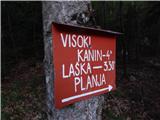 2
2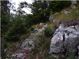 3
3 4
4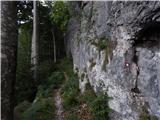 5
5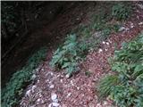 6
6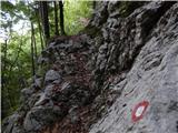 7
7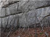 8
8 9
9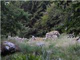 10
10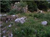 11
11 12
12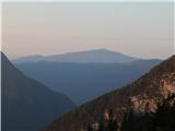 13
13 14
14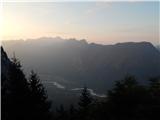 15
15 16
16 17
17 18
18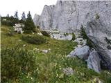 19
19 20
20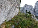 21
21 22
22 23
23 24
24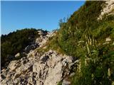 25
25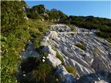 26
26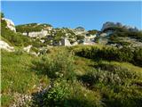 27
27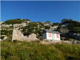 28
28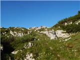 29
29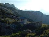 30
30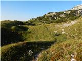 31
31 32
32 33
33 34
34 35
35 36
36 37
37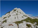 38
38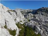 39
39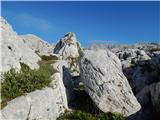 40
40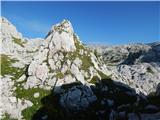 41
41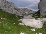 42
42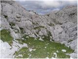 43
43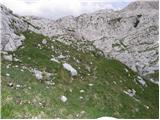 44
44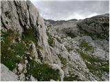 45
45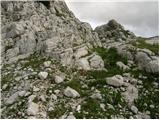 46
46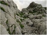 47
47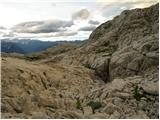 48
48 49
49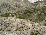 50
50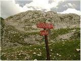 51
51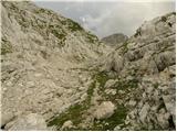 52
52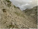 53
53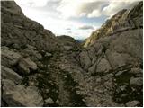 54
54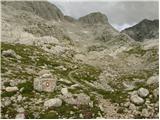 55
55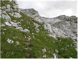 56
56 57
57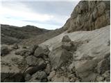 58
58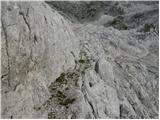 59
59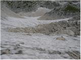 60
60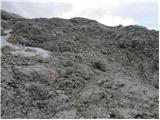 61
61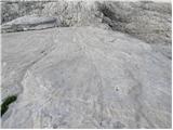 62
62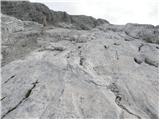 63
63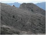 64
64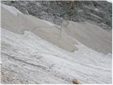 65
65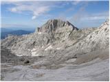 66
66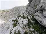 67
67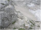 68
68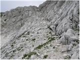 69
69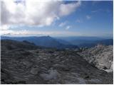 70
70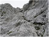 71
71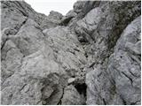 72
72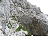 73
73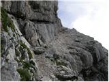 74
74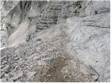 75
75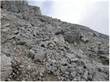 76
76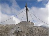 77
77
Discussion about the trip Gozdec - Visoki Kanin (via Zadnji dol)
|
| triglavski28. 07. 2008 |
I don't know who the author of the above entry is, since it's not mentioned anywhere, but the description is not accurate. At an altitude of 1814 m there are no remnants of World War I, but ruins of the old Kaninska koča (the area is outside all front lines) and from Zadnji dol, there has never been a marked trail to Mali Kanin.
|
|
|
|
| Bernarda29. 07. 2008 |
What is the path to Visoki Kanin from D station like? How is the snow? I plan to do this route next week.
|
|
|
|
| Nickster29. 07. 2008 |
OK "triglavski" the author of the text wrote: "At 1814m we see the ruins of the old Kanin hut"... and it's not wrong that these are remains from WW1!
lp
|
|
|
|
| Rok29. 07. 2008 |
The text was changed after "triglavski's" post.
LP
|
|
|
|
| navrhu2. 09. 2011 |
Maybe I'll go on this path on Sunday. I'm wondering if I can descend back to the valley by gondola and thus save time and knees?
|
|
|
|
| navrhu2. 09. 2011 |
And one more question; my wife and 5-year-old child would join. How much walking from the highest cable car station to Dom Petra Skalarja?
Would such a plan be ok; I wake up a bit earlier in the morning and drive by car to the starting point at station B, wife and child go by some public transport or on foot from Bovec to the lower gondola station? Is there any public connection between Bovec and the lower cable car station? How many meters/kilometers apart are Bovec and the lower cable car station?
Then I would plan it all so that I go to Veliki Kanin and return to Dom Petra Skalarja for lunch time, and similarly wife and daughter would arrive at the hut for lunch?
Thanks in advance for the answer. It will probably help someone else too.
|
|
|
|
| andraz8523. 09. 2012 |
I think a 5-year-old could walk this trail in good weather, maybe better to head towards Kanin, then branch left at the saddle to the hut. But I must warn that from station B it's more walking than indicated, and the last gondola leaves at 16:00... moreover, the markings completely disappear on one rocky section in Zadnji dol and we spent quite some time finding them again (keep to the right). I think no time for lunch, as it's at least 8 hours walk to the hut, and 1 hour from hut to gondola. Otherwise a very nice tour...
|
|
|
|
| ljubitelj gora19. 10. 2012 |
Tried to reach this summit today but due to a lot of snow, falling rocks from melting snow, poor markings I only observed the south wall from afar, even though it was about +10°C up there, in shady spots there is hard snow and high risk of slipping.
|
|
|
|
| stropci7. 08. 2013 |
Hi, I'm interested if the difficult part of the path is very exposed and secured with a cable? For an average hiker?
Thanks for the reply.
p.s. Also, how long would the full loop from B station towards Kanin and back clockwise past the Peter Skalar hut take?
And how demanding is the path and is there still snow in mid-August?
Thanks, best regards, Stropci
|
|
|
|
| ljubitelj gora7. 08. 2013 |
More worrying are the falling rocks higher up; if someone is right below the summit or descending, you might get a portion right on the section where the path goes. The path is exposed, it goes up a ledge and with carelessness you can quickly be lower. Cables are only below the summit, from the start to about 3/4 of the way it's unprotected easier climbing here and there with some pegs. You can go along the ridge. The path through the valley can drag on, although I don't like writing these words. Markings have faded or are missing in places, here and there are cairns and a visible trail ahead on grassy sections. The ascent to Kanin is still not easy and quite demanding, along the way there are various pits, holes and you have to be careful with them, some are 5-10 meters deep and yes . The crossing towards the hut is mostly on scree from the hut back to the junction, I don't know that section where the ruin is. For the circular B station-Kanin-Prestreljenik and back on the ski slope to B station I needed 8 hours, normally it would take about 12 hours. Maybe you can also ask user IgorZlodej, who is a local under Kanin. Last year when I went towards Kanin I didn't know where the entry was, but that doesn't bother me at all, because then I try a second, third time... You return along the ridge, or you can go up the ridge and down, so to Kanin from the Slovenian side there are two paths. . The crossing towards the hut is mostly on scree from the hut back to the junction, I don't know that section where the ruin is. For the circular B station-Kanin-Prestreljenik and back on the ski slope to B station I needed 8 hours, normally it would take about 12 hours. Maybe you can also ask user IgorZlodej, who is a local under Kanin. Last year when I went towards Kanin I didn't know where the entry was, but that doesn't bother me at all, because then I try a second, third time... You return along the ridge, or you can go up the ridge and down, so to Kanin from the Slovenian side there are two paths.
Otherwise, check out the web album above, video, pictures still tell much more than words can. This is my opinion of the path. Snow could be just in the hollows for a bit of refreshment.
|
|
|
|
| stropci11. 08. 2013 |
Thanks, mountain lover  this description helped me a lot and I'll weigh the options for this feat a bit more. this description helped me a lot and I'll weigh the options for this feat a bit more.
Just wondering if this plain climbing without cables and pegs is demanding or happens on exposed sections (possibility of quick slip).
Thanks and have a nice day
|
|
|
|
| IgorZlodej11. 08. 2013 |
I suggest doing the tour from B station to Gozdec (park at the bend, which is about 2 km further from B station, at the sharp right bend where the road to planina Krnica turns left), there are also the first markers towards the old burned hut. The path can be followed nicely all the time, also from the ruins onwards into Zadnji dol, the markers are really old, but there shouldn't be major problems, as the summit is always visible ahead. The gully in the last part is not as difficult as @Lg describes, although it's subjective and everyone sees it differently, rocks don't always fly down, it never happened to me though I've been there many times, even in winter it's one of the easiest passages to the summit. Descent along the ridge is secured at the most difficult spots, sometimes you need to grab the rock, but nothing particularly demanding, the path through Dolge prode towards Vrh Osojnice, where there is a branch to the hut (note it's closed this summer) is also marked, not at all boring, as there are nice views in clear weather, all the way to the sea. From the hut go towards Mali dol, marked, where after 45 minutes you join the path you came up on and soon you're at the ruins of the old hut, followed by descent to Gozdec to the mentioned bend at the start, where you'll probably have your car. For the whole loop I'd estimate 8-9 hours including all stops. Definitely recommend the Western Julian Alps map, where the path is nicely drawn.
|
|
|
|
| stropci14. 08. 2013 |
Thanks for this exhaustive information Igorzlodej You have helped me a lot with this and I think there won't be problems although I have already studied the path well, but every advice is welcome
Ju3 I will go to do this circular variant and report how and what
Thanks and have a nice day further
|
|
|
|
| stropci21. 08. 2013 |
Hello,
I'm writing that I successfully survived a bit of vacation in the Julians I also did this tour and I have to say it's quite interesting. Regarding the markings, they are really a bit sparse or on certain sections they are already quite poorly visible (I would appeal to renew them a bit) one part is over snowfield and if you don't know the path it's not recommended because there are many holes on these slopes that are quite deep but the tour was great weather sunny and just right strenuous for the whole loop I needed a bit less than 8 hours, even though I searched a bit for the right path before the last ascent. But it all pays off at the top so thanks for the tips and this part of Slovenia checked off
best regards stropci
|
|
|
|
| klm21. 08. 2013 |
I myself have recently been around the Kanin mountain range, both from the Bovec, Resia and Neveje side. I don't intend to describe which peaks I climbed, but I just want to express satisfaction with the "sparse markings" that I observed on the Bovec side. Especially the path from Njivice / Žaga to Velika Laška Planja excited me, which in character is similar to the one from Tamaroz to Žrd.
Given the nature of the range, more numerous markings would already be excessive.
|
|
|
|
| Daaam1. 09. 2013 |
This year's season is perfect for visiting Kanin, because the gondola is not running ..Start a bit further from B station..You can see that the path is rarely visited, higher up on the screes you have to search a bit for the line, the old and even older markings provide fun, which at times are scattered as if dropped from an airplane  ..The final ascent is really not that difficult, but I agree with LG that the problem could be rocks that can fly down from the upper part of the path (the path is really quite "loaded")-I add that this applies if you have hikers above you, which probably happens rarely. In the whole day up and down the path we met only a lady with two children who came from the direction of the hut, and were chasing the last daylight towards Bovec ..The final ascent is really not that difficult, but I agree with LG that the problem could be rocks that can fly down from the upper part of the path (the path is really quite "loaded")-I add that this applies if you have hikers above you, which probably happens rarely. In the whole day up and down the path we met only a lady with two children who came from the direction of the hut, and were chasing the last daylight towards Bovec  At the top a few visitors from the Italian approaches. My rating: fun, peace, screes occasionally "pull" a bit, but in fog I strongly advise against the trip, because if you're not really familiar with the area then you can probably just sit down in the valley (Zadnji dol) and wait for it to clear At the top a few visitors from the Italian approaches. My rating: fun, peace, screes occasionally "pull" a bit, but in fog I strongly advise against the trip, because if you're not really familiar with the area then you can probably just sit down in the valley (Zadnji dol) and wait for it to clear
|
|
|
|
| Janez_Radovljica16. 01. 2014 |
Can you help me with advice? Last year I first did the tour from B station to Visoki Kanin, and had quite a lot of orientation problems, especially in the first half. First I missed the entry to the path at "that" bend, specifically I walked from there another 15 min along the macadam. Then it became suspicious to me, and I turned right directly into the forest. After about 15 min I came across a nice forest path, I assumed it was the right path, and that I would soon come across the ruins. But they weren't there. And this path wasn't marked at all. The path, which soon turned into a mulattiera, soon began to climb into some rocks (is that Veliki Skedenj?), and at the top the path actually began to descend (as described in the instructions), but nowhere was the old Kanin hut visible. The path - which was quite wide but overgrown with grass - kept descending and descending - I had been walking downhill on the path for at least 20 minutes and 150 meters of elevation (suspicious again - online it says - slight descent??), then the path at some unmarked junction finally branched uphill (still unmarked). The path was then a bit over grass, then over rocks, and turned into an unmarked mulattiera, which I followed. After about 3 hours of walking from B station I came across a path from the right and the first mark. Can someone tell me where I was walking, and where I missed the ruins of the Kanin hut, and the junction towards Petra Skalar hut? I couldn't use the map of the western Julian Alps.
And one more question. At the end of the last valley, about 15 minutes before the scree, there is a crossroads on a smooth rock with completely faded inscriptions. There I turned right (it seemed to say Kanin), although it would have been more logical for me to go straight in the direction of the arrow... But I couldn't read which mountain to go left? Maybe Mali Kanin?
Thanks for the comment.
|
|
|
|
| Daaam16. 01. 2014 |
I can't help you much.. probably your problem is that you already missed the junction at the start (at the bend) so you then walked towards Kanin left of the marked path and consequently arrived at the Kanin slopes/last valley higher than the hut ruins.. That left junction could also have been the path to Vrh Laške Planje.. but I'm not an expert on that area so I don't dare to claim.. The path is already half overgrown, and even fewer people go there so you have to be a bit more attentive..
|
|
|
|
| klm16. 01. 2014 |
As I managed to understand, you continued from the B station along the road to the first left junction and along that branch to a more pronounced right bend, where the trail also starts. You obviously missed that. Nearby is a small parking lot and a direction sign, which is however somewhat less visible. Following it uphill you would arrive after 15 minutes at the left trail junction, the same trail you joined later: that is the unmarked mulatjera leading towards planina Baban and both Babanjski Skednji. From that junction you should have continued straight uphill past the ruins of planina Gozdec and then along the remains of the fire site of the former mountain hut.
But you obviously joined the aforementioned mulatjera later, which then climbs to the edge of the Ruše shoulder (ascending into some chasm (is that Veliki Skedenj?
|
|
|
|
| IgorZlodej16. 01. 2014 |
The junction at the bend has been well marked for years, so it's actually impossible to miss it, (the sign was sometimes on a stake, now on a spruce) and always well visible. Of course, one should prepare for the tour as for any other and then there are no problems. The trail itself is trodden, but it's true that in recent years more go to Veliki Babanjski Skedenj than to Kanin.
In Gozdec, logging tracks were made, but they don't lead all the way to the transverse mulattiera mentioned by klm which leads to VBS. I agree that the mentioned path needs renewal of markings especially from the ruins of the old hut onwards into Veliki Dol and towards V. Kanin. Since I renewed the marks on Laško Planjo years ago, I know that path is well marked, worse towards V. Kanin, in clear weather there shouldn't be problems anyway, since we see the summit all the time, but fog is another story.
|
|
|
|
| Janez_Radovljica16. 01. 2014 |
Thanks to both. I think or logically it seems to me that it will be as klm describes, meaning I went towards Planina Baban. Too bad there are no signs in that direction (later cairns appear, which sometimes disappear too), because otherwise the path is very interesting.. obviously I had some luck with orientation later...
One more question: once you're in Zadnji Dol, can you get directly to Mali Kanin, or do you have to go first to Veliki, and then 15min walk along the ridge, as described online? I'm asking because I plan to repeat the tour this year... thanks...
|
|
|
|
| IgorZlodej16. 01. 2014 |
One variant is, but not directly to Mali Kanin, but only to the ridge or Visoka Rezijanska pot, steep pathless scree, so the only marked safe variant is to V. Kanin and then to Mali, which is only 15-20 minutes away.
|
|
|
|
| darinka42. 08. 2022 13:27:19 |
No one has written anything here for a long time. Unknown path to me. Maybe some peculiarities. Regarding safety gear?
|
|
|
|
| darinka45. 08. 2022 07:05:33 |
We were on this path yesterday. All the way to the scree where you turn right, the path is well traceable. There it simply disappears. No cairns - nothing. And annoying scree. You need quite a bit of caution before reaching the final part. That interesting gully. I'd say few people go here. Quite demanding traverse over the scree to the entry into the wall. Because there's no path and the scree quickly carries you down. Markings are barely visible in the gully anymore.
|
|
|
|
| Alesb21721. 09. 2025 06:58:21 |
In good weather the path is clearly visible, full of cairns and some faded markings in between. The gully is also recognizable from afar, the traverse across the scree has a visible path in places, but the scree is really annoying.
The gully itself is not too exposed, the lower part is relatively gentle and protected, higher up it steepens a bit, but there are cables and pegs. Even higher there's a bit more scree, but nothing problematic. So overall it's much better than expected.
Not many people on this side.
|
|
|
To post a comment you must log in:
If you do not yet have a username, you must first
register.