Gozdec - Vrh Laške Planje
Starting point: Gozdec (1075 m)
| Latitude/Longitude: | 46,33850°N 13,49390°E |
| |
Walking time: 5 h
Difficulty: very difficult marked way
Elevation gain: 1373 m
Elevation difference along the route: 1470 m
Map: Julijske Alpe - zahodni del 1:50.000
Recommended equipment (summer): helmet
Recommended equipment (winter): helmet, ice axe, crampons
Views: 3.460
 | 4 people like this post |
Access to starting point:
We drive to the center of Bovec, where from the intersection at the main square we continue on the ascending road, which past the post office begins to climb towards the nearby church. We bypass the mentioned church on the left side, then arrive in Kaninska vas. Bovec then ends, and the road leads us westwards for some more time. At a smaller junction, we leave the main asphalt road leading to the village of Plužna and continue driving on the slightly right road (after the intersection, signs for Gozdec road). Behind the nearby homestead, the road forks again, and this time we choose the slightly left road (slightly right Zavrzelno and the starting point of the path to Rombon). We then ascend on the gravel road, which higher up brings us to the B station of the Kanin cable car. At the B station, the road turns sharply left, then in a transverse ascent after approximately 1 km of further driving brings us to the next intersection. From the mentioned intersection, we continue left or straight (sharply right planina Krnica), and we follow the road from the intersection only for a short time. Soon by the road we notice signs for Kanin, and we park about 20 meters further, on a small parking lot by the road.
From Trga Golobarskih žrtev to the starting point it is approximately 9 km.
Route description:
From the starting point, we return a few steps back, then head onto the marked path in the direction of Visoki Kanin and Vrh Laške Planje. The path immediately begins to ascend steeply, mostly leading us through dense forest, with only occasional views of the surroundings. During the ascent, the path leads us under the cliffs of Turna v Skednju (1555 m). When the cliffs end, we arrive at an unmarked junction, where we continue slightly right on the marked path (slightly left unmarked path leading to Veliki Babanski Skedenj 2121 m); this soon steeply climbs over a short steep slope, where especially when wet there is a greater risk of slipping. The steepness soon eases, and we arrive at the abandoned Planina Gozdec, which we bypass on the right side.
Continuing, we ascend through increasingly sparse forest, so some views open up from the path towards Bovška kotlina and Krnsko pogorje. A fairly even ascent follows, and as we look at the walls of Veliki Skedenj, we arrive at a small spring located to the right by the path. Further on, the followable path is covered with grass, which can be quite wet after rain, in the morning, and in the forenoon. After a while, the path turns more towards the west and gradually becomes less steep. A few more minutes of scenic ascent follow, and we arrive at the ruins of the old Koča Petra Skalarja, which burned down in 1972.
We bypass the hut on the left side, then for some time ascend gently to moderately on more grassy terrain. The path then turns more towards the south, where some steeper ascent follows, and the path slowly turns right, so in the continuation we walk mostly westwards. A few more minutes of easy walking follow, and we arrive at a marked junction, where we continue left following the signs for Kanin; to the right, the path leads to Dom Petra Skalarja na Kaninu.
The path then brings us with some shorter descents and ascents back to a junction. To the right, another path branches off to Dom Petra Skalarja, straight or slightly right the path leads through the Zadnji dol valley to Visoki Kanin, and we head left towards Vrh Laške Planje.
From the junction, we first ascend mostly on grassy terrain where the path is very poorly visible. The path then soon turns right and for some time runs northwest almost parallel to the path leading to Visoki Kanin. Later, the path turns somewhat left, and the terrain becomes more rocky. Continuing, we walk for quite some time on the Kaninskih podih where the path is mostly invisible, so we must pay very close attention to the marks and cairns. At some points, the path ascends more steeply, so we also need to use our hands. Later, the path turns slightly right and leads us to more scree terrain, alongside which we ascend more steeply. Along such a path, we then reach a small saddle on the left side of the summit Turn pod Laško Planjo.
Here we continue left and begin a very steep ascent on a partly grassy ridge. Considerable caution is required here, as the ascent is very steep and also dangerous for slipping. We continue along the ridge, which further on becomes somewhat less steep and again more rocky. We follow the ridge all the way to Vrh Laške Planje, which is located on the border between Italy and Slovenia.
The easiest descent is along the ascent path. One must set out for the summit in good weather, as orientation in fog is very difficult.
Gozdec - Planina Gozdec 0:45, Planina Gozdec - Stara koča 1:25, Stara koča - Mali dol 0:30, Mali Dol - Veliki dol 0:25, Veliki dol - Vrh Laške Planje 1:55

Photos:
 1
1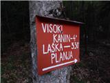 2
2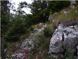 3
3 4
4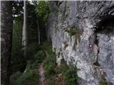 5
5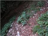 6
6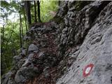 7
7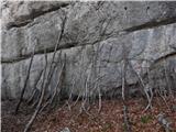 8
8 9
9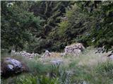 10
10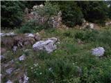 11
11 12
12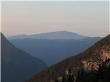 13
13 14
14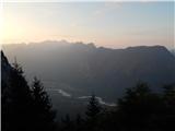 15
15 16
16 17
17 18
18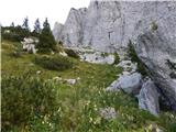 19
19 20
20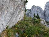 21
21 22
22 23
23 24
24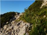 25
25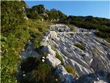 26
26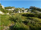 27
27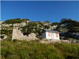 28
28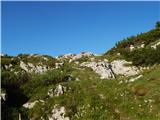 29
29 30
30 31
31 32
32 33
33 34
34 35
35 36
36 37
37 38
38 39
39 40
40 41
41 42
42 43
43 44
44 45
45 46
46 47
47 48
48 49
49 50
50 51
51 52
52 53
53 54
54 55
55 56
56 57
57 58
58 59
59 60
60 61
61 62
62 63
63 64
64 65
65 66
66 67
67 68
68 69
69 70
70 71
71 72
72 73
73 74
74 75
75 76
76 77
77 78
78 79
79 80
80 81
81 82
82 83
83 84
84 85
85 86
86 87
87 88
88 89
89 90
90 91
91 92
92 93
93 94
94 95
95 96
96 97
97 98
98 99
99 100
100 101
101 102
102 103
103 104
104 105
105
Discussion about the trip Gozdec - Vrh Laške Planje
|
| simon1611. 10. 2022 21:51:06 |
On Saturday 8.10. I did the descent on this trail from the summit of Laške Planje. On the trail via Pode there are also quite a few cairns placed between the markers, which we can follow.
Before that I ascended via another trail and visited Babanski Skedenj, Velika Baba and Vrh Žlebi.
The gravel road from Bovec to the Gozdec parking lot has seen better days and therefore needs to be driven slowly.
|
|
|
To post a comment you must log in:
If you do not yet have a username, you must first
register.