Starting point: Hrastnik (290 m)
| Latitude/Longitude: | 46,14930°N 15,08520°E |
| |
Walking time: 1 h 40 min
Difficulty: partly demanding marked way
Elevation gain: 565 m
Elevation difference along the route: 580 m
Map:
Recommended equipment (summer):
Recommended equipment (winter): ice axe, crampons
Views: 257
 | 1 person like this post |
Access to starting point:
We drive into the center of Hrastnik, where in the settlement we notice red hiking signposts for Kal and Mrzlica and a turn-off for the road towards the ski slope Rajska dolina, and park in one of the parking lots in the center of the town.
Route description:
From the parking lot in the center of the town, we head on the path towards Kal and Mrzlica, initially walking on the sidewalk by the road leading towards Kal and the Rajska dolina ski slope. At the end of the parking lot, we turn left onto Cesta Adama Dušaka, and at the first crossroad, we go right in the direction of the marked path that continues along Pot na Kal.
Further, we ascend past a few more houses, and before the last house, the path turns slightly to the left and enters the forest. We continue on the wide path, which ascends diagonally to the right, and soon arrive at a marked crossing where the path splits.
We continue straight in the direction of the path over Blate (left path over Klobuk), and a few minutes later, we return to the asphalt road leading towards Kal and the Rajska dolina ski slope.
On the road, we quickly ascend to the hamlet and saddle Blate, where at the crossroads we keep to the left direction, following the blazes.
Next follows a somewhat longer diagonal ascent on the asphalt road, which leads us along the slopes of the hill Jelenca (794 meters). When the road flattens, we turn slightly left onto a parallel mountain path, which initially continues on a poorer road that ends a few minutes later at the water reservoir.
Beyond the water supply structure, the path crosses a steep scree slope, which we ascend diagonally. When the path is damaged, this section is very dangerous for slipping; when the path is in good condition, there are no particular dangers, but some caution is still needed. Beyond the scree section, the path widens into a cart track, along which we continue ascending diagonally to the right. Higher, we turn left from the cart track and steeply ascend for a short time to the nearby macadam road, which we follow to the right, walking along it to a marked crossing on Mali Kal.
Here we continue straight across the asphalt road in the direction of Ostri vrh and Baba (left Kal and Mrzlica, right Gore, Kopitnik, and Dol pri Hrastniku) and proceed along the macadam road, which initially leads past the NOB monument.
The path ahead leads us on a macadam road that leads towards the nearby homestead; just below the homestead, we turn slightly left onto a cart track that leads us to the left of an abandoned farm, behind which we enter the forest. In the forest at the crossroads, we follow the blazes, and the path continues with some moderate ascents and short gentle descents.
As we approach Ostri vrh, an unmarked but quite well-trodden path from Krištandol joins from the right, but we follow the blazes and move onto quite steep and slippery slopes, through which we steeply ascend. This path, where extra caution is especially needed during the descent, we follow all the way to Ostri vrh, a few minutes away, where there is a stamp box.
Dol pri Hrastniku - Blate 0:40, Blate - Mali Kal 0:40, Mali Kal - Ostri vrh 0:25.

Along the route: Blate (532m), Mali Kal (760m)
Photos:
 1
1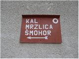 2
2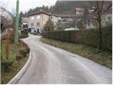 3
3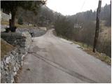 4
4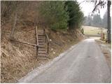 5
5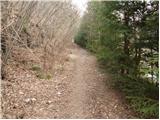 6
6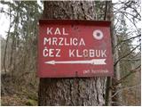 7
7 8
8 9
9 10
10 11
11 12
12 13
13 14
14 15
15 16
16 17
17 18
18 19
19 20
20 21
21 22
22 23
23 24
24 25
25 26
26 27
27 28
28 29
29 30
30 31
31 32
32 33
33 34
34 35
35 36
36
Discussion about the trip Hrastnik - Ostri vrh
To post a comment you must log in:
If you do not yet have a username, you must first
register.