Jablance - Veliki Javornik (Bohor) (via Travni laz)
Starting point: Jablance (500 m)
| Latitude/Longitude: | 46,04670°N 15,44540°E |
| |
Route name: via Travni laz
Walking time: 1 h 40 min
Difficulty: easy unmarked way
Elevation gain: 523 m
Elevation difference along the route: 600 m
Map: Posavsko hribovje Boč - Bohor 1:50.000
Recommended equipment (summer):
Recommended equipment (winter):
Views: 18.674
 | 4 people like this post |
Access to starting point:
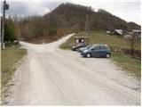
From Krško we drive towards Sevnica or vice versa. Soon after Krško, the road branches off to the right towards Brestanica (from Sevnica a little before Krško to the left). We follow this road ahead towards Senovo, where we notice the first signs for Bohor (in Senovo we turn left). The road, which then runs along the stream upwards, brings us higher to a poorly marked junction, where we continue slightly left upwards (the road which goes straight, still along the stream, brings us to the hut Koča na Bohorju. Our left road then makes two sharp turns and soon brings us out of the forest, where after an additional 100 m of driving, we park on the parking lot by the information board.
Route description:
From the parking lot, we continue on the left unmarked road, which after 10 minutes of walking brings us to the sharp left turn. In the middle of the turn, to the right along the stream upwards, a cart track branches off in the direction of the waterfall Ubijavnik. The cart track soon turns into a footpath, which several times crosses the mentioned stream and eventually brings us below the waterfall. Only a few meters before the waterfall, the path turns right and with the help of fixed safety gear steeply ascends. The ascent in snowless conditions is not demanding, but it is exposed to falling stones. At the top of this ascent we step onto the road, where we continue left. After a few more minutes of walking, the increasingly poor road crosses the stream (before the bridge to the right hut Koča na Bohorju). Here we continue on the cart track, which ascends along the stream upwards. The increasingly steep cart track soon brings us to the next junction, where we continue left in the direction of the hospital (right hut Koča na Bohorju). The path ahead crosses a torrent stream and in a short traverse ascent brings us to the partisan hospital on Travni laz.
From the hospital we continue in the direction of Javornik, on the marked path, which moderately ascends through the forest. After a short ascent, we step onto the forest road, which we follow to the left, still towards Javornik. The road along which we walk brings us, after approximately 15 minutes of walking, to a junction, where we continue right in the direction of Javornik - Bohor (left Lisca). We continue ahead on the cart track, which after a short gentle ascent brings us to the next junction, where we continue left upwards on the path, which steeply ascends for a short time and brings us in a few minutes to the summit unvegetated slope of Veliki Javornik. We follow this gentle path, which leads along the edge of the forest, all the way to the top, which we reach after a few dozen steps of further walking.

Along the route: Slap Ubijavnik (680m), Partizanska bolnica (800m)
Photos:
 1
1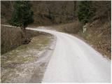 2
2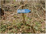 3
3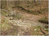 4
4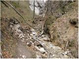 5
5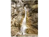 6
6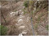 7
7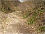 8
8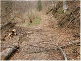 9
9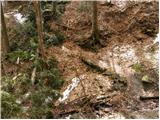 10
10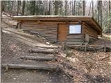 11
11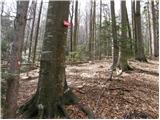 12
12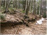 13
13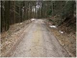 14
14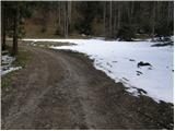 15
15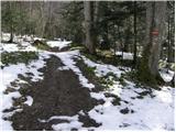 16
16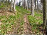 17
17 18
18 19
19
Discussion about the trip Jablance - Veliki Javornik (Bohor) (via Travni laz)
|
| lakkon20. 05. 2013 |
It says it's an easy unmarked trail. I don't have much experience with such paths. And I'll probably go alone. Are there any markers on the path so you really can't miss it? Is it recommended or even mandatory to have the description and photos of this path from here with you?
I'm not worried about the return, as I'll probably go marked to the hut and to the same starting point.
|
|
|
|
| tvodop20. 05. 2013 |
It will be fine, there are some signs but the most interesting paths are unmarked. Otherwise it's best to call someone who knows that part of Bohor. When are you going?
|
|
|
|
| lakkon20. 05. 2013 |
Probably next week in the morning Tuesday-Thursday, if the weather is OK and I don't decide for both hikes to Kum (from Podkraj ob Savi (Hrastnik)) and to Mrzlica (from Hrastnik). Whichever hike it will be, I have to finish it by 12pm because of afternoon work.
I was thinking of going this week in the afternoon, but due to other obligations and possibly bad weather (if there will be any?) I've probably missed it. Well, if there's an OK weather forecast for Wednesday or Thursday this week, I might still go. I could be at the starting point in Jablance earliest at 16:30. Return to parking just before dark a bit before 20:30. I come from Kostanjevica na Krki. On Tuesday evening I'll decide if I go on Wednesday and likewise a day later if on Thursday. I can't on weekends.
|
|
|
|
| lakkon5. 11. 2013 |
Hello.
There was quite some rain on Monday, Tuesday, none forecasted for Wednesday and Thursday.
For Thursday I'm considering visiting the "Path of Four Waterfalls" (Bojanca, Pekel, Ubijavnik, Bojavnik) + perhaps an extension to Veliki Javornik (Bohor)
Will that be the right time to see these waterfalls at least close to how they are in the pictures?
Is the mentioned path normally passable after rain with high hiking boots? Because walking directly in water for a long time doesn't seem too nice to me.
Thanks for the info.
|
|
|
|
| fpetel15. 11. 2013 |
I think it would be ok. Towards Bojanca below you need to jump over the stream a few times or find a crossing over a footbridge. Once I was with my girlfriend when there was a lot of rain. The first protections were underwater, so we found the path higher up - nothing demanding. This week there shouldn't be any problems - there wasn't much rain in this area.
|
|
|
|
| _d_6. 11. 2013 |
In this area there was just enough rain that the rocks are wet in places, leaves too (I don't have verified info, because I haven't been on this path in the last days, but based on the weather I assume). Has anyone checked the condition of the path's passability from last year's tree fall? Have they cleared it? The path is otherwise nice, interesting. I hiked it in summer a year and a half ago.
|
|
|
|
| lakkon6. 11. 2013 |
I hike alone, if necessary, quite fast. Fitness is not an issue. I'm tempted to do in one day:
PATH 1:
Jablance - Bojanca - Pekel - Igla - Ajdovske peči - Ubijavnik - Partizanska bolnica v Travnem lazu - Veliki Javornik (čez Travni laz) - Veliki Koprivnik - Bohorsko naravno okno - Petrova skala - Koča na Bohorju - Plešivec (Špic hrib) - Bojavnik - Jablance
or
PATH 2:
Jablance - Bojanca - Pekel - Igla - Ajdovske peči - Ubijavnik – Koča na Bohorju - Bohorsko naravno okno - Petrova skala - Plešivec (Špic hrib) - Bojavnik - Jablance
If I go for PATH 2, then some other time: Jablance - Ubijavnik - Partizanska bolnica v Travnem lazu - Veliki Javornik (čez Travni laz) – Skalica - Veliki Koprivnik – (Debeli vrh) – Koča na Bohorju - Jablance.
Short stops everywhere and quick photographing. Probably the most of the latter at the waterfalls, if there's something to see. Maybe I won't stop at the hut at all.
Unless I get lost somewhere, how much time would PATH1 or PATH2 take me?
Hoping for an answer today. Thanks for the help.
|
|
|
|
| lakkon9. 11. 2013 |
on Thursday I did the trail of the four waterfalls under Bohor. There was still plenty of water everywhere, so satisfied with the photos. I crossed the streams n-times without issues. From Jablance to Bojanca the second half is somewhat problematic due to fallen trees on the path, but just because of that maybe even more interesting  . To Pekel without issues, likewise onwards to Ubijavnik and koča na Bohorju. well, to the last Bojavnik then right through forest, bushes, meadows, fields.. asked a couple of locals and somehow reached the last waterfall. Not recommended without a map and route description, as it's not marked. The rest another time. . To Pekel without issues, likewise onwards to Ubijavnik and koča na Bohorju. well, to the last Bojavnik then right through forest, bushes, meadows, fields.. asked a couple of locals and somehow reached the last waterfall. Not recommended without a map and route description, as it's not marked. The rest another time.
|
|
|
|
| bruny9. 11. 2013 |
Was there perhaps  a bear sighted somewhere. Indeed, between February and April it was spotted on Bohor according to some sources, mainly in the area above Planina pri Sevnici. Also filmed at one of the hunting feeding sites. But anyway, it probably returned to Kočevsko. Nice tour, yes, need to do the western parts of Bohor sometime. Lp a bear sighted somewhere. Indeed, between February and April it was spotted on Bohor according to some sources, mainly in the area above Planina pri Sevnici. Also filmed at one of the hunting feeding sites. But anyway, it probably returned to Kočevsko. Nice tour, yes, need to do the western parts of Bohor sometime. Lp
|
|
|
|
| lakkon10. 11. 2013 |
Doesn't it seem somehow logical to you that I would mention the bear in the log if I saw it?  Between Jablance - Bojanca - Pekel - Ubijavnik I saw no one except in one village (probably Ložice). Now I don't know if due to fear of bears, unmarked path or a few obstacles. But I did think of the bear a couple of times, as I read it can be around here. Well, this time it went well. Between Jablance - Bojanca - Pekel - Ubijavnik I saw no one except in one village (probably Ložice). Now I don't know if due to fear of bears, unmarked path or a few obstacles. But I did think of the bear a couple of times, as I read it can be around here. Well, this time it went well.
|
|
|
|
| bruny10. 11. 2013 |
Of course it's logical that I would write it... the question was asked more as a joke. But it's true that these are more solitary areas and last year when I was linking Bohor from Lesično, along the path only two farmhouses and in conversation at one of the farmhouses they were somewhat scared, supposedly saw a bear a few days ago around there... I still had to get to the car anyway and connected activities around there twice later. If you studied bears on Bohor, on more solitary paths of course it's still better than as one wrote in another debate, to be in bed and even there a picture can fall on your head.
|
|
|
|
| Stamp23. 06. 2022 18:43:36 |
Description of the hike this way to Javornik, then further to Okno and Koča, but from Koča down the "classic"..
VIDEO HERE
and track and photos here on Wikipedia
|
|
|
To post a comment you must log in:
If you do not yet have a username, you must first
register.