Jermanca - Brana (via Kamniško sedlo)
Starting point: Jermanca (900 m)
| Latitude/Longitude: | 46,33490°N 14,58480°E |
| |
Route name: via Kamniško sedlo
Walking time: 3 h 45 min
Difficulty: difficult marked way
Elevation gain: 1353 m
Elevation difference along the route: 1353 m
Map: Kamniške in Savinjkse Alpe 1:50.000
Recommended equipment (summer): helmet
Recommended equipment (winter): helmet, ice axe, crampons
Views: 196.246
 | 9 people like this post |
Access to starting point:
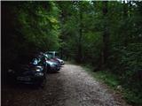
We drive to Kamnik and follow the road ahead towards the valley of Kamniška Bistrica. From the hut in Kamniška Bistrica we continue driving on the forest road which brings us higher to a crossroad, where we continue right towards Jermanca (straight starting point for Kokrsko sedlo). We follow this occasionally somewhat steeper road to the parking lot, which is located a little before the end of the road.
Driving from the mountain hut in Kamniška Bistrica to Jermanca is now forbidden (traffic sign), this extends the path for a good hour.
Route description:
From the parking lot, we continue on the road by which we've parked. After a few minutes, the road ends, and we continue on a footpath without large ascents or descents. The path which crosses a large number of gullies then joins the path from Kamniška Bistrica (lower starting point). Here we need to pay attention on the descent, that we go on the path by which we came. Well-marked and relatively steep path, which for some time still ascends through the forest, brings us higher to a pleasant spring (in dry periods dries up). From the spring a short ascent follows and the path brings us to the known resting place Pri Pastirjih, where there stands an emergency bivouac.
We continue straight on the marked path, which then quickly passes from the forest onto an ample panoramic meadow. Behind the meadow, the path goes into a belt of dwarf pines, where it starts to ascend more steeply again. The path, which continues on the increasingly panoramic sunny slope, brings us after a good hour of walking from Pastirji to the mountain hut on Kamniško sedlo.
From the hut on Kamniško sedlo we continue left in the direction of Brana on the path which through panoramic meadows brings us to a junction, where we continue slightly left (right downwards Okrešelj). The path, which further ascends on the increasingly rocky slope, quickly brings us to a scree field, which is in snow dangerous for slipping. We cross the scree in a gentle traverse ascent, then the path brings us to the next junction, where we continue left (right Turska gora).
The path then starts to ascend somewhat more steeply and for some time still crosses the slopes towards the west. The path then turns left and becomes somewhat more demanding. We then ascend on the rocky slope towards the ridge and from the path a nice view also towards Turska gora, Skuta and Grintovec starts to open up. The path then turns even more to the left and crosses steep slopes towards the southeast. On this section a steel cable helps us at some points. A somewhat steeper ascent follows through a narrower gully where some easy climbing is also needed. At the top of the gully the path turns right and a shorter ascent follows to the less steep summit slope.
We continue left and the nice panoramic and undemanding path brings us in a few minutes to the ample summit.
Jermanca - Pri Pastirjih 1:15, Pri Pastirjih - Kamniška koča 1:15, Kamniška koča - Brana 1:15.

Photos:
 1
1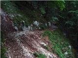 2
2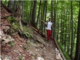 3
3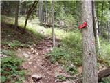 4
4 5
5 6
6 7
7 8
8 9
9 10
10 11
11 12
12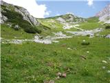 13
13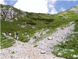 14
14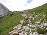 15
15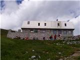 16
16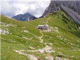 17
17 18
18 19
19 20
20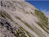 21
21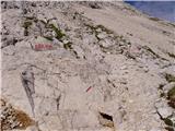 22
22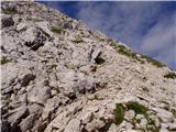 23
23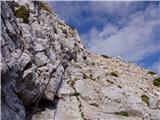 24
24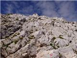 25
25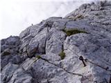 26
26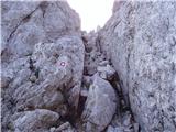 27
27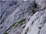 28
28 29
29 30
30
Discussion about the trip Jermanca - Brana (via Kamniško sedlo)
Show older messages
|
| Kriška1. 11. 2006 |
I did this trip about a month ago, too bad the summit was in clouds, so no views at all.
But I'd like to mention that for many (who don't have a good off-road vehicle) the path from Jermanca is already almost impossible, as it's very hard to get there with a regular car. I don't know if the path is so torn up because of torrents, lack of maintenance or something, or if they deliberately dug it up in places to prevent vehicle traffic.
|
|
|
|
| Gost14. 07. 2007 |
Today I was at Brana - the path to the summit is partly climbing - but nothing too difficult. I was very saddened because there was no stamp  or rather only the wooden handle of the stamp without the rubber part. or rather only the wooden handle of the stamp without the rubber part. If anyone from Kamniški PD reads this, please, can you put a new stamp up there. Thanks! If anyone from Kamniški PD reads this, please, can you put a new stamp up there. Thanks!
|
|
|
|
| andrej76730. 07. 2007 |
Yeah the road is really bad but that's totally fine since a real hiker starts a bit earlier from K.B. and doesn't mind those half "cheated" hours because he warms up nicely to Jermanca and then flies up to the saddle.
|
|
|
|
| fpetel130. 07. 2007 |
I also think there's no need to go everywhere by car - even from Kamniška Bistrica the trip isn't too long. Otherwise I find it a nice and cool path to Pastirji. Later we definitely sweat a bit in the sun at the scree and gravel towards Kamniško sedlo. The path to the top is nice and secured everywhere needed (three cables??? or just two)
|
|
|
|
| Gost7. 08. 2007 |
Just for those interested: 18.08. at 11am there will be holy mass at Brana. marija
|
|
|
|
| Gost28. 08. 2007 |
Nice greeting to all. On Saturday 25.8.07 we set off on this described tour and I must admit we experienced quite an unpleasant surprise. Namely those "half flattened hours" (upper comment) from KB stretched to almost 2 hours. We are average walkers but not so slow that instead of half an hour we walk 2. The mark at a little after Dom in KB is 3:45 hours. With a short stop, at least 4 hours from the hut in KB to Kamniško sedlo can be expected. Perhaps someone is really able to cover such a distance in "half an hour" (to the described starting point) but such an estimate is not objective and in my opinion ethically questionable in mountaineering terms, as it misleads. The basic path description matches both in time and descriptively. At the same time, all congratulations and praise to the editors of this site, it is very useful.
|
|
|
|
| andrej76729. 08. 2007 |
Unfortunately, you didn't read it well - I wrote this for the path from K.B. to Jermanca where many arrive by car. You can get here without problems in half an hour, then for average hikers another good 2 hours to the saddle. Nice regards.
|
|
|
|
| Gost23. 09. 2007 |
Well, I also think that the lower part of the path to Kamniško sedlo is quite boring and if you can get to Jermanca and start from there, it's fine. But it's true that there's a sign for the end of general traffic much lower down, so everyone pushes up there as they please...
To the saddle 2.5 hours? Very exaggerated estimate. From KB it's normally 4 to 4.5 hours to the saddle....
|
|
|
|
| andrej76726. 09. 2007 |
For most hikers I'm sure they reach Brana in 4.5 hours of walking without trouble, and in between enjoy half an hour for a snack at the saddle. If someone really needed 4.5 hours to the saddle, then for the nearby tour to Planjava they'd need a flashlight on the return. 
|
|
|
|
| počasni19. 06. 2008 |
Andrej767, this seems pretty silly to me. Surely you realize that some of us take more time. Besides, you'll also one day reach a state where you'll need 5 hours to the saddle and then you probably won't find yourself so witty.
|
|
|
|
| viharnik20. 06. 2008 |
For hardened mountaineers these times are really too long. For example, yesterday I took 1:40h for the ascent to Kokrško sedlo and another 1:40h to Grintovec, moderate pace. The sun was scorching too, so I stopped several times and took photos meanwhile. Best regards-ROK.
|
|
|
|
| viharnik20. 06. 2008 |
I forgot to mention also the 56-year-old gentleman, almost 20 years older than me, who overtook me on the path with times half an hour shorter each time, to whom I deeply bowed-I'd call him "mountain Joža", and best mountaineering regards!
|
|
|
|
| andrej jerina20. 06. 2008 |
Best regards to all who post on the forum like me. I think the forum is meant for something else than debating times. I check the forum and write only to get the necessary information there. Let's make sure there are no unnecessary and out-of-place words. For me, the essence of mountaineering is the PATH, regardless of the times each of us achieves. There are many of us who walk these paths, each walks and enjoys for themselves, let's respect each other. Best mountaineering regards Andrej
|
|
|
|
| viharnik20. 06. 2008 |
For the reason of providing some average walking time value for an average mountaineer, which is very important data in case of weather change or tour planning, I think that occasional discussion about times is not a bad topic - COMMENTED TRIPS and not in the CURRENT CONDITIONS forum. In fact, the PATH is certainly of primary nature and I fully agree with Andrej's message. Regards-ROK.
|
|
|
|
| Brane7120. 06. 2008 |
Times are very important, but in my opinion only for route planning. If they weren't, they wouldn't be on most signs in the mountains either. When I get an invitation from the mountaineering club for a trip, there's always info on difficulty, walking length, required equipment etc., and appropriate physical fitness is explicitly emphasized. Think what could happen if people who can only manage 6 hours of walking per day signed up for a 12-hour tour without prior information on the route length.
|
|
|
|
| a4si22. 06. 2008 |
Has anyone been to Brana in the last few days, do I still need to take ice axe and crampons or can I leave them at home?
|
|
|
|
| mad matheuss22. 06. 2008 |
Yesterday, 21.6.2008, the conditions were already almost purely summer-like. Except for some short snow patches, there is no more snow, but they are dangerous. On the descent, a hiker slipped on one of them and lightly injured his leg. With a slow and careful crossing of the stubborn remnants of winter, winter gear can be safely left at home.
|
|
|
|
| kozolec3. 08. 2008 |
Very nice path, not too demanding, requires some fitness.
|
|
|
|
| andrej mateja3. 08. 2008 |
Last weekend we were on Brana. We started from Kam. Bistrica. We had great weather. There were many hikers on the saddle, somewhat fewer on Brana. From below to the top of Brana we took 4 hours. On the saddle we stopped for the return.http://www.hribi.net/slike/wink.gif
wink
|
|
|
|
| andrej mateja3. 08. 2008 |
Oops, I made a mistake, miscalculated. To the saddle from Kam. Bistrica we took 1 hour and 58 min without stops. From the saddle to Brana exactly one hour. We had a pretty fast pace, we were pushing hard
|
|
|
|
| majamaja20. 08. 2008 |
Can someone please tell me what the road to Planina Jermance is like now? Because I would gladly 'cheat those half hours'
Thanks, LP
|
|
|
|
| MartinaZ20. 08. 2008 |
Last week it was completely OK. You just have to drive a bit slower over any potholes, otherwise it's fine.
|
|
|
|
| majamaja21. 08. 2008 |
Martina, thanks for the reply.
|
|
|
|
| majamaja10. 11. 2008 |
hi!
the same question almost three months later?
|
|
|
|
| andrej76711. 11. 2008 |
I would advise a bit more joy in walking and you'll save even more with this darling.
|
|
|
|
| Sam.volk11. 11. 2008 |
Yes, the road is still passable. LP Franc
|
|
|
|
| jprim11. 11. 2008 |
How the road is for whom is more relative, since those with higher ground clearance can still manage somehow. When my husband and I were on this path, we decided to drive last here, even though someone sped to Jermanca with a sports car. For me, it was the worst road (well, up to Podvežak they fixed it this year) as it's rutted by tire tracks and has a very steep ascent. That's my opinion, the best is for you to check it yourself and then judge from your perspective.
LP!
|
|
|
|
| majamaja13. 11. 2008 |
andrej767: what do you know, where all I've been walking these three months?!?
Thanks everyone for the answers, everything suggests (weather-wise) that in 3 months I'll ask again
|
|
|
|
| andrej76717. 11. 2008 |
In 3 months there will be looooots of snow.
|
|
|
|
| BojanGams10. 08. 2009 |
10 August. The path to Kamniško sedlo took me 1h 50min. To Brana about an hour. The path from Kamniško sedlo to Brana is not demanding, but that's relative, regarding safety a firm step and eyes on the ground are needed, because at some places the line between abyss and wall is quite thin. Good luck.
|
|
|
|
| Blaž119. 11. 2009 |
Hey, I'm interested in the conditions on the path to Brana these days, how much snow is there up top, is it normally passable? Thanks lp
|
|
|
|
| Saten26. 05. 2010 |
Tomorrow I'd like to head to Brana, but I'm curious about the snow conditions from the saddle onwards. Thanks! Lp.
|
|
|
|
| viharnik26. 05. 2010 |
Although snow in the K.S. Alps is being noticeably removed, especially from the south, on Sunday while cycling around Šmarna gora I noticed the upper part of Brana still completely snowy. From the north the mountain is very dangerous due to the scree outlet into the abyss. Snow persists there for quite a long time.
|
|
|
|
| majamaja14. 06. 2010 |
Best regards! Does anyone have information on the conditions on Brana - still any snow?
|
|
|
|
| mala planina13. 07. 2010 |
tomorrow I'll go up and write to you
|
|
|
|
| majamaja13. 07. 2010 |
now it's too late
I was at the saddle on 24 June, and the weather was really unpleasant (very cold and windy), so Brana didn't appeal to me at all ... now I don't know when I'll even get up there, so many other destinations
have a nice day, tomorrow in the mountains!
|
|
|
|
| josko3. 08. 2010 |
Is the path suitable for people who get vertigo? Thanks and best regards.
|
|
|
|
| jprim3. 08. 2010 |
I would say no, as there are two quite exposed spots.
Best regards!
|
|
|
|
| dida5. 05. 2011 |
If by chance someone walked this path recently, two things interest me:
- what is the condition of the road to Jermanca
- how much snow is still on the path, especially from the saddle onwards
|
|
|
|
| klm5. 05. 2011 |
The road to Jermanca is O.K. (I traversed it mes setopom from Kamniško sedlo on April 27), the path to the saddle is completely snow-free, but the path to Brana is still snowy (I was at the saddle on May 2), so the ascent is possible - of course - only with winter gear.
|
|
|
|
| odisej24. 05. 2011 |
On Saturday I'd like to go here, but I'm interested in the conditions, if anyone has been up there recently. Will it be possible without crampons?
|
|
|
|
| Klemenko22. 06. 2011 |
With a friend we had a very nice trip to Brana today, later it got cloudy. The trail is dry, only one patch remains on the scree on the S side, avoid it via the lower path. Helmet definitely recommended - thanks to friend for saving my head. Worth mentioning wonderful segedin at the Saddle. And apparently great herbs for tea at this time. Also one minor thing: at KB hut now a no-entry sign "Residents only". No fines judging by traffic yet, but worth admins considering (no debate intent..), if worth moving descriptions from Jermanca to Kamniška Bistrica. Good luck all!
|
|
|
|
| Klemenko22. 06. 2011 |
Pardon, I know it's already done. Check anyway. Yes, haven't been here long time, sign changed over a year ago. And fines occasional.
|
|
|
|
| bostjan8413. 07. 2011 |
With family we were on Brana on Sunday. The forest road to the parking where you can leave the car is VERY bad and very steep. The signs for the path are not exactly as written here...so we learned that you can't believe everything that's written. In addition, the beginning of the path when you start walking is not marked at all...it's a shorter part of the path, but still...otherwise we recommend the visit, it's very nice...
|
|
|
|
| ben13. 07. 2011 |
Well, you probably didn't see the sign in Kamniška Bistrica , the path start is not marked, because this path start isn't marked (map?), further on, from where it joins the path from KB !!!!
LP B
|
|
|
|
| Poda28. 11. 2011 |
Hello,
I'm interested in the conditions on Brana? Is there already snow up there?
|
|
|
|
| VanSims28. 11. 2011 |
On the southern side it's not visible from my window.
But if you're interested in the normal route from the northern side, I don't know.
|
|
|
|
| _sandra_28. 11. 2011 |
From Kamniško sedlo towards Brana there is some snow only at the beginning, because it is the northern side, but it can be crossed or bypassed. Well, at least that's how it was on 20.11.
|
|
|
|
| Marky13. 12. 2011 |
Has anyone been to Brana or at least in its vicinity in these days and knows what the conditions are like for the ascent to the summit? Thanks
|
|
|
|
| Laščan21. 06. 2012 |
I'm interested in the drivability of the road to Jermanca, any info is welcome. Thanks in advance!
|
|
|
|
| Boštjan MK21. 06. 2012 |
The road is completely fine, checked yesterday, there is a no-entry sign at the bottom anyway.
|
|
|
|
| Boštjan MK21. 06. 2012 |
Ah yes, Brana is also snow-free and without peculiarities. Good luck, Laščan!
|
|
|
|
| diamantek17. 06. 2013 |
Hello. I'm interested if the path to Brana is snow-free. Thanks.
|
|
|
|
| borutpovse17. 06. 2013 |
Hi. As far as my view reaches from home, everything looks snow-free. If something is accidentally still hidden in some shady spot, it will surely melt these days. LP
|
|
|
|
| AnzeKozjek4. 07. 2013 |
Hello! Can someone tell me what the path to Brana from Kamniško sedlo to the summit is like. Is it very exposed? Is it a precipitous path? ... Thanks!
|
|
|
|
| VanSims4. 07. 2013 |
At the beginning the scree is exposed and you have to watch your step and also not dislodge stones onto people ascending the lower path.
Later of course we look down into Logarska dolina, whether it's a bit or very exposed is hard to say. Depends on the individual.
|
|
|
|
| AnzeKozjek4. 07. 2013 |
I'm not worried about that scree or looking down into Logarska dolina. But is there any more climbing exposed section, where say you're climbing and below you there's a sheer drop of 30m or are you ascending on a quite wide path? Thanks!
|
|
|
|
| AnzeKozjek4. 07. 2013 |
Walking on the edge of a dizzying precipice - vertical say. That would be a bit of a problem for my girlfriend. But she's fine with a bit of climbing, just not too exposed a section...
|
|
|
|
| Keko4. 07. 2013 |
There is some climbing, but no excessive exposure. Nowhere do you walk on the edge of a precipice.
|
|
|
|
| Keko4. 07. 2013 |
There is some climbing, but no excessive exposure. Nowhere do you walk on the edge of a precipice.
|
|
|
|
| VanSims4. 07. 2013 |
More or less as Keko said. I agree.
|
|
|
|
| Becar4. 07. 2013 |
I recommend checking the 3rd picture posted by Tadej on the page:
Brana
I think this is the most exposed section on the entire trail; it's up to you to judge if it's passable
|
|
|
|
| VanSims4. 07. 2013 |
Becar, this doesn't hold. Anže is asking from K. sedlo onwards, but that picture is from the path to K. sedlo from Okrešelj. If he has height issues, they might choose the path from K. Bistrica or Jermanca to the sedlo, because the path from Okrešelj IS exposed!
Let me add that the hardest part, that chimney in picture 27 on this page, is not exposed.
|
|
|
|
| AnzeKozjek4. 07. 2013 |
But that 3rd picture isn't from the Jermanca - Kamniško sedlo - Brana path, if I'm not mistaken, right? That picture is from the Logarska dolina - Kamniško sedlo path...? But I think this would also go Thank you very much both!
|
|
|
|
| Becar4. 07. 2013 |
Oops, sorry, VanSims is right
|
|
|
|
| alesalen4. 07. 2013 |
Hello. Is the path suitable for a dog?
|
|
|
|
| VanSims4. 07. 2013 |
In my opinion no. To K. Sedlo from K. Bistrica or Jermanca (but not from Okrešelj) yes of course, but then no.
Perhaps not so much due to climbing sections but also due to great danger that the animal will trigger rocks on the Okrešelj - K. sedlo path.
|
|
|
|
| Ulčnik11. 08. 2013 |
To the saddle 2.5 hours? very exaggerated estimate. from KB it's normally 4 to 4.5 hours to the saddle
yesterday I went with a colleague from KB and it took us a bit more than 2.5 hours to the saddle exactly
2 45 min, and we didn't walk super fast, but had constant pace, without breaks.
|
|
|
|
| tul12. 08. 2013 |
I'm wondering if the road to Jermanca is passable.
|
|
|
|
| jezičnik13. 08. 2013 |
Driving to Jermanca is prohibited, so this question makes no sense.
|
|
|
|
| tinky13. 08. 2013 |
By the time you debate about this sign, they'll put up a barrier and a lock there. This year I've already been to Jermanca three times, and three times parked at Žagana, no problem. Jezičnik just walks on foot from Stahovce.
|
|
|
|
| Daaam13. 08. 2013 |
It's also forbidden to drive 55km/h in the settlement .. and I'm really wondering if all those who don't drive further because of the sign actually follow that. As tinky says.. really pointless to debate this, because we'll never all agree.
|
|
|
|
| pjoter15. 08. 2013 |
Soon I plan to go to the summit and I'm interested if someone can tell me the real condition of the path, whether it is demanding-as meant demanding or if it can be traversed with a bit more effort and without certain risky sections
thanks
|
|
|
|
| otiv15. 08. 2013 |
@pjoter the difficulty of the path is meant in terms of passages where there are pegs and cables that allow easier passage and we can also secure ourselves with SVK. And such is also the path to Brana from Kamniško sedlo.
Good luck!
|
|
|
|
| Maticc13. 04. 2014 |
The snow alarm says the probability of snow avalanches is negligible. But today during the ascent to Grintovec (still in the valley) from the Brana direction I heard quite strong rumbling - snow avalanche of respectable size.
Caution on the mountain (and others) won't hurt.
|
|
|
|
| pezdircc21. 07. 2014 |
Yesterday I lost my backpack on the descent from Brana. It fell on the scree that overlooks the Rinko waterfall.
If someone finds it by chance, I left personal data in the hut.
If anyone knows where else I can post the loss of the backpack, please let me know.
|
|
|
|
| janagulin3. 07. 2015 |
On Tuesday during descent I lost my Garmin oregon device. If found, I would be extremely happy if you let me know at jana.gulin@gmail.com
Thanks!
|
|
|
|
| eya16. 08. 2015 |
Hi, today I went on this path and just to say no more no-driving sign, even more now signpost for Jermanca with drawn car next to it.
Regarding exposure... I have only slight height fear, must say felt bit uncomfortable on one section, especially going up.
|
|
|
|
| SRSENKA28. 08. 2015 |
Hello, I've read a lot on the topic of dogs in the mountains. I know opinions are very divided. But still asking if the path to Brana is suitable for a shepherd dog. From the pictures, it seems only one part is exposed.. It's a trained dog and we've already been with him to Grintavec from Kokrško sedlo, to Begunjščica...
|
|
|
|
| SRSENKA29. 08. 2015 |
Got answer to the question. Today at the start of the path to Brana we turned back, because a large dog really isn't suitable given the terrain or surface. People sometimes really push with head through the wall. But it was still a nice trip to Kamniško sedlo....
|
|
|
|
| Tina7821. 10. 2015 |
Nice and heartfelt greetings to all mountain lovers...on Friday 23.10.2015 I'm heading from Jermanca via Kamniško sedlo to Brana, and I'm wondering if anyone knows what the conditions are like from the saddle onwards towards Brana...Thanks and best regards.
|
|
|
|
| skymark21. 10. 2015 |
I'm going tomorrow via Žmavcarje to the bivouac under Skuta and to Turska gora.
since this side is southern, I think some snow will melt, but I couldn't say that for the northern side of Brana. It might be unpleasant.
|
|
|
|
| loncaruros21. 10. 2015 |
I'm going tomorrow on this path to Brana... I'll write tomorrow what the path is like... I hope it will go to the top
|
|
|
|
| Tina7821. 10. 2015 |
Thanks a lot... nice regards and good luck...
|
|
|
|
| subaru21. 10. 2015 |
The northern side of Brana is snowy, icy in some parts.
Too little for crampons, risky without them.
In short, conditions for ascent are poor or dangerous.
|
|
|
|
| loncaruros22. 10. 2015 |
Today the path was done, but only to Kamniško sedlo... due to weather conditions I turned back at the saddle, because of very dense fog and wind... I didn't risk the path further, but already to the saddle the path is icy in places, but too little for crampons...
|
|
|
|
| sasgittariusvz7. 07. 2016 |
Hello, can one drive to Jermanca by car? What is the road like?
|
|
|
|
| subaru7. 07. 2016 |
You can get to Jermanca by car without problems. The road is "top" except for one bend.
|
|
|
|
| Afrofeet19. 06. 2017 |
Can someone tell me if there is a sports climbing crag near Kamniška Bistrica? I know there is some crag there, I don't know exactly where it is, how to get there and if one can by car? Thanks
|
|
|
|
| Urbban25. 06. 2017 |
You can park at the intersection where the gravel road to Kokrško sedlo goes left, right continues to Jermanca. On foot, proceed along the rutted gravel towards Lepi kamen, but already at the first bend turn right up into the forest (sign!!). Good five minutes of walking and you're at the climbing area. From the car thus less than 10 minutes walk.
|
|
|
|
| pykos25. 06. 2017 |
Yesterday my girlfriend and I went to Brana via this route. The trip was very nice and not too demanding. The path from Kam. sedlo to Brana is a bit crumbly, so a bit of caution won't hurt, and I think a helmet is recommended because during our ascent 3 families were descending with dogs. The path to the top took a total of 3h 15min (we parked in the clearing where there is a feeding spot or some mini hut), with a 15 min break at the saddle, at a leisurely pace. Overall a very nice trip and mountain.
|
|
|
|
| Zdenkob15. 08. 2017 |
Yesterday I went up this path to Brana. The road to Jermanca is drivable but in poor condition. Floods and vehicles have left evident marks. If extra walk is not too much, better park in Kam. Bistrica and walk more. Path to hut at Kamniško sedlo drags a bit but is safe, from Saddle caution is really needed as others wrote.
|
|
|
|
| danielenidoma26. 10. 2017 |
Has anyone been up there these days? Conditions? Thanks
|
|
|
|
| klemen9128. 10. 2017 |
Conditions are nothing special. Was at the top yesterday, didn't need crampons or ice axe, snow is soft and unproblematic. Today might be different because it cooled down and probably the snow from the saddle to the ridge is frozen. The ridge itself is completely bare.
|
|
|
|
| redbull28. 10. 2017 |
Today ice axe is mandatory and crampons are also recommended. Of course there's the option to go below via the scree. Good luck
28.10
|
|
|
|
| haluzow1. 11. 2017 |
Hello! Does anyone know how the snow is these days? Thanks and best regards!
|
|
|
|
| redbull2. 11. 2017 |
Somehow like it has been all week. Go check Brana under the forum conditions and you'll know everything.
Nothing is written about it here
good luck
|
|
|
|
| Frijoze21. 06. 2018 |
Yesterday I was at the summit. Conditions excellent. Praise to the guys who excellently arranged the road to Jermanca.
|
|
|
|
| Jasmina896. 07. 2018 |
Hi, can anyone advise what the weather will be like on Brana tomorrow?
I plan to go up, unless there are thunderstorms...
|
|
|
|
| Anansie6. 07. 2018 |
Don't worry, lots of us will be around there go to the saddle, if you see that the weather is BV, then have a beer and see you next time good luck!
|
|
|
|
| Jasmina898. 07. 2018 |
He he , there was enough luck yesterday .
|
|
|
|
| majsor12. 08. 2018 |
The described steep section of the trail from Kamniško sedlo to Brana is quite dangerous in my opinion and I do not recommend it to those afraid of heights or with shaky legs. I'm curious how many people actually go to Brana considering it's not an innocent mountain; there was a crowd on the trail today
|
|
|
|
| Jodlar11. 10. 2018 |
Hello. Please [provide] information, what is the road to Jermanca like. Is driving allowed? Thanks
|
|
|
|
| ForzaJuve11. 10. 2018 |
The road is still gravel
|
|
|
|
| Jodlar11. 10. 2018 |
I know it's still gravel. Last time years ago when I drove on it, it was very rough. Wondering if they've repaired it. Lp
|
|
|
|
| janez.novak11. 10. 2018 |
I don't know what forest roads some expect, but now you can drive to Jermanca in any car.
|
|
|
|
| Miha Zelenik 12. 08. 2019 |
Hi. Is the road to Jermanca drivable today or not. Fines for parking?
Thanks Miha
|
|
|
|
| julika12. 08. 2019 |
The road is nicely passable
|
|
|
|
| ljubitelj gora2. 09. 2019 |
The road was 1.9 in very good condition, the path to Kamniško sedlo is also maintained, bushes cut down. Markings Kamniško sedlo - Brana are somewhat faded. Summit book is new.
|
|
|
|
| Victorinox13. 09. 2019 |
From the saddle upwards the path is somewhat poorly marked in places. Especially in the second half of the path, at one spot you need to watch out so you don't suddenly find yourself in the middle of unsecured climbing above a drop.
|
|
|
|
| Enka27. 10. 2019 |
Refreshing the markings from the saddle to the summit would be very welcome on the descent
|
|
|
|
| Turbolazec21. 05. 2020 |
I'm interested in the conditions, has anyone been on this path recently? Sorry for also writing about Planjava, by mistake.. thanks
|
|
|
|
| Kanjanez27. 08. 2020 |
Road in normal condition = some big potholes here and there, then quite a while peaceful.
Yes, times here in KSA are really more accurate and less inflated than in the Julians.
|
|
|
|
| Climber9127. 08. 2020 |
Where in the Julians are the "inflated" times then?
|
|
|
|
| dprapr27. 08. 2020 |
Just look at the timetables of different Triglav routes, and you'll know what it's about. Similar to Mrzla gora recently.
|
|
|
|
| Turbolazec10. 12. 2020 |
Hi. For the weekend or the beginning of next week I would go to Brana, can someone tell me about the conditions, is it safe regarding avalanches? Thanks
|
|
|
|
| mosovnik11. 12. 2020 |
@Turbolazec: you're probably just kidding a bit?!!!
|
|
|
|
| Turbolazec11. 12. 2020 |
@mosovnik no, why would I be kidding?
|
|
|
|
| smatjaz11. 12. 2020 |
In the last few days, a larger amount of snow has fallen in the mountains, increasing the avalanche risk. We advise everyone who wants to visit the high mountains this weekend to change their plans and visit lower areas where there is no or less snow.
"Currently, dangers lurk in the mountain world that even the most experienced, such as mountain rescuers, mountain guides, and alpine instructors, can hardly predict." (TEXT copied FROM GRS's FB PAGE)
|
|
|
|
| Turbolazec12. 12. 2020 |
Grade 2 tomorrow for Kamnik-Savinja so we'll see
|
|
|
|
| rdemiro24. 07. 2023 10:17:32 |
Hi. Is it now allowed to drive to the parking lot in Jermanca or not?
|
|
|
|
| Janez Seliškar24. 07. 2023 12:45:53 |
The Municipal Inspectorate of Kamnik knows the answer. Just ask them.
|
|
|
|
| jturk24. 07. 2023 17:00:44 |
|
|
|
|
| PodobnikAlen4. 11. 2024 20:21:01 |
I would just say that due to the road the starting point is at 624 m a.s.l. The elevation gain is thus 1628 m and the marked time from starting point to summit is four hours and thirty minutes.
Happy trails!
|
|
|
|
| ahatimaha17. 11. 2024 08:34:17 |
In info 17.11.: shortly after Koča pri Kamniški Bistrici, a no-entry sign has been posted.
|
|
|
|
| Marty20. 06. 2025 13:27:01 |
Hi,
I'm interested in what the road to Jermanca by car is like, if anyone has been there since the snow is gone.
Thanks and best
|
|
|
|
| andrejp20. 06. 2025 14:33:40 |
there are some waves on the road but you can get through nicely with slower driving....I've been there 2x in the last 14 days and parked up top by the meadow
|
|
|
|
| Hribovkatinca31. 07. 2025 13:36:38 |
Hello
How is it now with this Jermanca, can one drive up by car or should I expect a fine?
Thanks
|
|
|
|
| Klinar2731. 07. 2025 15:50:45 |
If there's no sign on the road prohibiting traffic, you can't get a fine, but if there is, you can (currently no sign)
|
|
|
|
| turbo31. 07. 2025 17:41:33 |
When the barrier is up, the sign will be superfluous
|
|
|
|
| Hova8. 10. 2025 13:16:13 |
Is it possible to reach Jermanca?
|
|
|
|
| gorohodec24. 04. 2026 23:17:37 |
Hello!
Has anyone been up there in the last few days? I know there's still some snow above 2000m. But are crampons/ice axe still needed?
|
|
|
|
| Trobec25. 04. 2026 14:53:09 |
You can see it from the camera at Kamniško sedlo. The entire slope from the saddle upwards is covered in snow.
|
|
|
To post a comment you must log in:
If you do not yet have a username, you must first
register.