Jesenice (Ukova) - Španov vrh (Čez sedem grabnov)
Starting point: Jesenice (Ukova) (600 m)
| Latitude/Longitude: | 46,43620°N 14,06480°E |
| |
Route name: Čez sedem grabnov
Walking time: 2 h 30 min
Difficulty: easy marked way
Elevation gain: 734 m
Elevation difference along the route: 734 m
Map: Karavanke - osrednji del 1 : 50.000
Recommended equipment (summer):
Recommended equipment (winter): ice axe, crampons
Views: 14.705
 | 3 people like this post |
Access to starting point:
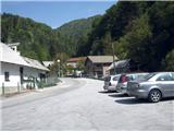
From the Ljubljana - Jesenice highway take the Lipce exit, where we drive right towards Jesenice. In the settlement Slovenski Javornik at the intersection with traffic lights we turn left towards the center of the town. At the second traffic-light intersection (at the high school) we drive right back towards Tomšičeva cesta past the primary school on the left. Behind the school we pass the pedestrian crossing and immediately turn into the first (narrower) street on the left. When we ascend it for some 10 meters, on the right we see the marked parking lot - our starting point.
Route description:
From the parking lot, we continue on the road uphill, whereupon after some 10 meters on the left we notice the summer swimming pool Ukova, and on the right the road which branches off uphill towards the north into the forest.
We step onto the latter and follow it for a short time, i.e. to the right turn before which on the same side there is a fenced water intake. On the other - left side we step onto the path which cuts the double turn of the road we left. Here we also encounter the first blazes. Quite quickly we cross the road again, and step onto the path which begins to ascend towards the north. When it turns left, it joins the cart track beside which we notice a signpost. We do not follow it, but merely cross the cart track and thus step onto the track which ascends initially in the west direction. On the trees we notice the blazes and follow them along the stony, winding, dry, streambed-like track uphill in the NW direction. When after some time we encounter a junction, we choose left and continue uphill following the blazes. Further on we walk the right (main) path, which means we ignore the left turn-offs. When now the narrower, streambed-like path joins a slightly wider track from the left, we continue right. Soon we come close to the stream, or into the area of its gorge. Here on the rocks we encounter a few brackets and pegs, which however do not increase the difficulty of our path at all. Then on the left we notice a small cottage, the path from here onwards crosses the stream several times. When on the left the slope of Mirce disappears, on the same side the forest opens slightly, and here we cross the stream for the last time. In the left - NW direction, the path over stones brings us to a cart track, along which we continue in the same direction to the clearing (Skavarjev rovt) on our right. Here be attentive, because the blazes on this section of the path are quite sparse. First we cross the hardened forest road Prihodi - Križovec and a few meters to the right of the stream on the other side (behind a smaller parking lot) we search for the forest track which in the forest turns right and ascends. After a short time it turns left, and runs in close proximity to the forest road, after which it also discharges onto it. Only some 10 m thereafter, when we have stepped onto the road, at the right bend on the left we notice a small path which ascends into the forest. After some meters it joins a slightly wider path, along which we walk only a few more meters. When on a tree we notice inscribed: "Č.V." (Črni Vrh), we turn left off the path onto an initially less noticeable track, which later changes into an easily followable marked path, which brings us to the forest ridge. Along it we now ascend for quite some time in the NE direction. When we emerge from the forest, we notice a weekend cottage, to which we move aside on the left onto a hunting path and soon branch off from it back to the right onto the forest ridge. Quite quickly we are out of the forest, where along the edge of the meadow we ascend some more 10 m past the linden tree onto the open meadow. In the distance we notice a house which stands near the ski lodge Črni Vrh. We look for the cart track path across the meadow, which past the mentioned house on the right brings us near the chairlift. Here we direct ourselves right, and after some minutes of walking we arrive at the ski lodge. We continue past the lodge in the direction along the chairlift on the cart track. When it forks, we choose right and soon thereafter also left. The cart track after a short ascent leads gently past some weekend cottages, after which it ascends briefly again. At the top of this ascent, where the cart track turns left and levels out, on the left we notice a tree with inscriptions: "Španov Vrh, Zaželjena smer". We thus direct ourselves left onto the small path which takes us above the cottages uphill. After a short time the path levels out, and after some 10 meters of walking we notice the summit of Španov Vrh with the upper chairlift station. Only a few minutes' ascent in the visible direction to the goal follows.

Photos:
 1
1 2
2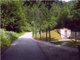 3
3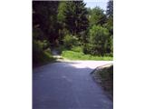 4
4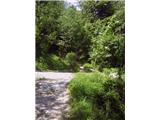 5
5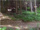 6
6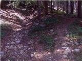 7
7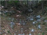 8
8 9
9 10
10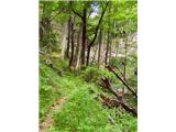 11
11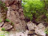 12
12 13
13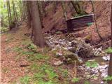 14
14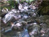 15
15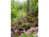 16
16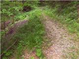 17
17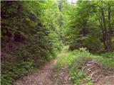 18
18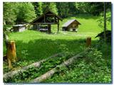 19
19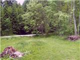 20
20 21
21 22
22 23
23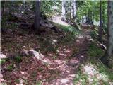 24
24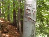 25
25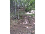 26
26 27
27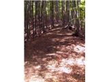 28
28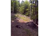 29
29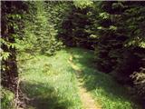 30
30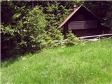 31
31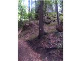 32
32 33
33 34
34 35
35 36
36 37
37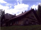 38
38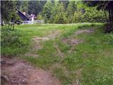 39
39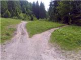 40
40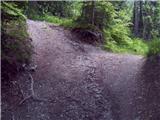 41
41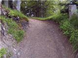 42
42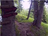 43
43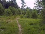 44
44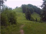 45
45 46
46
Discussion about the trip Jesenice (Ukova) - Španov vrh (Čez sedem grabnov)
|
| Majdag9. 06. 2010 |
They say you cross the ravine 7 times. And it holds true. I went 3 years ago, and there was a lot of fallen trees. Well described path, cheers!
|
|
|
|
| heinz9. 06. 2010 |
Yes, on the 11th picture you can see fallen trees, but no passability issues (cleared). Although forest path, the continuation from Skavarjev rovt onwards is quite nice, - especially towards the top.
Apparently it was the only path to Španov (and/or Črni) vrh years ago.
Lp heinz!
|
|
|
|
| Majdag10. 07. 2010 |
Hi-
Today I went with my dog through the seven gullies. Unfortunately I didn't have your super description with me. So I didn't know which path to take to go through Črni vrh. And the other one. Otherwise the path seems wild to me, overgrown, somewhat tedious. For those who like peace and quiet and aren't bothered by the sound of water. Personally I prefer Mežakla, cheers!
|
|
|
|
| heinz11. 07. 2010 |
Yes, people are different. I liked exactly that: not meeting anyone, very close to civilization yet far away at the same time.
At the Č.V. the path continues almost straight through the forest road (just a bit to the right). It first takes you near a road that branches left from the main one, then along the Špajka ridge to below Črni vrh (ski hut).
Mežakla was also very much to my liking because of its wilderness or peace.
|
|
|
|
| o_O28. 07. 2010 |
heinz, can you describe more precisely where those waterfalls are, I went through 7 grabnov and saw nothing, didn't hear either?
Also, where does the path via Mirca branch off, which joins the scenic path? There are some cart tracks there (above the meadow), but I don't know the exact branch.
thanks,
o_O
|
|
|
|
| heinz28. 07. 2010 |
Yes, that most beautiful waterfall on the right Ukova, where the "čez sedem grabnov" path runs, is located below the edge of the wide gully through which the stream flows, and that's already soon after the marked path crosses the cart track..i.e. after about 10 min of walking. To not miss it, we have to go a bit aside, to the right, along the narrower trodden unmarked path along the edge of the gully - away from the cart-track-like marked stony path that runs a bit more in the middle of the forest. The descent to the waterfall is quite steep and even a bit demanding, so I suggest caution. Otherwise, you can also reach it along the stream bed itself, if the water is not too high. So at the little bridge, head to the left stream bed (first little bridge) of the stream and walk up it for a while to the waterfall.
Here it's actually the right or main tributary - the Ukove branch.
Along the left branch of Ukove (second little bridge), you walk about 1/2 hour along the path towards Jeseniški rovt, then at the spot before a large rock you can hear and of course see the waterfall, and the descent to it is much easier than the previously mentioned one.
The size or impressiveness of both naturally depends on the amount of rain in the previous days due to their torrent nature.
To the Razgledna pot from the čez sedem grabnov path, you get there if on the return at the old collapsed bridge (map), or at the junction from photo 10, instead of left you go straight ahead. The path from there on is of course unmarked - forest cart track, which later, when walking on the southern slope of Mirce, narrows into a trail. At this time it is probably quite overgrown and therefore harder to follow.
You walk along it for quite a long time; definitely more than expected. You step onto the Razgledna pot near Murova.
LP heinz!
|
|
|
|
| heinz29. 07. 2010 |
Correction: On the return for the direction towards Razgledna pot, you don't need to descend near the mentioned old collapsed bridge, because the junction from photo 10 is higher up (closer to the gorge).
You only come across the mentioned former bridge if at the junction from photo 9 on the ascent you continue right - i.e. - if you leave the marked "čez sedem grabnov" path. This path on the other side of the stream turns right and brings us near the bed of the left Ukove, where before the old water intake there is the previously mentioned somewhat smaller waterfall.
|
|
|
|
| Majdag5. 06. 2011 |
...Sedem grabnov, Črni vrh, Španov vrh...
Where to go with such a bad weather forecast? The group didn't go anywhere. Staying home? No way, even if a shower catches me. Iro on the leash, and off we go towards Jelenkamen. But already before the first bridge I change my mind, yes, through Sedem grabnov, on the newly marked path. Pleasant path that at the Ukova stream bed turns sharply left. Soon you're at the rock with pegs. The new bridge wasn't usable today, wet, too narrow. Then a lot of newly sawn trees follow. Well, it goes, even through them, if there's will. At S. rovt I ask a gentleman for the way to Č. vrh. No big problems. After crossing some private property with locked fences at both ends, we find ourselves right in front of the ski hut in Črni vrh. Since we're already there, we go to Španov vrh too. Back to the valley on the other side. Through Lenčkov rovt, to planina Dole and through Jelenkamen back home. Dirty, as expected, but happy. Clothes can be washed, but satisfaction remains, best regards ...Majda
|
|
|
|
| Majdag30. 07. 2011 |
...Seven ravines...the path is cleared, fallen trees sawn up. Silence, you only hear the gurgling of water in the pools. I like our wilderness more and more, and it's so close, čav
|
|
|
|
| Toni-k29. 09. 2011 |
Hello everyone, first of all, especially Heinz, who seems to have the Jesenice paths at his fingertips. I've visited hribi.net several times to find some path or connection to the valley. Namely, I deal with mountain biking. Yesterday I descended via Jeseniški rovti to Ukova. The path is interesting, rideable, but I didn't dare step on any of the bridges, especially with the bike on my shoulder. At the junction a bit below the spring, I took the right path, crossed or climbed over the rocks across Ukova and reached the cart track, which a bit further meets the cart track coming from 7 grabnov. I chose this path precisely because of the description given by Heinz. But I have a question for those who know Mirca, namely today I descended from Skavarjev rovt to Prihodi, at Zgornji Prihodi I found a forest road that runs eastwards quite far. I went to the end of this road and looked for some path or cart track to descend to the valley. In the middle somewhere I found an overgrown cart track that was descending but I didn't want to go blindly. Does anyone know where it leads? What's its condition?
Thanks for answers and best regards
Toni-k
|
|
|
|
| heinz30. 09. 2011 |
As far as Mirca is concerned, on its right side viewed from behind (left 7 grabnov) there is also a good path to the valley, which was even marked in its time. It takes you to Zgornje Pejce. From there you can continue right downhill towards the road to rovte, or left on the macadam into the forest to the rdeče skale (former red marble quarry), near which you turn right off the path, downhill through the forest slope. A bit lower you hit a path that takes you to Razgledna cesta a bit above Murova.
Probably there is also some old connection or forest path between Prihodi and Pejce. As for Mirca itself, there are these two (for going down): on the eastern and western slope. To the summit itself (1025) there are three.
|
|
|
|
| Toni-k30. 09. 2011 |
Yeah, yesterday I cycled that macadam to the end, on the way back I noticed an overgrown track down into the valley a bit before the red rocks. Need to try that, from there onwards towards Pejce under the rocks themselves I noticed some stone wall and from there on the slope under the road is littered with rocks and quite steep. That path to the right near Skavarjev rovt to Pejce I've ridden a few times, was interested in further on, even though recently I found a path past Pejce, by the chapel at Murovo.
|
|
|
|
| heinz30. 09. 2011 |
Yes, there under the red rocks is really an old wall.. If you go along that road off GG-ja, which you say you cycled to its end yesterday, then also there, if you descend a bit, you can stumble upon a path that crosses this southern slope of Mirce from the east and descends west to Razgledna cesta. That's the path >čez Pekovo planco<, which comes from the 7th grabnov. Before the rocks I too have noticed some old path down (near the stream), but I haven't tried it. Those by the chapel at Murovo I don't know. (not everything fits in my little finger..)
|
|
|
|
| panda1016. 04. 2014 |
Hi!
has anyone been through the seven ravines to Španov vrh in the last days? how is it with fallen trees after the ice storm? Is the path passable at all??
|
|
|
|
| Majdag9. 05. 2019 |
7.5...On foot from home, but not through the gullies, through Pejca I went. Snow is already on Skavarjev rovtu. With altitude it gets more. The ridge of Š.V is thickly covered with snow. In places it's windblown and the ground is frozen in the morning. I saw very few daffodils, only before the black peak under the melted snow. Views from the top are beautiful, nice wandering.
https://jelenkamenmajdag.blogspot.com/2019/05/pomladno-zimsko-potepanje.html
|
|
|
|
| zlatica11. 05. 2019 |
Majda, you had a real journey, from green areas, snowy ridges, to beautiful daffodils, stunning mountain views, in short super diverse hill walking. And how well you identified the mountain peaks! I really admire you for knowing all this mountain beauty so well or being able to identify it. That's why I always like reading your stories and leaning on the beautiful photos.
|
|
|
|
| Majdag12. 05. 2019 |
Zlatica, thanks, those areas I still know somehow, but not the Bohinj ones, Ločanka describes them best and some others..
|
|
|
|
| Jusk15. 02. 2020 |
Since Ukova currently has very little water it sinks somewhere in the middle of the 7 gullies, so the lower part of the gully is completely dry. Stream crossing without problems..from Črni vrh towards Španov vrh the trail is very icy, caution! For a good loop trail I recommend return to Pristava and via Gajškova trail. Regards
|
|
|
|
| Jusk8. 11. 2020 |
After returning with the group from Jelenkamen, I decided to jump up here too; there was enough time until the return to the start I went from Murova via Rudni poti past Zg.Pejc; from Skavarjev rovta via this described path. At the top I catch the last rays of today's sun the path towards the top of Španov vrh is very muddy; in shady spots snow was still holding even at 4 pm.. but also nice views all around
|
|
|
|
| Jusk28. 11. 2020 |
today via 7grabnih to Španovga, along the graben it's nicely passable, little water.. further from Skavarjev rovt along unmarked paths and planinas around there.. Španov vrh is no longer muddy as some time ago, all frozen. Back to Ukove via Lenčkov špik and Dole, the whole path without peculiarities and normally passable. Lp
|
|
|
To post a comment you must log in:
If you do not yet have a username, you must first
register.