Starting point: Jezerski vrh (1218 m)
| Latitude/Longitude: | 46,41880°N 14,52680°E |
| |
Walking time: 3 h 30 min
Difficulty: easy unmarked way
Elevation gain: 583 m
Elevation difference along the route: 810 m
Map: Karavanke - osrednji del 1:50.000
Recommended equipment (summer):
Recommended equipment (winter): ice axe, crampons
Views: 2.590
 | 1 person like this post |
Access to starting point:
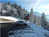
First, we drive to Preddvor or to the settlement Tupaliče (to here from the Gorenjska motorway or Kranj), and then we continue driving in the direction of Jezersko and further towards Austria. When we get to the border crossing Jezersko, we park on the parking lot on the Slovenian side (also possible on the Austrian side).
Route description:
From the parking lot on the Slovenian side of the border we continue towards Austria, and then still on the Slovenian side we turn left onto the first road that branches off from the main one. After a few steps of walking on the mentioned road we notice yellow hiking signposts, which direct us towards Pristovski Storžič / Kärtner Storschitz, and we bypass the signs on the left side and continue further on the macadam road. The road a little further turns slightly to the left and passes entirely onto the Slovenian side, where it ascends transversely along the slopes of Pristovski Storžič. Further on, the road takes us to the upper edge of the mountain pasture Rakeževa planina, from which a nice view opens up onto Zgornje Jezersko and the highest peaks of the Kamnik-Savinja Alps. The road continues through the forest, occasionally leading us also over some panoramic section. Higher up, at the former JLA guard post, a path past Anko's waterfalls joins from the left, and we continue along the road, which levels out completely. A little further, at a smaller crossroads we continue on the left road (via the right road we can reach Pristovski Storžič (the road after crossing joins the marked path from the village Korte / Trögern)), which then gradually begins to descend more noticeably. After a few minutes of descent we arrive at Roblekova planina, from which a nice view opens up onto Virnikov Grintovec, Pečovnik, Plešivec and Tolsta Košuta.
From the upper part we descend to the shepherd's hut, which we bypass on the left side. Lower down the road enters the forest and brings us to a marked junction, where to the left branches off the marked path to Virnikov Grintovec / Kleiner Grintoutz, and we continue further along the road, which descends moderately. A little lower still the road turns right, so that it runs parallel to Grintoviški potok / Grintoutzbach, which is on our left side. From the bend we walk a few more steps along the road, then via easier pathless terrain we descend to the stream, cross it carefully, then on its other side we begin to ascend moderately towards the west, where with a bit of luck we quickly step onto a cart track that after 2 to 3 minutes brings us to another macadam road, which we reach right at the right hairpin bend (viewed in the direction of ascent along the road).
We ascend over the hairpin bend and continue the ascent along the moderately rising road, which quickly brings us to a sort of ridge, where to the left a cart track branches off, initially still a road, which ends below the slopes of Virnikov Grintovec, and we continue slightly left along the wider macadam road. There follows a traverse of mostly the northern slopes of Virnikov Grintovec, where along part of the path a nice view opens up onto the wall of the mentioned peak, and on the other side we can clearly see Obir. There follows a somewhat longer descent, but from the road nice views still open up towards Tolsta Košuta, Obir, Pristovski Storžič and the other surrounding mountains. At a few smaller crossroads we continue along the "main" road, which runs mostly west to northwest, all the time along the Austrian side of the state border. When the road starts ascending again it gradually approaches the state border completely, a little higher up the road makes a sharp left bend. After the mentioned hairpin bend the road returns again to the state border, and we follow it almost to its end. It is best to leave the road somewhere near the border stone No. 222 (a few border stones are visible from the road, so we can approximately foresee which is the stone No. 222), then continue along a narrow path that runs directly along the state border. When we leave the road we first ascend moderately, then we emerge from the forest along the edge of a larger clearing. Across the clearing we ascend along the Slovenian side of the state border in a gentle ascent. When the ascent ends, a few steps of descent follow. After these few steps of descent we join a better-trodden path that leads from the ruins of Pečovnik (former JLA guard post).
We continue along the better-trodden path, which continues along the Slovenian side, and after a few minutes of traversing ascent it returns to the ridge. We continue slightly left and pass by the stone No. 238 below the summit of Pečovnik (1640 m), which is just a few steps from the path.
We continue straight ahead, where the path further leads along the edge of a larger border clearing. After a few minutes of walking, where the path runs almost without elevation changes, we slowly begin to ascend moderately towards the next summit (Pečovnik - elevation 1668), which we reach without major difficulties and from which a view opens up reaching all the way to Triglav.
From the mentioned summit we continue in the same direction as before, before we begin to ascend towards Plešivec a short descent still separates us, which we cover amid nice views onto Plešivec and Košuta. When the path, continuing along the border ridge, rises slightly, a view back opens up onto the Kamnik and Savinja Alps. When the wider strip of old clearing ends, the path brings us to an initially somewhat vegetated ridge, then ascends over a short steep step (undemanding). Higher up the increasingly sparse spruce forest is replaced by a fairly dense belt of dwarf pines, where the path is harder to follow in some places, as the dwarf pines have overgrown considerably. Once we push through the belt of dwarf pines with a little difficulty, the path becomes clearly visible again, and we quickly ascend along it to the panoramic summit.
The description and photos refer to the conditions in 2015 (November).

Photos:
 1
1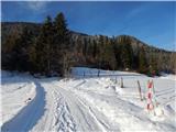 2
2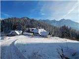 3
3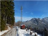 4
4 5
5 6
6 7
7 8
8 9
9 10
10 11
11 12
12 13
13 14
14 15
15 16
16 17
17 18
18 19
19 20
20 21
21 22
22 23
23 24
24 25
25 26
26 27
27 28
28 29
29 30
30 31
31 32
32 33
33 34
34 35
35 36
36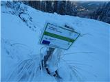 37
37 38
38 39
39 40
40 41
41 42
42 43
43 44
44 45
45 46
46 47
47 48
48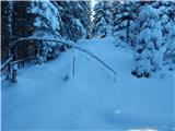 49
49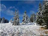 50
50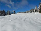 51
51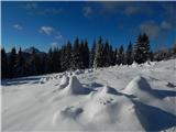 52
52 53
53 54
54 55
55 56
56 57
57 58
58 59
59 60
60 61
61 62
62 63
63 64
64 65
65 66
66 67
67 68
68 69
69 70
70 71
71 72
72 73
73 74
74 75
75 76
76 77
77 78
78 79
79 80
80 81
81 82
82 83
83 84
84 85
85 86
86 87
87 88
88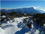 89
89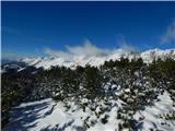 90
90
Discussion about the trip Jezerski vrh - Plešivec
To post a comment you must log in:
If you do not yet have a username, you must first
register.