Jurišče - Bele stene (eastern way)
Starting point: Jurišče (704 m)
| Latitude/Longitude: | 45,66420°N 14,29500°E |
| |
Route name: eastern way
Walking time: 1 h
Difficulty: easy marked way
Elevation gain: 159 m
Elevation difference along the route: 159 m
Map: Snežnik 1:50.000
Recommended equipment (summer):
Recommended equipment (winter):
Views: 9.298
 | 3 people like this post |
Access to starting point:
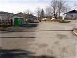
From the highway Ljubljana - Koper, we take the exit Postojna and follow the road ahead in the direction of Pivka. In the settlement Pivka, we leave the main road which runs towards Ilirska Bistrica and continue driving towards Knežak. We follow this road to the village Parje, where we turn left in the direction of the villages Palčje and Jurišče. On the mostly slightly ascending road, we then follow to the village Jurišče, where we park nearby the information board.
Route description:
From the parking lot, we continue past a smaller memorial park along the road in the direction of Kršičevec. The road, which soon loses its asphalt surface, quickly brings us to a smaller intersection, where we continue on the left lower road (next to the right road there is a smaller cross), which continues along the left side of the fence. Only a little further, we arrive at a well-marked junction, where the path towards Bele stene and Spodmol branches off to the left (straight to Kršičevec).
We continue in the direction of Bele stene along a cart track which crosses extensive grassy slopes. Further on, we cross a smaller macadam road and only a little later we step onto another wider macadam road, which we follow to the right. We follow the mentioned road only a few steps, because soon the blazes direct us to the left onto a cart track, which first ascends parallel to the road, then passes by the foot of the mountain Jerusi, on which Bele stene and Spodmol are located.
After a few minutes of further walking, the blazes direct us a little more to the left onto a quite overgrown footpath, which starts to ascend through dense forest. Higher up, we reach a smaller clearing along which the path continues steeply upwards. At the top of this ascent, we step onto an abandoned cart track, which we follow in a gentle descent to the right. Only a little further, the blazes direct us sharply to the left onto a path, which again starts to ascend more steeply and quickly brings us to Spodmol. A few meters further, we also reach the eponymous cave, then we continue the ascent along a relatively gentle path, which after a few minutes of further walking brings us to the Bele stene viewpoint.

Along the route: Spodmol (825m)
Photos:
 1
1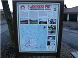 2
2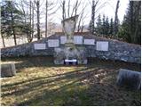 3
3 4
4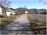 5
5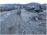 6
6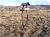 7
7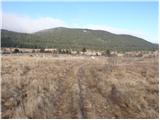 8
8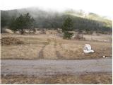 9
9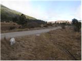 10
10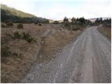 11
11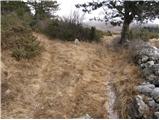 12
12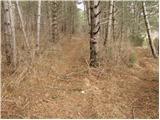 13
13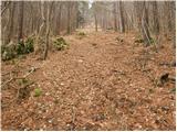 14
14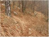 15
15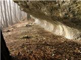 16
16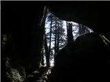 17
17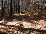 18
18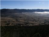 19
19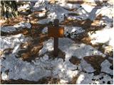 20
20
Discussion about the trip Jurišče - Bele stene (eastern way)
|
| Tadej27. 01. 2009 |
If you have visited Kršičevec and have some time left, it's worth making a short detour and climbing to Bele stene as well.
|
|
|
|
| gdbl23. 02. 2009 |
Nice family trip. We enjoyed the solitude. The original plan was to climb to Kršičevec, but due to the wind we preferred to turn to Bele stene, as the path mostly goes through the forest.
Bojan
|
|
|
|
| lidijah27. 12. 2015 |
We were there on Sunday, the trip would be nice, but the hiking trail is impassable due to fallen trees, when the trail turns into the forest there are no markers until near the top, we didn't see the caves and overhang, the trail is supposed to be circular but the markers are lost even at the top, on the way back to the village we were followed by 2 large dogs from the nearby farm, which wasn't pleasant at all, apparently the locals in Juršče let their dogs roam free!!!
|
|
|
|
| acti6. 04. 2020 |
Yesterday solitary walk to Bele stene. Trail excellently marked: ascent via eastern, return via western trail. Good side of corona: we discover unknown trails in our municipalities...
|
|
|
|
| bizgo9324. 02. 2021 |
Yesterday my partner and I were on Bele stene for the first time. I recommend the circular route up the eastern path and down the western one. When the path transitions from the meadow to the forest, it is partially overgrown in some places (nothing too bad), but excellently marked. Highlights along the path include the wonderful pine forest, karst overhang and cave of the same name, and the summit itself with a nice view of the Juršče valley, Kršičevec and surrounding hills and Snežnik. The summit also has a stamp and summit register box.
|
|
|
To post a comment you must log in:
If you do not yet have a username, you must first
register.