Starting point: Kamna Gora (700 m)
| Latitude/Longitude: | 46,32380°N 15,37850°E |
| |
Walking time: 1 h
Difficulty: easy marked way
Elevation gain: 312 m
Elevation difference along the route: 350 m
Map:
Recommended equipment (summer):
Recommended equipment (winter):
Views: 19.210
 | 1 person like this post |
Access to starting point:
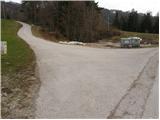
From the highway Ljubljana - Maribor we take the Celje exit and we follow the road ahead towards Vojnik. From Vojnik we continue on the main road towards Slovenske Konjice, but only to the spot where the road branches off to the right towards the village Črešnjice. We follow this road through the mentioned village to the village Sojek, where we continue left upwards towards Kamna gora. When we notice signs for Stolpnik 1 hour, we park on the parking lot near a smaller crossroads.
Route description:
From the parking lot, we continue on the road in the direction of Stolpnik. After a short ascent, the asphalt ends and we continue on a worse road which goes into the forest. In the forest the blazes guide us to the left onto a footpath which at the beginning crosses a worse road quite a few times. After a few minutes, we again step on a worse road which at the water supply building finally changes into a cart track. The cart track which at first ascends quickly brings us to a small saddle, from which the path starts slightly descending. A little further, the path brings us to the forest road which we follow to the right, but only to the next crossroads. Here, where we notice numerous signposts, we continue left in the direction of Stolpnik. A wide moderately steep path leads us further through the forest, where we cross a smaller partly already overgrown clearing. After the clearing, the path for a short time entirely flattens, and then in a moderate ascent brings us to the summit, where a lookout tower stands.

The trip can be extended to the following destinations: Stolpnik
Photos:
 1
1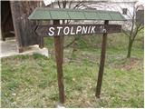 2
2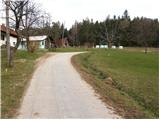 3
3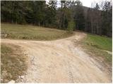 4
4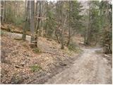 5
5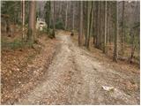 6
6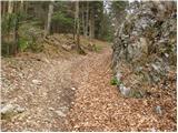 7
7 8
8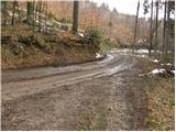 9
9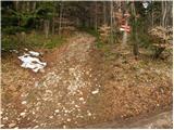 10
10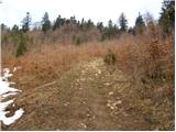 11
11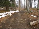 12
12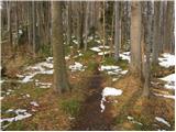 13
13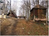 14
14 15
15
Discussion about the trip Kamna Gora - Stolpnik
|
| katja875. 03. 2012 |
On Sunday we headed to Stolpnik (1012 m), which has a 25 m high observation tower on the summit.
We started the path from Slovenske Konjice, first to Skala via a very demanding marked path. So we conquered Skala summit (750 m) via a really nice and very well secured "small and short ferrata", which is really an adrenaline rush
We did a circular route: Slovenske Konjice - Skala (via steep path) - Stolpnik (via Kamna gora) - Slovenske Konjice (via Grofov štant).
For the entire circular tour we took good 4 hours. Weather was sunny, almost no snow.
As the weather was warm and sunny, we ended up driving to Trojane and from there also to Čemšeniška planina (1204 m).
You can view the photos on the website of Planinsko društvo Matica Murska Sobota: http://www.mojalbum.com/pdmaticams/20120304-konjiska-g-cemseniska-pl/foto/19483835
|
|
|
|
| brinta6. 03. 2012 |
I'm wondering if the path from Vrh Skale to Stolpnik is marked?
|
|
|
|
| katja876. 03. 2012 |
Right from the top of Skala there is no signpost to Stolpnik, but only to Kartuzija.
Therefore, if you want to head from Skala to Stolpnik, you must not go towards Kartuzija (left path), but descend from the top along the right path (towards Slovenske Konjice). Then you reach a junction (forest road), where there is another signpost to Kartuzija and at that sign you head in the indicated direction. However, when you cross the forest path, you reach an asphalt road, where there is also the Treh križev junction. There the first signpost to Stolpnik appears.
When heading towards Stolpnik, you soon reach another junction, where you have the option to go to Stolpnik via two different paths. One is via Skalna gora (half the path on asphalt through Skalna gora village, half through forest) or via Grofov štant (entire path through forest).
We did a circular tour at that point, namely to Stolpnik summit via Skalna gora, descent via Grofov štant. But the path via Grofov štant is much nicer, as it avoids walking on asphalt through the village.
p.s.: I hope the instructions are fairly understandable, but I couldn't explain it shorter 
Happy trails if you decide for this tour 
|
|
|
|
| aonuk17. 03. 2012 |
Nice that you're looking for various variants around our parts (Konjiški gori). It is really hard to describe the paths, because there are many trails, roads and rail. Well-intentioned, but the village (skalna gora) mentioned three times we don't have, it's Kamna gora. No hard feelings, safe steps... best regards Vinko
|
|
|
|
| pohodnica537. 03. 2012 |
@ brinta: if I may add - you have to be quite careful around the markings; we from Skalce continued towards Kartuzija (meant Stolpnik) and then additionally missed the marking (misled by extensive logging); we went a bit on our own, extended variant and nevertheless arrived at Stolpnik in the end; otherwise very nice, circular tour - recommend; best regards
|
|
|
|
| katja877. 03. 2012 |
Yes, such a tour is fine too - it just extends it a bit
It is true that you have to regularly follow markings and signposts, as there are tons of paths and you can quickly stray from the right one. There are also plenty of unmarked paths made by locals, so you really have to watch out.
P.S.: I apologize for constantly writing Skalna gora in the previous post, in reality it's Kamna gora ... I don't know what got into me
|
|
|
|
| brinta8. 03. 2012 |
Thanks for the information, hope I succeed!
|
|
|
|
| bruny1. 05. 2012 |
On Tuesday 01.05.2012 a wider hiking circular connection also along part of the described route above and that from the settlement Sojek through the wider hinterland of Žička kartuzija on the east between Špitalič and on the west - Vojnik on the route Špitalič - Žička kartuzija - Sv. Tomaž - Vojnik - Kladnart - Brdce - Sojek - Kamna gora - Stolpnik - Skala - Žička kartuzija - Špitalič.
Route:Stolpnik all round/Špitalič - Vojnik, 01.05.2012
Nice tour with colleague Vinkot from PD Poljčane and again new insights into an even somewhat wider space, which is actually most characterized by Žička kartuzija... Garmin emptied in the area of Skala. Together about 40 kilometers and 2000 elevation meters on dry paths but it was also quite hot. I anticipate a return in a somewhat even more concrete loop and even wider view into the world of Konjiška gora...
|
|
|
|
| tuna.iris31. 10. 2014 |
For a good morning to Stolpnik via this path. Pleasant, non-strenuous and well-marked path, just right for a quick trip to the hill.
|
|
|
|
| tuna.iris29. 11. 2014 |
On this gloomy day to Stolpnik, even fog has its charm.
|
|
|
|
| tuna.iris11. 04. 2015 |
Wonderful day for a hike to Stolpnik surrounded by fog.
|
|
|
To post a comment you must log in:
If you do not yet have a username, you must first
register.