Klemenčevo - Kamniški vrh (by Korošaki waterfalls)
Starting point: Klemenčevo (600 m)
| Latitude/Longitude: | 46,27390°N 14,57090°E |
| |
Route name: by Korošaki waterfalls
Walking time: 2 h 15 min
Difficulty: easy unmarked way
Elevation gain: 659 m
Elevation difference along the route: 700 m
Map: Kamniške in Savinjske Alpe 1:50.000
Recommended equipment (summer):
Recommended equipment (winter): ice axe, crampons
Views: 54.024
 | 2 people like this post |
Access to starting point:
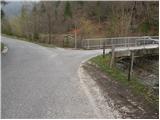
From Kamnik we drive towards Stahovica. Immediately after the village Godič we turn left on the road in the direction of Županje njive. At the next crossroad, we go left in the direction of Bistričica and we follow the road to the village Klemenčevo, where we turn right over a small bridge and then we park on a smaller parking lot. In front of the bridge are signposts for Kamniški vrh and mountain pasture Osredek.
Route description:
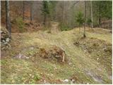
From the parking lot, we continue on the main road which gently ascends on the left side of the stream (right bank). After a few minutes of walking, the path brings us to a bus turnaround, after which we notice the mountain signposts for Ambrož pod Krvavcem. Only a little further the road brings us to a smaller intersection, where we continue right over a bridge. After the bridge, we reach houses, at which we leave the marked path towards Krvavec. We continue right on a cart track which ascends across a meadow. The cart track, becoming worse the higher we go, leads us between two hayracks and then to a smaller stream confluence at the ruins of an old house. The path ahead leads on the right side of the ruins and then over a wire fence to the stream along which we then ascend. The path, which further runs along the stream, crosses it several times. At the spot where the path withdraws from the gorge to the right, we notice the 1st waterfall to which we have only a minute of walking along the streambed. At low water level, it does not deserve the name of the 1st waterfall.
The path which withdraws from the gorge to the right brings us after a short ascent to the next waterfall, which in dry periods completely dries up. The path, which further ascends more steeply, quickly brings us to a smaller saddle, where we reach the next junction. To the left, first slightly downhill then uphill, the path branches off to the next waterfall. After five minutes of walking we reach the lower one in the main chain of waterfalls. If we want to reach the upper largest one, we must climb steeply uphill along the left side of the waterfall (not suitable for less experienced).
From the waterfalls we return to the junction and continue on the path which further steeply ascends on an increasingly less vegetated slope. The steep path further crosses some slightly exposed slopes which in wet conditions are dangerous for slipping. The increasingly scenic path then brings us to a cross, at which we join the marked path. We continue left on the gentle path which brings us to the mountain pasture Osredek in 5 minutes of further walking.
From the mountain pasture we continue right in the direction of Kamniški vrh on the path which in a moderate ascent through the forest brings us to the next junction, where we turn right (left to Krvavec). We continue along the northern slopes through the forest. After more than 30 minutes from the mountain pasture, the path brings us to the saddle between Planjava and Kamniški vrh. Here a view opens towards the south. We continue left along the ridge path along which we reach the summit in a few minutes.

Photos:
 1
1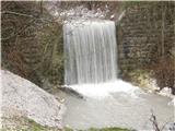 2
2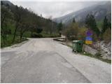 3
3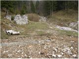 4
4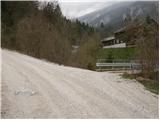 5
5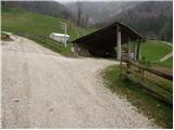 6
6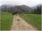 7
78
 9
9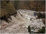 10
10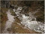 11
11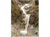 12
12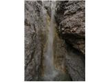 13
13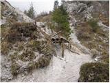 14
14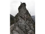 15
15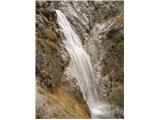 16
16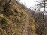 17
17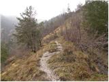 18
18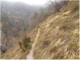 19
19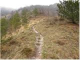 20
20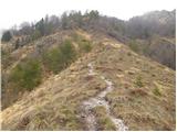 21
21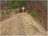 22
22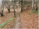 23
23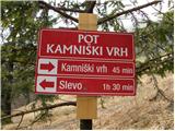 24
24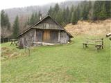 25
25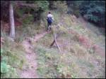 26
26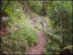 27
27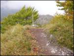 28
28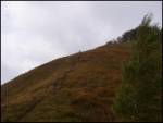 29
29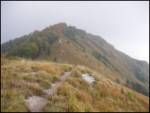 30
30 31
31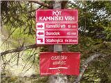 32
32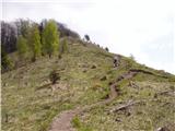 33
33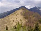 34
34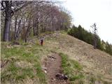 35
35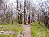 36
36 37
37
Discussion about the trip Klemenčevo - Kamniški vrh (by Korošaki waterfalls)
|
| Kokta26. 05. 2012 |
Yes, the lower part is unmarked, so I came out somewhere on the path over Slevo. I found the waterfalls only on the way back when I turned right down before Slevo on an unmarked path and then climbed up again over the scree.
It's worth exploring a bit on these unmarked paths. Nice hike, and the weather held up 
|
|
|
|
| LidijaJesih21. 09. 2014 |
When they are grazing (at least then) the start is a bit different. At the car visible in picture 3, turn right onto the cart track, then twice across the stream and up the cart track. When the first path, which is also a bit wider, branches off to the left from the cart track, the path descends to the water after a few minutes, which you cross again. And you are just behind the fence from picture 9. Or according to the above description, but you have to go through the electric fence and past cows (bulls?), I don't know if the residents above are thrilled about it. The path is not visible.
|
|
|
|
| navdušena6. 05. 2018 |
I more highly recommend the start described by LidijaJesih. Drive past the bus turning area for the car, from there at the sign into the forest is a cart track... as described in the comment. Better than walking across the meadow, especially if the grass is already high - the farmer won't be pleased. I recommend the return - descent from the saddle directly down, when we reach the plain, keep to the right, at the direction signs (before Slevo) turn right onto the path, cross the fence a few times - there are gates or arranged passages - and we reach the path described for the start.
|
|
|
|
| darkom25. 04. 2021 21:20:52 |
On 24/04/21 I walked the mentioned path (at the beginning at the sign turned right onto the cart track).
The path is without peculiarities and normally passable.
|
|
|
|
| plaNinaPirsMajcen20. 01. 2025 20:42:07 |
https://youtu.be/vFUbTvP8-V0?si=-B8HTcdkp6f8-8Uz
I'm attaching a video from yesterday's hike. My friend and I recorded the trail as detailed as possible; in the first part of the gorge, it's quite damaged and harder to follow. It's wild, peaceful, and beautiful.
We started a bit lower, as previous reports describe. The sign Kamniški vrh | slapovi directs us from the parking lot to the right across the stream, which we cross once more shortly after. After a few minutes, we branch off to the left from the main path (I show in the video) and reach the gorge. The path ahead needs a bit of searching, it's visible, then it fades a bit. When we reach the characteristic pointed stone tower, there's immediately a junction above it, where you go left down to the waterfalls, but we ascend to the right. In the continuation, a nicely visible path takes us higher up to the cross, where before planina Osredek we step onto the marked trail.
My friend and I returned via the marked trail towards planina Osredek to the settlement Slevo. In the last part of the trail, we turned towards Klemenčevo.
Best, Nina
|
|
|
To post a comment you must log in:
If you do not yet have a username, you must first
register.