Koča na Gozdu - Visoki Mavrinc
Starting point: Koča na Gozdu (1226 m)
| Latitude/Longitude: | 46,43990°N 13,76240°E |
| |
Walking time: 1 h 15 min
Difficulty: easy unmarked way
Elevation gain: 336 m
Elevation difference along the route: 350 m
Map: Kranjska Gora 1:30.000
Recommended equipment (summer):
Recommended equipment (winter): ice axe, crampons
Views: 93.833
 | 2 people like this post |
Access to starting point:
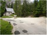
From Kranjska Gora, we drive towards the mountain pass Vršič, but only to the mountain hut Koča na Gozdu, near which we park on a large parking lot.
Route description:
From the mountain hut Koča na Gozdu on Vršič road we descend a few 100 m to a marked junction, where we notice mountain signposts for Erjavčeva koča na Vršiču. We head onto the mentioned path, which we follow only a few 10 steps. After a few steps of ascent we arrive at an unmarked junction, where we continue right on an unmarked path, which first starts gently, then steeper and steeper ascending towards the north. A relatively easy-to-follow path, along which we notice some marks PP (path Planica - Pokljuka), brings us after approximately 1 hour of walking to a small saddle between Kumlehova glava on the left and Visoki Mavrinc on the right.
We continue right into a dense forest (left Kumlehova glava) on the path which first ascends gently on an indistinct ridge and then turns a little to the right, where it starts ascending steeper. Only another 5 minutes of ascent follow and a more panoramic path quickly brings us to the summit of Visoki Mavrinc.
Photos:
 1
1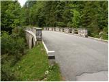 2
2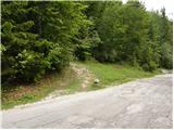 3
3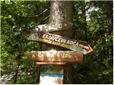 4
4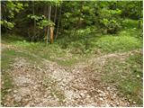 5
5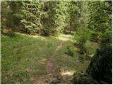 6
6 7
7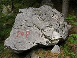 8
8 9
9 10
10 11
11 12
12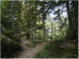 13
13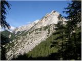 14
14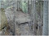 15
15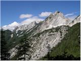 16
16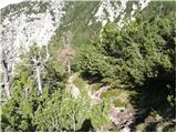 17
17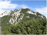 18
18 19
19
Discussion about the trip Koča na Gozdu - Visoki Mavrinc
|
| clo4. 08. 2010 |
is there perhaps a stamp at the top
|
|
|
|
| rober4. 08. 2010 |
Yes...but,when you see what kind of view is offered,you'll forget about the stamp in an instant....
|
|
|
|
| Jože.4. 08. 2010 |
Stamp ,... we don't go just for them. But the path from Koča na Gozdu is so short that it's better to do a circular path from Erika, or. the second bend of the Vršiška cesta, then descent towards the hut on Gozdu. At the saddle before Mavrinc you can also make a jump to Kumlehova glava.Wonderful views. Suitable in all seasons. ( by the way - there is no stamp ; so what )
|
|
|
|
| clo5. 08. 2010 |
I myself don't hike for the stamp. But if you have a six-year-old child who draws and writes in her mountaineering booklet the stamp also means a lot to her, by the way why are stamps needed to obtain young mountaineer badges?
|
|
|
|
| clo5. 08. 2010 |
Thanks Rober for the reply.
|
|
|
|
| lukecpukec24. 04. 2011 |
Yesterday I was at Mavrinc. All I can say is that for many years I've been hiking in the hills and mountains around Kranjska Gora, but such a view as Mavrinc offers, I've never experienced anywhere... the tour is otherwise completely dry. Best regards
|
|
|
|
| viharnik24. 04. 2011 |
If you make the effort to the nearby Kumlehova glava, the view is even more magnificent, even to Visoke ture.
|
|
|
|
| lukecpukec24. 04. 2011 |
Thanks for the suggestion... next time I'll jump over to Kumlehova glava too. Best regards
|
|
|
|
| JusAvgustin24. 04. 2011 |
I suggest the entire ridge, which won't leave you indifferent...  so close to civilization yet so remote you'll feel at the same time so close to civilization yet so remote you'll feel at the same time
Juš
|
|
|
|
| lukecpukec25. 04. 2011 |
And you mean the ridge that runs from Kumlehova glava via Robičje? How much climbing is there?
|
|
|
|
| JusAvgustin25. 04. 2011 |
you start at the škrbinjek, end at the summit. In the book ridges of Slovenian mountains you have a detailed description. definitely without ropes...
|
|
|
|
| lukecpukec26. 04. 2011 |
aha, thanks for the info...best regards
|
|
|
|
| Majdag18. 06. 2011 |
...We always go up in winter when there's still lots of snow. It's nice, everything white. It must be a pleasure in summer too. The path was wet, wind, even rain. But at the top as always calm, no wind. Views were covered by clouds and mists. No problem, it won't be long, next time will be better...Majda
|
|
|
|
| Holcar24. 01. 2013 |
And who knows what the snow conditions are like on Mavrinc, and especially if snow chains are needed to Koča na Gozdu? And would crampons be needed (if yes-which ones?) and gaiters.
|
|
|
|
| Nautillus 5. 01. 2013 |
No snow chains needed for the car, probably no crampons either. Gaiters you can leave at home too.
|
|
|
|
| Holcar25. 01. 2013 |
Well today I experienced it myself, although I missed your (@Nautillus)
post. Just in case I packed small crampons at home in the backpack, which helped me a lot (descent!), as the path is icy in places and especially in the upper part and just below the summit, muddy, trampled and of course steep. I didn't really need gaiters, as there's actually little snow, it lies in patches and rarely reaches over the ankles. The view was wonderfully as forecasted, I advise everyone heading up there not to forget the camera.
|
|
|
|
| Holcar25. 01. 2013 |
But I couldn't find the stamp anywhere, in the box there's only a booklet with a pen.
|
|
|
|
| Skuta1. 11. 2015 |
We also missed the stamp for even greater children's joy ☺
|
|
|
|
| mpirtov30. 07. 2021 17:51:36 |
Magnificent view. We'll come back.
After the mentioned right junction (above in the description) after a few meters there is a left junction. The first is more scree-covered, after a couple of meters another, gentler one, both lead in the right direction.
|
|
|
|
| saqo12. 07. 2022 13:10:58 |
Is the path clearly visible even though it's unmarked? Is there a chance to stray onto a side path?
|
|
|
|
| Majdag12. 07. 2022 19:22:03 |
sago, imagine the ridge straight up. Don't go left or right on paths, but on the most trodden upwards and you'll reach the ridge. On the ridge then right, then on the path to Visoki Mavrinc.Good luck!
|
|
|
|
| turbo12. 07. 2022 21:05:05 |
If you go a little left and right from the most trodden path, you'll pick mushrooms along the way too
|
|
|
|
| Majdag13. 07. 2022 09:00:17 |
bojan mushrooms are hard, but you can stray under the Vovovje scree or somewhere else. The first time is the hardest, then you can relax your own way.
|
|
|
|
| dprapr13. 07. 2022 10:01:01 |
There really are mushrooms growing there (chanterelles, boletus). Verified.
|
|
|
|
| Barbara 7530. 12. 2024 12:04:14 |
Hi, please for info if the road to Koča na Gozdu is clear, thanks
Barbara
|
|
|
|
| aleš k30. 12. 2024 12:25:49 |
Clear.
|
|
|
|
| Barb12316. 01. 2025 14:54:40 |
Maybe someone knows what the conditions are like?
|
|
|
|
| Majdag11. 03. 2025 12:54:11 |
9.3... From Mala Pišnica to the bridge V. Pišnica traffic is directed by a traffic light. Parking at Koča na Gozdu is a skating rink, the road is dry and the bridge is new. The path to Mavrinc is mostly dry, cowbells are just emerging from the cold ground. The last bend is as always icy at this time, brush is under snow. At the top quite some visitors and heavenly views. Paradise for soul and heart. Beautiful on this mountain..
https://jelenkamenmajdag.blogspot.com/2025/03/mavrinc-otocek-sredi-raja.html
|
|
|
|
| Majdag29. 08. 2025 12:09:43 |
27.9. Mavrinc, my most visited mountain, this time with a large group. The hikers from DU Javornik Kor. Bela had the opening of the autumn hikes. So many of them stand on the summit so rarely and admire the peaks all around. The paths are dry, there is still no water at the crossing. Only mists quickly gathered around the peaks. Nice as always.
https://jelenkamenmajdag.blogspot.com/2025/08/z-druzbo-na-visoki-mavrinc.html
|
|
|
|
| bo_zl21. 12. 2025 18:35:01 |
Today quite visited, sunlit summit. The path almost entirely dry, just below the summit some frozen snow and ice, which poses no problems.
|
|
|
To post a comment you must log in:
If you do not yet have a username, you must first
register.