Koča na Pesku - Lake Ribniško jezero (via Lovrenška jezera)
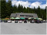
Starting point: Koča na Pesku (1386 m)
| Latitude/Longitude: | 46,46700°N 15,34410°E |
| |
Route name: via Lovrenška jezera
Walking time: 3 h 15 min
Difficulty: easy marked way
Elevation gain: 104 m
Elevation difference along the route: 400 m
Map: Pohorje 1:50.000
Recommended equipment (summer):
Recommended equipment (winter): ice axe, crampons
Views: 6.522
 | 1 person like this post |
Access to starting point:
A) From the highway Ljubljana - Maribor we go to the exit Slovenske Konjice and we continue driving towards the mentioned settlement. From Slovenske Konjice we continue towards Zreče, and we follow the road further in the direction of Rogla. When we get to Rogla we continue on the main road which for some time continues without large changes in altitude, and then turns to the left and gradually starts descending. We follow the mentioned road to the mountain hut Koča na Pesku, where we park on a parking lot near the mountain hut.
B) First, we drive to Lovrenc na Pohorju (to here from the road Maribor - Dravograd), and then we continue driving towards Rogla and Koča na Pesku. The macadam road then first brings us to Mašinžaga and then also to the mountain hut Koča na Pesku. We park on a parking lot at the mountain hut Koča na Pesku.
Route description:
From the mountain hut Koča na Pesku we continue on the road in the direction of Mašin Žaga. The road first descends through a small valley between Rogla on the left and Pesek on the right, and then it brings us to Mašin Žaga, where there is a smaller artificial lake.
We continue left in the direction of Lovrenška jezera and Ribniška koča, and the mentioned lake we bypass on the left side. On the other side of the lake signs for Lovrenška jezera and the path Šotna pot point us to the right, where we go over a wooden bridge. We continue some ten steps parallel with the stream and then we go left upwards, where blazes point us. The path ahead gradually starts ascending a little more, and after approximately 25 minutes of ascent we reach a marked junction, where we join the path from Rogla.
We continue right in the direction of Lovrenška jezera (left - Rogla), where we continue with some traverses and shorter ascents and descents, and then we start ascending on a partly paved path, where we ascend on wooden footbridges. Higher, the path flattens and we get to a junction, where we go right towards the lakes Lovrenška jezera (left - Ribniška koča and Rogla on the western path).
Only some ten steps further we get to a lookout tower, from which a nice view opens up towards the plateau, where the lakes are located, and from the tower we continue on wooden footbridges, which through dwarf pines take us to the lakes.
From the lakes we return to the last junction and we continue in the direction of Ribniška koča and Rogla. Next follows a few minutes of descent on wooden footbridges, and then we go from the marked junction right in the direction of Lovrenc na Pohorju and Ribniška koča (left - Rogla on the western path). Next follows traversing of slopes below the plateau of Lovrenška jezera, where the path crosses a few streams, and then the slope becomes panoramic and we get to a junction at Planinka.
Here we continue straight (right - Lovrenc na Pohorju), and the path leads us with nice views on Pohorje and Kamnik-Savinja Alps and Karawanks in the distance, and on the right a nice view opens up also towards Golica / Koralpe. Next follows a few minutes of descent on the ample meadow of Planinka, and then the path passes into the forest and descends a little steeper. Lower, we go past a well-kept spring, and behind it we reach the saddle Šiklarica, which is situated at 1300 meters above sea level.
From the saddle, we gradually start ascending, and at the junctions we follow the blazes. A little higher a short path branches off to the right (2 minutes) to a memorial to the deceased pilots. Further, we are still ascending through the forest, and higher the forest starts to thin out and we get to the next junction, which is situated a few minutes below Jezerski vrh.
Here we go right in the direction of Ribniško jezero (straight - Jezerski vrh and Ribniška koča), after a shorter traverse we go once again right (left - Jezerski vrh and Ribniška koča) and in a minute of additional walking we descend to Ribniško jezero.
Koča na Pesku - Lovrenška jezera 1:30, Lovrenška jezera - Ribniško jezero 1:45.

Photos:
 1
1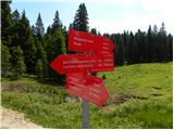 2
2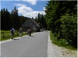 3
3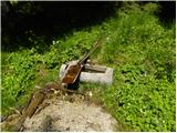 4
4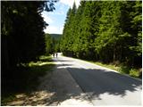 5
5 6
6 7
7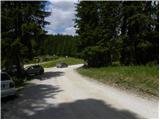 8
8 9
9 10
10 11
11 12
12 13
13 14
14 15
15 16
16 17
17 18
18 19
19 20
20 21
21 22
22 23
23 24
24 25
25 26
26 27
27 28
28 29
29 30
30 31
31 32
32 33
33 34
34 35
35 36
36 37
37 38
3839
 40
40 41
41 42
42 43
43 44
44 45
45 46
46 47
47 48
48 49
49 50
50 51
51 52
52 53
53 54
54 55
55 56
56 57
57 58
58 59
59 60
60 61
61 62
62 63
63 64
64 65
65 66
66 67
67 68
68 69
69 70
70 71
71 72
72 73
73 74
74 75
75 76
76 77
77 78
78 79
79 80
80
Discussion about the trip Koča na Pesku - Lake Ribniško jezero (via Lovrenška jezera)
To post a comment you must log in:
If you do not yet have a username, you must first
register.