Koča na planini Stador - Kobilja glava
Starting point: Koča na planini Stador (1050 m)
| Latitude/Longitude: | 46,19050°N 13,78250°E |
| |
Walking time: 1 h 15 min
Difficulty: easy marked way
Elevation gain: 425 m
Elevation difference along the route: 425 m
Map: Julijske Alpe - zahodni del 1:50.000
Recommended equipment (summer):
Recommended equipment (winter): ice axe, crampons
Views: 36.089
 | 2 people like this post |
Access to starting point:
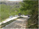
Between Most na Soči and Tolmin we notice signs for the village Poljubinj, which direct us onto a side road along which we soon arrive in the mentioned village. We continue driving on an ascending road which a little higher brings us to the village Ljubinj, where we continue left in the direction of the hut on the mountain pasture Razor and mountain pasture Stador. Further, we ascend on a narrow, steep and asphalted road which after some time brings us to the parking lot by the road near the hut on the mountain pasture Stador.
Route description:
From the parking lot, we first walk to the hut on the mountain pasture Stador, and then we head onto the footpath in the direction of Kobilja glava and Jalovnik.
From the hut, the path continues between fences, then turns slightly to the right, where it ascends somewhat more steeply, first across a grassy slope, and shortly after through a short stretch of forest. At the top of the mentioned ascent, the path brings us to a panoramic grassy ridge, from which a nice view opens towards Tolmin. The well-marked path continues to ascend along the wide and partly vegetated ridge of Šprinca (1251 m). Higher up, the path transitions from sparse forest to increasingly panoramic slopes, along which we climb to the aforementioned Šprinca, where a large cairn stands.
We continue the ascent along a pleasant path that shortly brings us to a solitary hut. Further on, we ascend a moderately steep path that, with fine views, leads us to a somewhat larger watering place for animals. We continue the ascent on a somewhat less visible but orientationally undemanding path that higher up brings us to the main ridge, where an unmarked path from the mountain pasture Lom joins from the left. Here we continue right and in less than 5 minutes of further walking step onto the summit of Kobilja glava.

Along the route: Šprinca (1251m)
Photos:
 1
1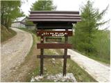 2
2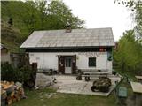 3
3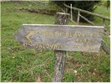 4
4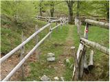 5
5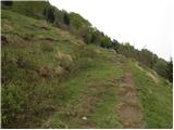 6
6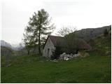 7
7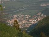 8
8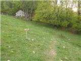 9
9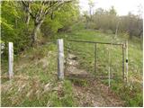 10
10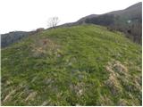 11
11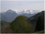 12
12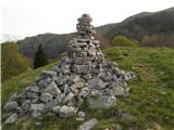 13
13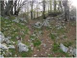 14
14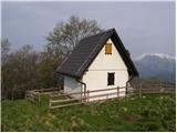 15
15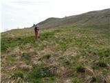 16
16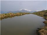 17
17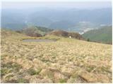 18
18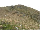 19
19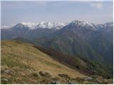 20
20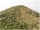 21
21 22
22
Discussion about the trip Koča na planini Stador - Kobilja glava
|
| sergejom8. 12. 2010 |
Can any T'minc tell me how far the access road to Planina Stador is. Given the thaw, I assume the road is dry. Can one reach Planine Lom, Kuk and Razor too?
Thanks in advance
Best regards Sergej
|
|
|
|
| bostjan8528. 12. 2012 |
I'm also interested in this road, is it fully asphalted?
|
|
|
|
| miri28. 12. 2012 |
Asphalt to planina Stador.
|
|
|
|
| lepenatka29. 04. 2013 |
Hello,
does anyone have any info on the road conditions to Planina Stador?
Thanks in advance for any info.
|
|
|
|
| miri29. 04. 2013 |
386 (0)31 425 270
Try there. Hut keeper at the planina. Best
|
|
|
|
| Tomažke30. 04. 2013 |
It is passable. Paragliders have been driving up there for some time. 
|
|
|
|
| Tolminc30. 04. 2013 |
The road is normally passable (was up there 18.04.2013), at several places they have slightly widened the road, so meeting is also easier
|
|
|
|
| valerija11225. 09. 2014 |
Hello! Please, those familiar with the path, explain how to find the unmarked path to planina Lom from the top of Kobilja glava. We would like to do a circular route and also visit Tolminski Triglav. Thank you very much.
|
|
|
|
| julika25. 09. 2014 |
When you reach the top of the ridge from planina Stador, the path branches to the right - Kobilja glava, to the left towards planina Lom. The path runs along the top of the ridge.
|
|
|
|
| valerija11226. 09. 2014 |
Julka and Suzana, thank you very much. We're going up today, hoping the sun will greet us.
|
|
|
|
| masker20. 08. 2016 |
Today I was at the top of Kobilja glava from Kobale near planina Stador. I drove there by car on the asphalt road, which is quite narrow in places. The path to the top of Kobilja glava is quite steep but relatively easy. Ideal for maintaining fitness. Definitely a nice hiking trip. At the top, a beautiful panoramic view of the surrounding hills, only towards the Bohinj hills misty clouds hid their peaks.
|
|
|
|
| Jani33321. 09. 2018 |
Hello,
I'm interested if there is any stamp for Kobilja glava? Maybe in some hut, association?
thanks for the answer
Best regards J
|
|
|
To post a comment you must log in:
If you do not yet have a username, you must first
register.