Koča pod slapom Rinka - Brana
Starting point: Koča pod slapom Rinka (1024 m)
| Latitude/Longitude: | 46,36960°N 14,59860°E |
| |
Walking time: 3 h 45 min
Difficulty: difficult marked way
Elevation gain: 1229 m
Elevation difference along the route: 1223 m
Map: Kamniške in Savinjske Alpe 1:50.000
Recommended equipment (summer): helmet
Recommended equipment (winter): helmet, ice axe, crampons
Views: 119.202
 | 4 people like this post |
Access to starting point:
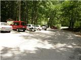
We drive to Luče (from Mozirje or via Kranjski rak) and onwards towards Logarska dolina. Soon after the village Solčava we come to a junction, where the road to Logarska dolina branches off to the left. We turn left towards Logarska dolina (toll payment) and drive along the road to the parking lot at the mountain hut Koča pod slapom Rinka, where we park.
Route description:
From the parking lot, we head onto a wide tourist path which starts gently ascending. After a good ten minutes of walking, we come out of the forest, where we arrive at a junction. We go left (right Orlovo gnezdo 3 minutes) in the direction of Dom na Okrešlju. The path ahead crosses a small bridge and on the other side starts to ascend more steeply. After a short ascent, the path brings us below the walls, from where a crossing to the top of the waterfall follows. This part is exposed to falling stones. The path then crosses Savinja again and further ascends along the river with the help of steps. Next we ascend on the right side (left bank) of Savinja. Soon we come to the source of Savinja, where we cross the water again. On the other side, the path goes into dense forest and after a short ascent brings us to the winter shelter on Okrešlju. We continue left and in a few steps we come to Dom na Okrešlju.
At the hut we head onto the path in the direction of Kamniško sedlo and Savinjsko sedlo. Soon we come to the edge of a panoramic meadow, where there is a junction. We continue left in the direction of Kamniško sedlo on the path which first moderately ascends through the forest and then across a belt of shrubs. The path then levels out completely and in a short crossing brings us to the scree, on which we ascend on a well-made path to the entrance into the less demanding wall. Further with the help of numerous fixed protections we ascend one level higher, where the steepness eases somewhat, but the path is still quite steep and exposed to falling stones. Higher the path brings us to a steep scree that is dangerous for slipping in snow, which we merely cross. A short ascent follows on a wide and somewhat exposed ledge, after which the path brings us to the extensive grassy slopes of Kamniško sedlo. Just a few steps further we come to a junction, where we continue right in the direction of Turska gora and Brana (left Kamniška koča na Kamniškem sedlu 10 minutes). The path, which further ascends the increasingly rocky slope, quickly brings us to scree that is dangerous for slipping in snow. We cross the scree in a gentle traverse ascent, then the path brings us to the next junction, where we continue left (right Turska gora). The path ahead ascends ever more on the shady slopes of Brana. The steep path secured at key points, which is not particularly demanding, soon brings us into a small gully, up which we ascend with some easy scrambling to a nice vantage point. Here we continue sharply right on the path which after a further 10 steps brings us to the summit slope of Brana. Here the steepness eases and the nice panoramic easy path brings us in a few minutes to the spacious summit.
Koča pod slapom Rinka - Dom na Okrešlju 1:15, Dom na Okrešlju - Brana 2:30.

Photos:
 1
1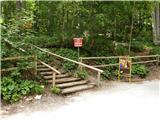 2
2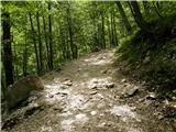 3
3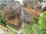 4
4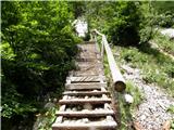 5
5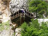 6
6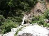 7
7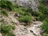 8
8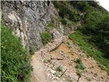 9
9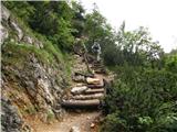 10
10 11
11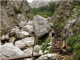 12
12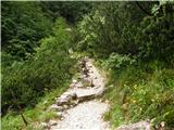 13
13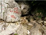 14
14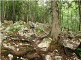 15
15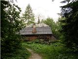 16
16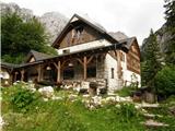 17
17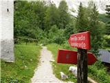 18
18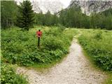 19
19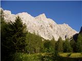 20
20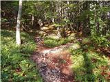 21
21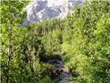 22
22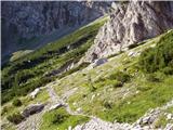 23
23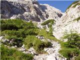 24
24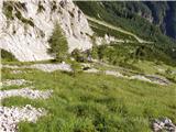 25
25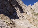 26
26 27
27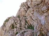 28
28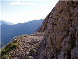 29
29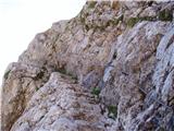 30
30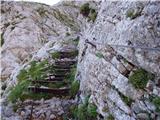 31
31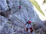 32
32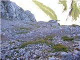 33
33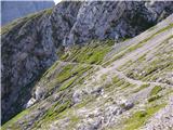 34
34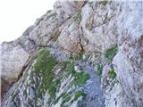 35
35 36
36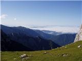 37
37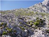 38
38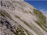 39
39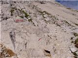 40
40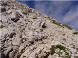 41
41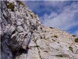 42
42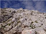 43
43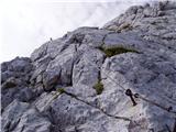 44
44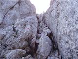 45
45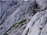 46
46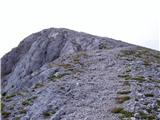 47
47 48
48
Discussion about the trip Koča pod slapom Rinka - Brana
Show older messages
|
| sergejom3. 07. 2009 |
What's the path like from Kamniško sedlo to Brana (snow patches on the north slope)?
|
|
|
|
| sergejom3. 07. 2009 |
Thanks Klin.
You're prompt. 
|
|
|
|
| garmont17. 06. 2010 |
Has anyone recently walked from Okrešlju to Brana? I want information on snow patches under the north face of Brana (climbing path from Okrešlju) and on snow on the scree slope which you cross when ascending to Brana. Thanks for answers. LP
|
|
|
|
| miha8911. 06. 2011 |
Hiked it today with friends, very nice path except occasionally still some winter influence visible (snow, some loose rocks on the path).
|
|
|
|
| Kanja8. 07. 2011 |
Which path to Brana is the easiest? This one is probably the most beautiful?
Triglav and for example Raduha via ferrata didn't cause me trouble.
|
|
|
|
| geppo8. 07. 2011 |
The access is even easier if you go from Kamniška Bistrica. Then to Brana it's the same path anyway and it's not connected to the starting point.
I suggest you take this description as starting point. So, from Okrešelj.
It's not any harder than Raduha on the "very demanding".
|
|
|
|
| alpin8. 07. 2011 |
On the path to Brana you just need to pay attention not to continue too low at the beginning of the path from Kamniško sedlo (lower path), which leads to Kotličeva and Turska gora. You continue the path on the northern side of Brana on the upper path. L.P.
|
|
|
|
| VanSims8. 07. 2011 |
How is the snow on the path? This weekend there will obviously be nice weather and I would climb to Brana from Okrešelj.
Does anyone know when they start collecting parking fees in Logarska?
Otherwise I have Kamniško bistrico by bike in one hour but this path seems more interesting, although my colleague says that because I'll see a couple more pitons it's not worth going from Logarska
|
|
|
|
| geppo8. 07. 2011 |
I think the snow shouldn't cause you trouble.
A minute or so past seven you can usually zip through the "customs". And you know: early hour....
LP
|
|
|
|
| VanSims10. 07. 2011 |
Thanks geppo and jozeb. I was on Brana yesterday, there's actually no snow anywhere anymore. Nice trip!
|
|
|
|
| fallen10014. 07. 2011 |
how, is this path recommended for a fairly beginner in high mountains, as one of the first "higher" paths in the Kamnik Alps
cheers fallen
|
|
|
|
| jure10014. 07. 2011 |
I was on Brana a month ago, it was my first ascent in quite nice time...
But it's fairly demanding. You have to make sure you have enough fitness also for the descent.
|
|
|
|
| fallen10014. 07. 2011 |
aha ok, fitness doesn't worry me I thought I need more technical knowledge (which I have some of)
|
|
|
|
| Paintball15. 07. 2011 |
Fallen100, Brana is just the right mountain for introducing to high mountains. Difficulty approximately like to Kamniško sedlo from Logarska (wall section).
|
|
|
|
| fallen10015. 07. 2011 |
aha then it's nothing much, since I've already gone to Kamniško from Logarska thanks a lot ^^
|
|
|
|
| VanSims15. 07. 2011 |
The difference between Kamniško from Logarska and further to Brana from Kamniško is that the first is much better secured than the second, which has only two fixed ropes and three pegs, yet it's called secured.
So my colleague wasn't right: I saw many more pegs and ropes when going from Logarska. I think if a path is declared secured, it should really be, or called unsecured, which practically it is further to Brana.
Difficulty further to Brana is a shade harder, mainly requires some free climbing, which isn't demanding except maybe that chimney.
Descent isn't much harder, but annoying due to scree. That chimney seemed even harder upwards. All this assuming you move facing the rock on climbing sections. Then you can even bypass some scree by climbing on firmer ground.
|
|
|
|
| panda16. 07. 2011 |
Ascent to Brana is the easiest in this area around Kamniško sedlo and Turska gora. There's no easier. Chimney? Nothing like that. In my opinion, the path to K. sedlo from Logarska (especially climbing part) is more demanding than from K. sedlo to Brana.
|
|
|
|
| fallen10024. 07. 2011 |
thanks for the information
|
|
|
|
| aonuk125. 07. 2011 |
I've read (Koča pod slapom Rinka) several times already. Now I'm wondering where this hut is? (Is it perhaps the eagle's nest, or the buffet at the parking lot?)
Safe steps...
|
|
|
|
| rklemens2. 08. 2011 |
This hut was near the snack bar at the parking lot, but it was destroyed by a snow avalanche years ago. l.p.
|
|
|
|
| Becar5. 08. 2012 |
On 5.8. I did this path. At the summit there were only four of us, which surprised me a lot given the time. This time at the entry to the wall below the saddle I hesitated a bit whether to enter it, namely stones were falling down continuously. Someone said that three chamois were frolicking up there . Possible. Given the seen indifference of some visitors, I would wonder if it wasn't some human chamois 
Best regards
|
|
|
|
| spyderskidoo26. 08. 2012 |
Can someone tell me how demanding this trail is compared to the trail to Triglav from Kredarica? Namely, 5 days ago I was on Triglav from Kredarica, on Wednesday I'm going to Kamniško sedlo and was looking a bit where else I could climb from there and Brana seems quite suitable. So is this trail much more demanding than the one from Okrešelj to Kamniško or how demanding is it compared to the Kredarica - Triglav trail?
|
|
|
|
| NEIC00827. 08. 2012 |
The trail to Brana is definitely less demanding than both mentioned trails.
|
|
|
|
| Gizmo27. 08. 2012 |
No need to worry about Brana if you've hiked the trail from Okrešelj to Kamniško sedlo. The trail is well maintained. Those two fixed cables pose no problem. Maybe a slightly awkward step in the chimney (one peg on the left wall wouldn't hurt). Then onwards it's an easy western slope leading to the mountain summit. On the way back down, due to the loose terrain, watch your secure steps, as the trail is slightly exposed in a few places.
|
|
|
|
| spyderskidoo27. 08. 2012 |
aha thanks for the detailed description...I'll attach some photos when I return
|
|
|
|
| vmaric221. 02. 2013 |
Politely asking frequent visitors of the path from Okrešelj to Brana for information on when is the most likely time to encounter ibex? In the holidays I would go there with my grandson!
Sincere thanks for the help.
Best regards Vilibald
|
|
|
|
| Becar21. 02. 2013 |
I encountered them on 4.8.2012, if it helps, they were above the entry part of the path into the wall towards the saddle. But I warn that the same animals were sending whole salvos of stones down the wall, so despite the coolness there was a bit of uncomfortable feeling with the whistling of stones. Some of us waited under the overhang of the wall until they calmed down.
|
|
|
|
| jprim21. 02. 2013 |
@vmaric2
Here's my advice, head to Bavški Gamsovec and it will be fine, around Kriške pode and Sovatna. Last year we went with that intention, to photograph them up close and admire them. Although we are quite often in KSA every year, we haven't encountered them there yet.
Best regards!
|
|
|
|
| geppo21. 02. 2013 |
Hello
It's like predicting the weather for half a year ahead. From my many years of experience, I have never encountered them on the path from Okrešelj to Brana. Chamois often though. I last faced a herd of about 15 ibex on the path Turska gora - Kotliči.
http://shrani.si/f/d/7u/1iLwRPyn/img0126.jpg
I was lucky that my son was with me then and he could walk among them and photograph them. A cold front (in my opinion) drove them there and they found shelter. We walked among them and they weren't afraid of us, but lay in the grass watching us fearfully. We tried not to disturb them too much and took a couple of excellent shots.
I also met them on the path Škarje - Korošica, then Korošica - Kamniško sedlo. You need really damn luck (kilometers), to encounter them in such a way as I did...http://shrani.si/f/35/Li/4JN9GLXt/img3179.jpg
best regards and lots of luck to you and your grandson
|
|
|
|
| Becar21. 02. 2013 |
I agree with the above comments, ibex are not seen very often in the mentioned area, I saw them only once in five or six visits to this path. So it's hard to advise in the sense: go then and you will meet them. If the desire for ibex is strong, it is really better to go to Kriške pode or the wider area, also around Stenar, Škrlatica etc. more often...
|
|
|
|
| Daaam21. 02. 2013 |
If distance is not a problem then under Montaž.. But it's interesting that I in the last few hikes exactly around Stenar /Kriške podi didn't catch ibex... only a few chamois in the distance. But last year I caught a group of ibex before the entry to the "climbing" (under Rinkami) path to Skuta..
|
|
|
|
| simonmanutd1. 07. 2014 |
What are the conditions on this path? Snow?
|
|
|
|
| otiv1. 07. 2014 |
Check the current conditions - Brana and everything will be clear.
|
|
|
|
| Sini26. 06. 2015 |
On yesterday's holiday it was nice to go above 2000. The path to Brana is nice, especially good that it's dry (for descent). A bit of mist, otherwise nice views.
|
|
|
|
| janagulin3. 07. 2015 |
On Tuesday during descent I lost my Garmin oregon device. If found, I would be extremely happy if you let me know at jana.gulin@gmail.com
Thanks!
|
|
|
|
| seinfeld27. 08. 2015 |
Today my son and I were on Brana from Logarska dolina. To me, the path to the saddle seems more exposed than further to Brana. There is quite a bit of climbing on rocks and searching for suitable holds, as there aren't many pegs and pitons. At the summit wonderful view and company of ptarmigans. We were early and met two ibex that posed for us, then disappeared. To the summit we needed exactly three hours of moderate walking. Helmet strongly recommended, as stones often fall; from wildlife, even more from people.
|
|
|
|
| istrumel10. 09. 2015 |
Yesterday on Brana from Logarska. We had a bit of everything, fog, clouds, wind, but little sun. Which weather site is the most accurate? I checked several, and there was more sun forecast.
|
|
|
|
| istrumel13. 09. 2015 |
Yes, it is. It's just good to have a cushion with you.
|
|
|
|
| Jurcekk14. 09. 2015 |
Thanks. We were there.. the cushion is then mandatory equipment
|
|
|
|
| Tina7824. 10. 2015 |
Hello mountain lovers... for now beautiful weather is forecast, so I'd like to take advantage of it to visit this beautiful mountain, so I'm interested in the conditions on the path starting from the hut below Rinka waterfall...thanks and best regards
|
|
|
|
| ljubitelj gora25. 10. 2015 |
Winter conditions below the summit, ice axe, crampons.
|
|
|
|
| jasminar15. 11. 2015 |
Hi, I'm wondering if there's any other way to get to Rinka waterfall, or is it only accessible by car?
|
|
|
|
| andrej7815. 11. 2015 |
by bike and on foot, or hitchhiking...that's it
|
|
|
|
| tynka tonka30. 06. 2016 |
Hi. Has anyone been up there these days... is there still any snow on the screes?
|
|
|
|
| nteam30. 06. 2016 |
Tonka,
I was there on 24.6. At that time there were only two snow patches on the scree path right before the start of the wall. It could be crossed without problems (and winter gear). In one week probably only a sample remains or even less. Higher under Brana there is no snow on the paths.
|
|
|
|
| redbull30. 06. 2016 |
 I've never seen a car parked at the Rinka waterfall I've never seen a car parked at the Rinka waterfall
|
|
|
|
| planika7712. 07. 2016 |
What is meant by this "chimney"? Is that therefore the most difficult or most exposed (most dangerous) part of the path to Brana? Can it be seen on one of the upper pictures? Or if someone has a picture, can they attach it here? Thanks in advance!
|
|
|
|
| jax13. 07. 2016 |
Picture 45. It's a bit fiddly, but you can get through.
|
|
|
|
| istrumel13. 07. 2016 |
The path is not difficult at all, you can go nicely through the chimney too, just need to watch where you step because of the crumbly rocks.
|
|
|
|
| Gizmo13. 07. 2016 |
@Planika77...that chimney is nothing special, when I first went up I climbed straight through the middle, mistake . You bypass it nicely on the left where you see the marker, and it'll be fine. Nothing is exposed. The whole path is quite crumbly, like most in this area. But it's fun all the way, follow the three points rule and it'll be ok. Smartly and with pleasure and safe steps I wish you.
|
|
|
|
| planika7714. 07. 2016 |
Ok, biggest thanks to everyone for the answers, I think I'll muster up the courage to go!
|
|
|
|
| zajko2. 08. 2016 |
At 81 I reached the top without problems, even through the chimney.
|
|
|
|
| Freya26. 08. 2016 |
We were up there yesterday. Weather was wonderful, the route is phenomenal. Personally, I think this route is better than the one from Kamniška Bistrica. It is true though that on Brana a few more pegs or ropes wouldn't hurt. Yesterday there were quite a few people and most didn't have proper footwear (Adidas sneakers)
|
|
|
|
| frajer8. 06. 2017 |
What are the conditions like??? Snowfield???
|
|
|
|
| cebelicaU22. 09. 2017 |
Hi, what are the conditions like, how much snow is there?
|
|
|
|
| gamsika29. 10. 2017 |
Hey,
has anyone been to Brana in the last week and knows what the conditions are like? Is there any snow, are crampons needed yet?
Regards
|
|
|
|
| MiAn29. 10. 2017 |
On the scree from the saddle towards Brana you need crampons and an ice axe.
|
|
|
|
| lepenatka11. 09. 2018 |
On Sunday quite a few visitors at Brana. But the nicest thing to me was this, which I want to share with you.
Friendly and kind creatures, accustomed to mountain paths.
Hope the owner doesn't mind.
Safe steps to all.
Regina
|
|
|
|
| Jurc8925. 07. 2020 |
Tomorrow I'm heading up. Can I go in La Sportiva Akyra lows or is it better to wear highs? Regards
|
|
|
|
| Enka25. 07. 2020 |
If you're used to hiking in the hills in lows, you can go, of course.
|
|
|
|
| redbull26. 07. 2020 |
Lows are acceptable if you're used to getting a pebble in the ankle etc. Some of us are used to it, so we also move in lows, otherwise absolutely at least mid-high boots.
|
|
|
|
| Jurc8926. 07. 2020 |
Thanks for the answers. I prefer high ones. Slo would also fit in those, but better this way. Lp
|
|
|
|
| Pohodnik_Miha25. 08. 2023 13:23:49 |
What are the conditions like after the floods? Has anyone been up there in the last 14 days? Can one reach the top?
|
|
|
|
| grmek19759. 08. 2025 08:13:41 |
I would ask what you think, with a 12-year-old child on this path, is a climbing harness and helmet recommended?
|
|
|
|
| jprim9. 08. 2025 20:11:22 |
Oh, the trail to the saddle itself is no problem. The start of the trail towards Brana isn't either. Just below the summit you need to be careful, as there are cables and some exposure, I'd take a helmet for safety and self-protection too if the child isn't used to such trails.
Best regards!
|
|
|
|
| XbooTheM26. 05. 2026 16:55:55 |
Today it was not passable, when we come under the wall (10 min before the junction wall with protections) it is not possible to continue. The snow is deep and sinks in, the path is covered, it is not possible to reach the protections from any side, in addition stones often crumble, very large pieces also fall.
|
|
|
To post a comment you must log in:
If you do not yet have a username, you must first
register.