Koča pod slapom Rinka - Skuta (via Turski žleb)
Starting point: Koča pod slapom Rinka (1024 m)
| Latitude/Longitude: | 46,36960°N 14,59860°E |
| |
Route name: via Turski žleb
Walking time: 5 h 15 min
Difficulty: very difficult marked way
Elevation gain: 1508 m
Elevation difference along the route: 1554 m
Map: Kamniške in Savinjske Alpe 1:50 000
Recommended equipment (summer): helmet, self belay set
Recommended equipment (winter): helmet, ice axe, crampons
Views: 76.821
 | 4 people like this post |
Access to starting point:
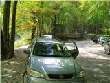
We drive to the place Luče (from Mozirje to here or via Kranjski rak) and continue towards Logarska dolina. Soon after the village Solčava we come to an intersection, where we turn left into Logarska dolina (toll payment in the summer season from 7:00 onwards) and we drive on the road to the parking lot at the mountain hut below the waterfall Rinka and we park there.
Route description:
From the parking lot, we head onto a wide tourist path which starts gently ascending. After a good ten minutes of walking, we get to the waterfall Rinka.
We continue in the direction of the mountain hut on Okrešelj. The path ahead crosses a small bridge and on the other side it starts ascending steeper. After a short ascent, the path brings us above the waterfall. This part is exposed to falling stones. After that, the path above the waterfall again crosses Savinja and then with the help of stairs ascends by the river upwards. We soon come to the source of Savinja. Then the path through the beech forest after a short ascent brings us to the winter shelter on Okrešelj. Approximately a hundred meters to the left, there is the mountain hut Dom na Okrešlju.
We continue across a meadow and right into the forest. The path ahead ascends by the scree slightly upwards. We soon come to the next junction, where we go left towards Turski žleb. At the junction there is also a memorial plaque. The path then starts steeply ascending and brings us to the entrance into Turski žleb. On the path through the gully it is recommended to use a helmet and self-belay set. The path then brings us to the entry into the climbing part of the path in the gully (or we can avoid it by continuing straight ahead on the scree). After a very demanding ascent on numerous pegs, the path becomes gradually less demanding and soon the last steel cables end. Next follows a relatively steep ascent on scree terrain to the top of the gully. In the upper part when we are ascending on scree we need to be very careful not to trigger stones.
On the top of Turski žleb, where there is also a junction we go right towards Skuta and Rinke. The path from the gully to the foot of Skuta is easy. At first, we ascend a little then descend a little and still cross the scree slope to the entrance into the wall of Skuta. In the wall on the path to the top we have fixed safety gear for help, mainly pitons. The path meanwhile brings us onto a very exposed small ridge above the ramp, where steel cables help us, and then the path goes again into the wall. Again pitons help us, which bring us to the summit part of Skuta. The steepness decreases a little and soon after that, we step onto the summit.

Photos:
 1
1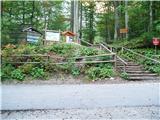 2
2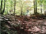 3
3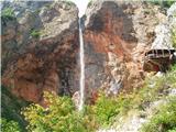 4
4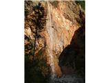 5
5 6
6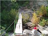 7
7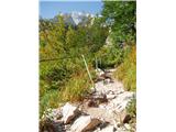 8
8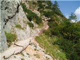 9
9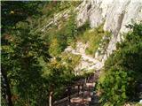 10
10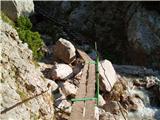 11
11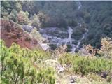 12
12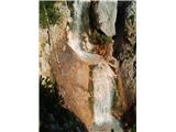 13
13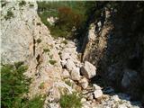 14
14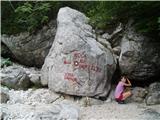 15
15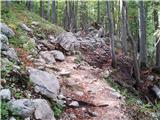 16
16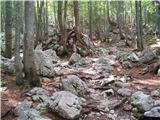 17
17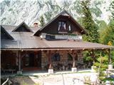 18
18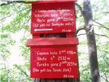 19
19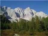 20
20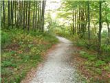 21
21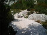 22
22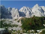 23
23 24
24 25
25 26
26 27
27 28
28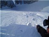 29
29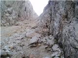 30
30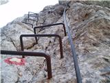 31
31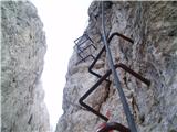 32
32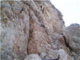 33
33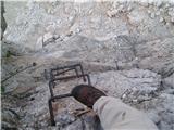 34
34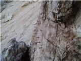 35
35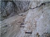 36
36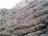 37
37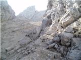 38
38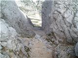 39
39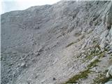 40
40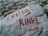 41
41 42
42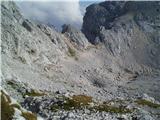 43
43 44
44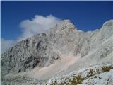 45
45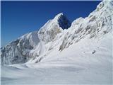 46
46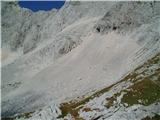 47
47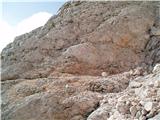 48
48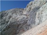 49
49 50
50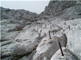 51
51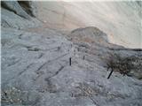 52
52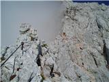 53
53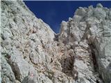 54
54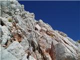 55
55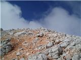 56
56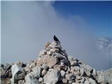 57
57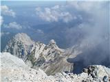 58
58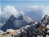 59
59
Discussion about the trip Koča pod slapom Rinka - Skuta (via Turski žleb)
|
| gasilec13. 10. 2009 |
Nice photos, but if I'm not mistaken, there is an error in the description of the last picture - on the left is Koroška Rinka (Križ), not Štajerska Rinka.
Best regards!
|
|
|
|
| Zasavčan22. 06. 2011 |
but who knows what tž and tg is?
|
|
|
|
| funnyboy22. 06. 2011 |
Turski žleb and Turska gora I assume
|
|
|
|
| fallen10015. 07. 2011 |
I'm generally interested, at Turski žleb, is it possible to bypass the climbing path and go over the scree, and which is safer (wall or scree)?
Best regards, thanks 
|
|
|
|
| geppo15. 07. 2011 |
A few years ago, a colleague who was afraid of the wall chose the scree for the ascent.
He didn't last long and soon opted for the wall.
I recommend the wall, and if you're scared, use a via ferrata set.
Once we descended via scree (out of the same youthful carelessness) to get down quicker.
We barely escaped larger rocks that were triggered by the gravel avalanche we caused.
|
|
|
|
| gti15. 07. 2011 |
If the first vertical doesn't suit you, you can enter the wall about 10 m later, then progress quickly without special features... Along the wall (via scree) you're very exposed to falling rocks, helmet mandatory, progress probably VERY slowly, not to mention the danger to those approaching below.
|
|
|
|
| fallen10015. 07. 2011 |
Thanks for the info  I'll definitely go via the wall, just wondered if I took a buddy without technical knowledge, how the whole situation would be for him I'll definitely go via the wall, just wondered if I took a buddy without technical knowledge, how the whole situation would be for him
|
|
|
|
| ljubitelj gora15. 07. 2011 |
Is a via ferrata set necessary on this path?
Thanks LP
|
|
|
|
| funnyboy15. 07. 2011 |
It's not necessary anywhere, but it's nice to have it. Of course, many don't have it and still manage fine. Decide based on your knowledge and experience. I'd take it LP
|
|
|
|
| plansar1231. 08. 2012 |
I heard that Turski žleb is supposedly closed, is that true? Does anyone know more about it? On Saturday I would go from Koča na Okrešlju over Turski žleb to Turska gora, then to Skuta and to Cojzova koča where I would overnight...
|
|
|
|
| lepenatka1. 08. 2012 |
Hello,
Turski žleb is not closed, as it wasn't on Saturday. And there was quite a bit of traffic and rockfall too.
In the upper part you just have to walk like a ballerina, so as not to endanger those below you.
Safe steps and much enjoyment.
|
|
|
|
| jprim1. 08. 2012 |
@ plansar123
Turski žleb, Turska gora, Skuta, Cojzova koča, Okrešelj 
|
|
|
|
| Jure S1. 08. 2012 |
There were plenty without protective helmets too, falling rocks bothered them the most 
|
|
|
|
| lepenatka2. 08. 2012 |
Also those with helmets. During my ascent we all had them and there were quite a few of us.
Despite proper gear you need to watch how you move on such terrain to not endanger others.
A helmet isn't omnipotent either.
|
|
|
|
| franjo6614. 09. 2012 |
IS THERE ANY SNOW ON SKUTA?
WHAT WILL CONDITIONS BE LIKE ON SUNDAY
|
|
|
|
| viharnik14. 09. 2012 |
There is snow in KSA in the mountain interior above 1800m up to 5-10cm and it still persists. Interestingly, there was almost none on the southern side of Krvavška, but above Pastirci below Kam.sedlo it is still all white. On Sunday there will be little of this snow left, mainly patches in shady spots and hollows on the south, but enough for slipping if walking carelessly on the more difficult rocky sections.
|
|
|
|
| Matjaz_651. 11. 2013 |
a few more of my photos ... otherwise with the ascent variant over Rinka
|
|
|
|
| smatjaz1. 11. 2013 |
Matjaž Super photos, but did you notice me waving from Ojstrica?
|
|
|
|
| simonmanutd3. 07. 2014 |
How is it with snow in the gully? Passable without winter gear?
|
|
|
|
| ljubitelj gora3. 07. 2014 |
No, for more check out this picture taken from Kamniško sedlo. http://shrani.si/f/0/iG/SFo5Rg4/img5567.jpg zig-zag is the path to the gully
|
|
|
|
| Sano3. 07. 2014 |
There is still quite a bit of snow in the gully (27.6.), in my opinion winter gear is mandatory.
|
|
|
|
| dare295. 07. 2014 |
Strikan's picture from the path to Mrzla gora 29.6.
|
|
|
|
| črna murka13. 08. 2014 |
There's still quite a bit of snow in the gully. Winter gear is not necessary, because there's none at the entry to the fixed cables. However, the cable is torn in one section. It's replaced with a rope, it's safe but the feeling isn't the best.
|
|
|
|
| franjo663. 09. 2014 |
What are the conditions like towards Skuta?
|
|
|
|
| redbull4. 09. 2014 |
ok, yesterday there was still some fresh snow, but by Friday it will be gone.
Tour report:
deyangrm.blogspot.com
lp
|
|
|
|
| Hribolazec819. 08. 2025 13:03:15 |
Turski žleb, torn piton and cable, so be careful
|
|
|
|
| jurijhojnik15. 08. 2025 20:52:32 |
Is it normally passable where the peg and cable are torn off or dangerous?
|
|
|
To post a comment you must log in:
If you do not yet have a username, you must first
register.