Koča pri Savici - Planina Lopučnica (via Dvojno jezero)
Starting point: Koča pri Savici (653 m)
| Latitude/Longitude: | 46,28960°N 13,80220°E |
| |
Route name: via Dvojno jezero
Walking time: 3 h 40 min
Difficulty: difficult marked way
Elevation gain: 905 m
Elevation difference along the route: 985 m
Map: Triglav 1:25.000
Recommended equipment (summer): helmet
Recommended equipment (winter): helmet, ice axe, crampons
Views: 30
 | 1 person like this post |
Access to starting point:
From the Ljubljana-Jesenice motorway, take the Lesce exit and follow the road towards Bled and further towards Bohinjska Bistrica. Continue driving towards Lake Bohinj (Ribčev laz), where you reach a junction, continuing straight along the left (southern) side of the lake towards Ukanc and Savica Waterfall. Follow this increasingly narrow road to the large parking lot at Savica Hut. The parking lot is paid.
Route description:
From the parking lot, head right towards Black Lake, Triglav Lakes Hut and Zlatorog Hotel (straight Savica Waterfall and Dom na Komni). The path initially leads along a gravel road that crosses the Savica River via a bridge. Just after the bridge, signs for Komarča direct us left (straight to Zlatorog Hotel) onto an initially quite wide and relatively gentle forest path. The path soon begins to ascend more steeply and takes us somewhat higher to a point where the path to the Savica spring and Velika Savica Cave branches left; we continue right along the increasingly steep path.
The well-maintained and relatively wide mountain path soon enters the very steep and slippery slopes of Komarča, where there is also a high risk of falling rocks. The path continues steeply ascending the mostly forested wall of Komarča, with safety gear, mainly cables, assisting on the more difficult sections.
Higher up, some views towards Bohinj open from the path, and it leads us to a short technically demanding spot where, with the aid of pegs and a cable, we cross a gully that is not particularly exposed. The path continues steeply ascending for a while longer and, with the help of some safety devices, brings us to the edge of Komarča, from where a fine view opens to our starting point. A short moderately steep ascent follows, after which the path begins to descend gently towards Black Lake, which we reach in less than five minutes of further walking.
Near the lake is a marked junction where the path to Planina Viševnik and Pršivec branches right; we continue slightly left along the marked path that skirts Black Lake on the right side. On the other side of the lake, the path from Dom na Komni joins from the left; we proceed along the relatively gentle path continuing along the edge of Lopučnica Valley. Higher up, the path begins a moderate ascent, bringing us along the edge of overhanging cliffs to a small spring that dries up in dry periods.
Continue along the marked path, which near Bela Skala turns sharply right and climbs steeply. Several minutes of steep ascent follow, then the path levels out and leads to a marked junction where the path from Planina Blato via Prode joins from the right. Continue left towards Triglav Lakes Hut along the relatively gentle path, arriving at Double Lake in ten minutes of further walking. The marked path bypasses the lake on the right and, before reaching the other side, leads to a junction where the path to Štapci and Mala Tičarica branches right.
Here continue straight and reach the Triglav Lakes Hut in a few minutes of further walking.
After resting and enjoying the views, continue towards Dom na Komni. The path ahead leads along the right (western) side of the lake, ascending transversely. A bit further, near the hunting hut (not visible from the path), the path curves semicircularly right and gradually begins descending. Roughly midway on the descent to Planina Lopučnica, on a small level area where the marked path we follow turns left, an unmarked trail branches right towards the Zgornje Komne plateau and Gladki and Debelem Laš (this path fades higher up in the karst terrain).
Upon reaching the junction lower down, we are already at Planina Lopučnica.
Starting point - Komarča edge 1:35, Komarča edge - Black Lake 0:05, Black Lake - junction above Lopučnica Valley 1:15, junction above Lopučnica Valley - Double Lake 0:10, Double Lake - Triglav Lakes Hut 0:05, Triglav Lakes Hut - Planina Lopučnica 0:30.

Photos:
 1
1 2
2 3
3 4
4 5
5 6
6 7
7 8
8 9
9 10
10 11
11 12
12 13
13 14
14 15
15 16
16 17
17 18
18 19
19 20
20 21
21 22
22 23
23 24
24 25
25 26
26 27
27 28
28 29
29 30
30 31
31 32
32 33
33 34
34 35
35 36
36 37
37 38
38 39
39 40
40 41
41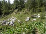 42
42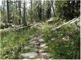 43
43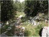 44
44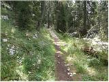 45
45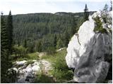 46
46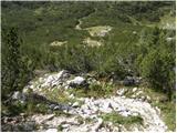 47
47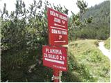 48
48
Discussion about the trip Koča pri Savici - Planina Lopučnica (via Dvojno jezero)
To post a comment you must log in:
If you do not yet have a username, you must first
register.