Koča pri Savici - Planina Viševnik
Starting point: Koča pri Savici (653 m)
| Latitude/Longitude: | 46,28960°N 13,80220°E |
| |
Walking time: 3 h 10 min
Difficulty: difficult marked way
Elevation gain: 972 m
Elevation difference along the route: 985 m
Map: Triglav 1:25.000
Recommended equipment (summer): helmet
Recommended equipment (winter): helmet, ice axe, crampons
Views: 11.971
 | 1 person like this post |
Access to starting point:
We exit from the Ljubljana - Jesenice highway onto the Lesce exit and follow the road towards Bled and further towards Bohinjska Bistrica. We continue driving towards Lake Bohinj (Ribčev Laz), and upon arrival at the intersection, we proceed straight on the left (southern) side of the lake in the direction of Ukanc and Savica Falls. We follow this increasingly narrow road to the large parking lot at the Savica Hut. The parking lot is paid.
Route description:
From the parking lot, we head right in the direction of Black Lake, the Hut at the Triglav Lakes, and Hotel Zlatorog (straight to Savica Waterfall and Hut on Komna). The path initially leads along a gravel road that crosses the Savica River over a bridge. Just a little after the bridge, the signs for Komarča direct us left (straight to Hotel Zlatorog) onto an initially still quite wide and relatively gentle forest path. The path soon begins to climb more steeply and brings us a bit higher to a spot where the path to the source of the Savica and the Velika Savica cave branches off to the left; we continue right along the increasingly steep path.
The well-maintained and relatively wide mountain path soon transitions to very steep and slippery-dangerous slopes of Komarča, where the risk of falling rocks is also high. The path continues steeply ascending along the mostly forested wall of Komarča, where safety features, primarily steel cables, assist us at the more difficult sections.
Higher up, a few views towards Bohinj open from the path, and the path brings us to a short technically demanding spot where, with the help of brackets and a steel cable, we cross a gully that is otherwise not so very exposed. The path continues to ascend steeply for a while longer and, with the aid of a few safety devices, brings us to the edge of Komarča, from where a beautiful view opens to our starting point. A short moderately steep ascent follows, after which the path begins to descend gently towards Black Lake, which we reach in less than five minutes of further walking.
The marked path turns right just a few steps before the lake and quickly brings us to a junction, where we continue right towards Planina Viševnik and Pršivec (straight to the Hut at the Triglav Lakes). The path ahead runs through dense forest for some time, then crosses a short panoramic slope and returns to the forest. Here, on the right side, a few dozen meters below the path, we will hear an interesting karst spring that descends through Komarča immediately after emerging (if we have time and desire, we can descend to the spring, but cautiously, as it ends with steep overhanging slopes).
The path, which runs through a little-visited area called Dol pod Stadorjem, then levels out for a shorter time and brings us to a small valley bottom where cold air often lingers. Further on, the path, which is often quite damp, enters the forest where it begins to ascend more steeply. The very quiet path emerges from the forest just a little before Planina Viševnik, from which only five minutes of easy walking separate us.
Starting point - edge of Komarča 1:35, edge of Komarča - Black Lake 0:05, Black Lake - Planina Viševnik 1:30.

The trip can be extended to the following destinations: Planina Blato,
Dom na Komni,
Planina Lopučnica,
Planina Dedno Polje,
Planina Ovčarija,
Koča pri Triglavskih jezerih,
Pršivec ( 45 min),
Mala Tičarica,
Slatna,
Velika Tičarica,
Kopica,
Čelo
Photos:
 1
1 2
2 3
3 4
4 5
5 6
6 7
7 8
8 9
9 10
10 11
11 12
12 13
13 14
14 15
15 16
16 17
17 18
18 19
19 20
20 21
21 22
22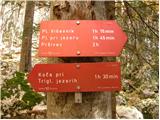 23
23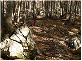 24
24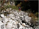 25
25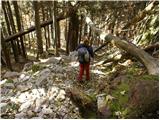 26
26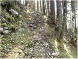 27
27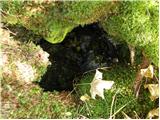 28
28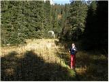 29
29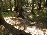 30
30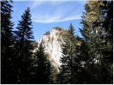 31
31 32
32 33
33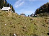 34
34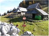 35
35
Discussion about the trip Koča pri Savici - Planina Viševnik
|
| MojcaH11. 07. 2009 |
Last week I went from Savica via Komarča to Črno jezero and continued on the path to planina Viševnik. The path went nicely to the viewpoint where markers were still visible. When I reached the scree and then past the spring there were no more markers, but the path was still well-trodden. It ran above the edge and turned right over a small stream and then lost itself among young spruces.
I'm interested if the path is marked all the way or not.
thanks for the answer
best
|
|
|
|
| Tadej11. 07. 2009 |
The path is fully marked and nicely passable.
|
|
|
|
| Daaam13. 09. 2010 |
Yesterday I went along this path. The path was really ambiguously marked before the spring/waterfall (about 20 min. from Črno jezero onwards) so my companion and I got lost too, and later three more hikers. Instead of turning further left onto the poorly visible path we went straight ahead on the well-visible hunting trail past the waterfall and further along the cliff edge towards Pršivec. With a bit of effort and adventure  we eventually found the right path. Since we later heard we weren't the first that day to "mess up" the junction, on the way back I took a couple of minutes to block that hunting trail a bit with stones we eventually found the right path. Since we later heard we weren't the first that day to "mess up" the junction, on the way back I took a couple of minutes to block that hunting trail a bit with stones  It's still possible to pass if someone wants to and knows the path, but for those intending to stick to the marked path I hope the obstacle helps them turn further right. It's still possible to pass if someone wants to and knows the path, but for those intending to stick to the marked path I hope the obstacle helps them turn further right.
Upon return though I realized the unmarked one is more to my liking (nicer and better views) so next time I'll definitely hop over the stones 
|
|
|
|
| Daaam13. 09. 2010 |
It's still possible to pass if someone wants and knows the path, but for those who intend to stick to the marked path I hope the obstacle helps them turn more to the right.
Sorry - more to the left is correct
|
|
|
|
| pojoča travica13. 07. 2015 |
Yesterday I took the marked path. The path is nicely marked, extremely peaceful, pleasant.
|
|
|
To post a comment you must log in:
If you do not yet have a username, you must first
register.